There is clear evidence of the ACT’s commitment to biodiversity protection.
A significant proportion of the ACT environment is protected; 55.22% of the Territory’s total 235 813 ha is contained in areas permanently designated as either nature reserve or national park. This is more than 10% higher than any other Australian jurisdiction and significantly higher than the national average of 17.88%.117
The ACT also has a comprehensive legislative and policy framework to conserve, maintain and improve biodiversity within these protected areas.
However, outside of protected areas, although there has been progress in conservation of natural resources (land, soil and water), progress in conservation of biodiversity, including both habitats and species, remains a challenge. This is particularly the case on rural leases (see Section 5.4). In addition, pressures leading to habitat loss and modification, for both terrestrial and aquatic ecosystems, continue to present a serious threat to the ACT’s biodiversity, with a high number of threatened and endangered species and ecological communities.
The ACT Government manages the pressures affecting biodiversity in the ACT in a variety of ways, which are examined in detail in Chapter 10. Particular features of biodiversity management and responses from the reporting period are included in this section.
7.4.1 Legal and policy framework
ACT
In the ACT, there are several laws that relate to biodiversity:
- Planning and Development Act 2007. The object of the Planning and Development Act is to provide a planning and land system that contributes to the orderly and sustainable development of the ACT. Under this Act, sustainable development means the effective integration of social, economic and environmental considerations in decision-making. In relation to biodiversity, the Planning and Development Act prescribes
- how environmental compensation may be made to offset the impact of developments that have a significant adverse environmental impact on protected matters
- how and under what circumstances environmental assessments must be carried out.
- Nature Conservation Act 2014. The main object of the Nature Conservation Act is to protect, conserve and improve the biodiversity of the ACT. The Act states that this is to be achieved by
- promoting and supporting the management, maintenance and enhancement of biodiversity of local, regional and national significance
- promoting the involvement of, and cooperation between, Aboriginal and Torres Strait Islander people, landholders, other community members and governments in conserving, protecting, enhancing, restoring and improving biodiversity
- encouraging public appreciation, understanding and enjoyment of biodiversity
- recognising and promoting Aboriginal and Torres Strait Islander peoples’ role in, and knowledge of, the conservation and ecologically sustainable use of biodiversity.
- Pest Plants and Animals Act 2005. This aims to protect the ACT’s land and aquatic resources from impacts caused by pest animals and plants.
- Heritage Act 2004. The Heritage Act aims to protect significant heritage and prescribes that natural heritage is significant if its biodiversity, geology, landform or other naturally occurring element(s) have scientific value.
- Emergencies Act 2004. The Emergencies Act directs all levels of bushfire planning in the ACT.
In the ACT, four strategies relate to biodiversity:
- ACT Nature Conservation Strategy 2013–2376 (prescribed by the Nature Conservation Act). This strategy provides direction on how to better integrate and extend conservation efforts beyond reserves to include natural areas across a range of land uses and tenures, and cross-border, to ensure that ecosystems remain healthy and well managed.
- ACT Pest Animal Management Strategy 2012–2022.118 This strategy provides the key principles, objectives and strategic actions for reducing the damage caused by pest animals.
- ACT Weeds Strategy 2009–2019.119 This strategy provides authoritative guidance to all parties involved in addressing weeds, with clearly stated objectives and identified priorities.
- Strategic Bushfire Management Plan 2014–19 (prescribed by the Emergencies Act). The SBMP provides the strategies by which critical ecological communities in the ACT can be managed to conserve their ecological values.
- ACT Environmental Offsets Policy 2015. This policy is a requirement under the Planning and Development Act 2007 and is implemented through a range of provisions under the Act, such as
- consideration of matters of NES through environmental assessment processes for referral to the ACT Conservator of Flora and Fauna and the Australian Government Minister for the Environment
- administration of the EPBC Act
- conditions of approval for protected matters as part of development approvals
- development of guidelines to assist in the development and consideration of environmental offsets
- calculation of offsets and maintenance of the offsets register
- development of offsets management plans.
In addition, the Nature Conservation Act establishes the position of the Conservator of Flora and Fauna, who must prepare and implement a Biodiversity Research and Monitoring Program every two years, and prepare a report at the end of the program.
Each year, an assessment is made of the natural assets described in the TAMS Bushfire Operational Plan. This assessment informs the development of five-yearly regional fire plans by ensuring that fuel management activities, including prescribed burns, slashing and grazing, are consistent with biodiversity conservation objectives, and that prescribed appropriate mitigation measures minimise potentially unfavourable environmental outcomes.
Australian Government
The Australian Government has biodiversity legislation that is applicable to the ACT.
The EPBC Act protects matters of NES. These matters include Commonwealth-listed threatened species, and ecological communities that inhabit or could potentially inhabit the ACT, and migratory bird species that fly through the ACT.
In the EPBC ACT, protection is given effect through two mechanisms:
- Development actions that may affect matters of NES must be assessed by the Australian Government Minister for the Environment.
- Strategic assessments are conducted that consider landscape-scale effects of development; unlike project-by-project assessments, which look at individual actions (such as construction and operation of a pipeline or wind farm), strategic assessments can consider a much broader set of actions (eg large urban growth areas such as Molonglo or Gunghalin).
The EPBC Act also promotes a partnership approach to environmental protection and biodiversity conservation through bilateral agreements with the ACT. On 16 June 2014, an agreement between the Australian Government and the ACT was executed that related to environmental assessment. According to the statement of reasons that were issued as part of this agreement, the Australian Government Minister for the Environment declared that the agreement:
- minimises duplication of environmental assessment processes
- provides more efficient and effective environmental assessment processes
- strengthens intergovernmental cooperation
- promotes a partnership approach to environmental protection and biodiversity conservation.
7.4.2 Management of pressures
A number of projects specifically designed to protect ACT fauna, flora and ecological communities have been conducted during the reporting period.
The ACT Government has partnered with Greening Australia to improve the condition, extent and connectivity of more than 1500 ha of lowland woodland areas across the ACT and adjacent to NSW. The six-year $2.155 million Building Restored Resilient Landscapes in the ACT and Greater Goorooyarroo project, funded through the Australian Government Biodiversity Fund, commenced in 2011. To date, the program has improved the condition, extent and connectivity of more than 1500 ha of lowland woodland areas. In 2013–14, on-ground works were focused on the Majura Valley, Kowen Plateau and Greater Goorooyarroo region adjacent to the ACT–NSW border. Activities included revegetation, weed and feral animal control, training and community engagement.
In the Tharwa Fish Habitat Project, two trial artificial log jams were constructed to enable channel deepening, improve habitat and improve ability of fish to pass through a river section. Monitoring of two log jams constructed in 2013 to improve fish habitat showed that water depth between the log jams had increased substantially from 40 cm before construction to 2.7 m after construction. Fish sampling found the log jams to be a hotspot for juvenile cod, with large numbers of juvenile Murray Cod and a juvenile Trout Cod (an endangered species) caught. Fish habitat has also been improved in five river reaches through the installation of 50 artificial fish habitats, dubbed ‘cod caves’. These were 500-kg cement balls with holes and caves that provide small places for fish to hide, live and breed. In 2013, cod caves were trialled in the Molonglo River to improve fish habitat. Fish are now inhabiting the caves.
Monitoring of a new population, and only the second extant population, of the critically endangered Ginninderra Peppercress commenced, and seed was banked with the ANBG. In addition, a large population of this endangered plant was translocated into Crace Nature Reserve, with extensive public participation and involvement of the Australian Minister for the Environment.
Monitoring of the Brindabella Midge Orchid continued. Seed was collected from the population in Namadgi National Park in collaboration with the ANBG, and research was conducted to propagate the species. Survey and monitoring were also undertaken for ACT rare or declared flora, including the Tarengo Leek Orchid, Canberra Spider Orchid and Small Purple Pea.
Vegetation mapping of more than 146 000 ha has been completed at Kowen, Majura and Jerrabomberra, and is in progress in other areas including Namadgi National Park.
Plantings of Drooping Sheoak (Allocasuarina verticillata) were completed to improve and increase habitat for Glossy Black Cockatoos, in partnership with Greening Australia and the Isaacs Ridge–Mount Mugga Mugga ParkCare Group.
Three new action plans were prepared with input from the ACT Scientific Committee and released in November 2013: Glossy Black Cockatoo, Little Eagle and Murrumbidgee Bossiaea. A revised action plan for the (possibly extinct) Smoky Mouse was also completed.
The initial two-year survey into the effects of Eastern Grey Kangaroo grazing on vegetation and reptiles within the ACT was completed. The Eastern Grey Kangaroo movement study, using GPS collars and digital mapping, continued at key sites around Canberra. Several community ParkCare groups conducted their own grazing studies, and hundreds of volunteers participated in kangaroo counts.
Development of reserve profiles continued for approximately 40 reserves under the Canberra Nature Park Plan of Management, in close coordination with the preparation of reserve operational plans by TAMS.
Preparation of an ACT Sphagnum Bogs and Fens Draft Management Plan commenced. The plan will provide a management framework for management actions and the monitoring of bogs, including adaptive management for climate change, in the ACT alpine sphagnum bogs and associated fens ecological community. The plan will include the Ginini Flats Ramsar Wetlands.
The ACT Nature Conservation Strategy 2013–23 was implemented during this reporting period. There have already been some progress and achievements:
- development of baseline information on landscape function; planning and restoration activities for enhancing connectivity; development of a weed alert and surveillance project; and protection of species and ecological communities through planning, monitoring and restoration activities
- soil landscape mapping at 1:100 000 scale, due to be completed by the end of 2015
- work on a hydrogeological landscape framework
- vegetation mapping of the Kowen Plateau and Murrumbidgee Valley (completed), and Namadgi National Park at 1:25 000 scale (due to be completed in 2015–16)
- incorporation of habitat connectivity mapping for wildlife into a connectivity GIS layer on ACTMAPi
- the launch of the Atlas of Living Australia ACT and Southern Tablelands Weed Spotter website, and a weed identification and mapping application on 12 June 2014
- planning for a biennial forum on nature reserves
- a range of research, monitoring and on-ground projects for protection of species and ecological communities
- biodiversity and climate change funding projects, and the Regional Delivery program, which continued to contribute to on-ground implementation of the ACT Nature Conservation Strategy.
Plant pests
Under the Pest Plants and Animals Act, the Minister may prepare a pest plant management plan for a pest plant that outlines the requirements for suppression or destruction of the pest plant (if it is achievable) or containment of the pest plant (if suppression or destruction is impractical).
In July 2014, two pest plant management plans were issued, for Chinese Fairy Grass and Fireweed.120,121
Chinese Fairy Grass
Chinese Fairy Grass is a hardy, rhizomatous, clumping perennial grass that is currently only known from one planting in the Australian National University near Fellows Oval. Other than in the ACT, no state or territory has yet formally listed this species.
A weed risk assessment was undertaken on the species in 2014, and reported that it was feasible to control at this stage and that eradication is the desirable outcome. Given the environments in which the species has naturalised in Australia and overseas, it is highly probable that it would find many suitable areas for establishment in the ACT. Chinese Fairy Grass primarily invades disturbed sites, but can be invasive in natural situations. For the ACT, it has been assessed as being a moderate threat to native species and ecological communities.
Fireweed
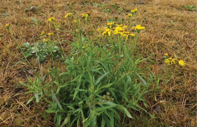
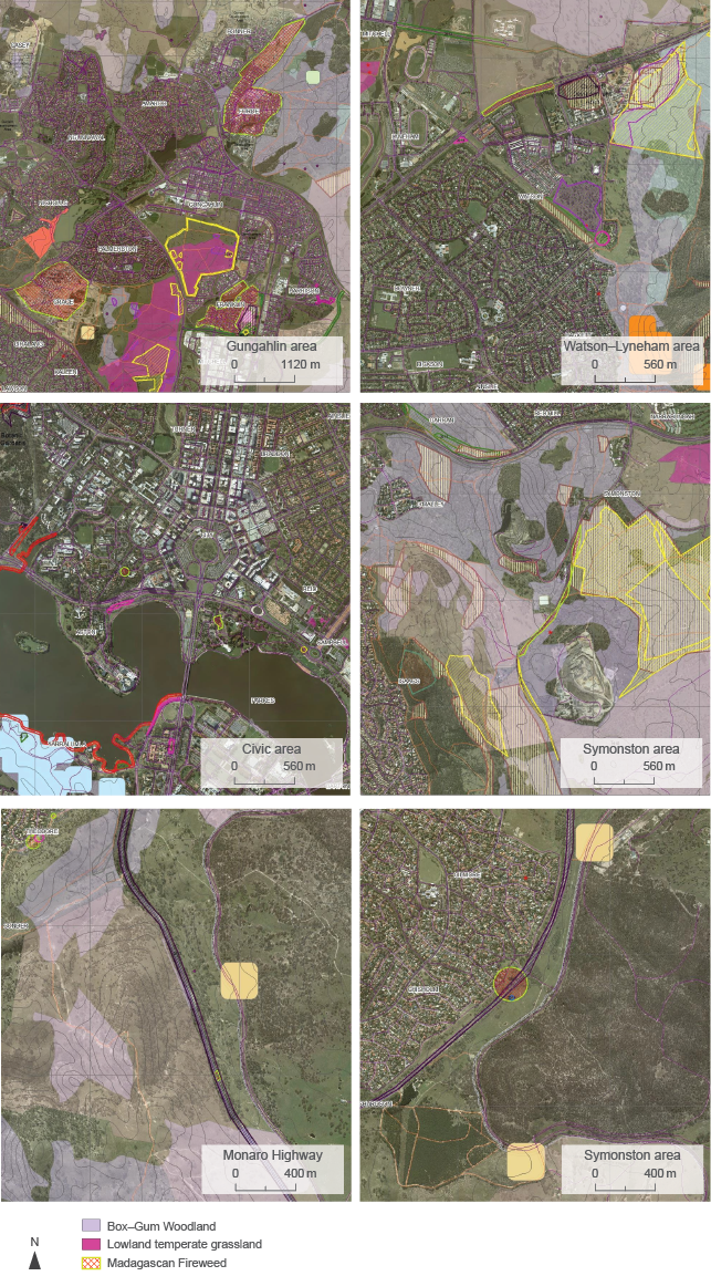
Fireweed has recently arrived in the ACT. There are large patchy and scattered infestations (10–20% cover) on nature strips in the new suburbs of Crace, Franklin and Forde. These infestations are of considerable concern because they are located close to Mulligans Flat Nature Reserve, Mulangarri Grasslands Nature Reserve, Gungahlin Hill Nature Reserve and the Mitchell grasslands. When the species was discovered in 2013–14, the ACT Biosecurity Plan was activated and a pest plant eradication program was put in place. This involved herbicide applications, hand-pulling and continued monitoring (S Hughes, Senior Manager, Biosecurity, Rural Services and Partnerships, pers comm, 30 September 2015). There are two other isolated infestations in suburban ACT: one site at Commonwealth Park and one plant confirmed in Mount Mugga–Mugga Nature Reserve (see Figure 7.46).

Fireweed in flowerPhoto: ACT Government

Figure 7.46 Maps showing location of Fireweed infestations in the ACT
Although the preferred habitats of Fireweed are disturbed sites (roadsides, railway easements and ‘waste’ areas, and grazed pasturelands), it has also been recorded in open woodlands, native grasslands, suburban bushland and parks. Many current Fireweed infestations are close to ACT nature reserves, including endangered grassland and open woodland reserves that have suitable soils, adequate levels of precipitation and other climatic factors, and open or ‘intertussock’ spaces. There is therefore a high probability that these important reserves will be conducive to Fireweed establishment.
Declared pest plants
In April 2015, the Minister issued the Pest Plants and Animals (Pest Plants) Declaration 2015, which identifies the pest plants that must be suppressed and contained.122
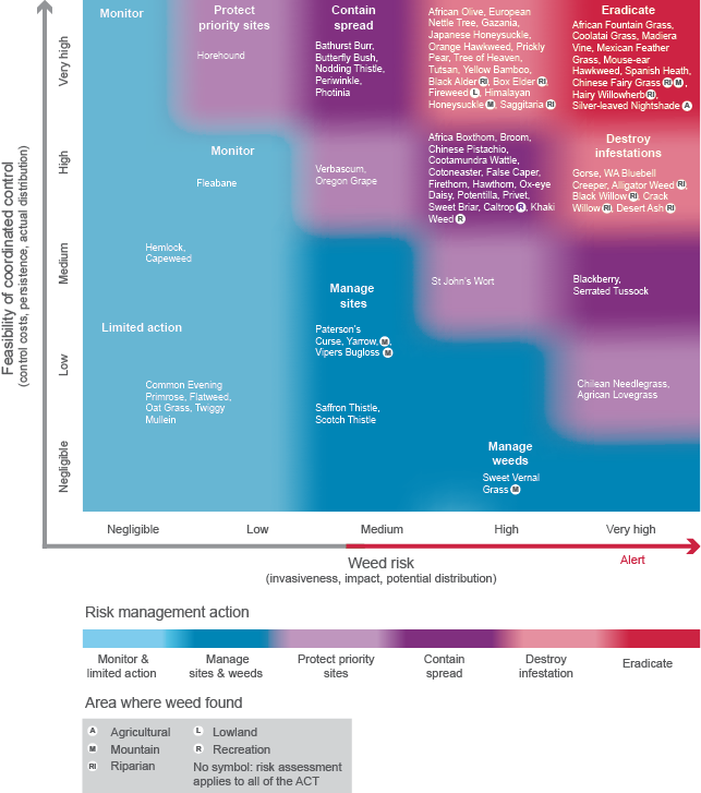
In 2014–15, a weed risk management action framework was adopted by the PCS, which was based on a system developed by the NSW Department of Primary Industries into which weed data from the ACT were applied (Figure 7.47).98 This framework is used to prioritise where investment in weed control is directed.

Figure 7.47 Feasibility of weed control in the ACT
Weed control
In 2013–14, more than 16 000 ha of the ACT received some form of control action by the PCS (see ‘Pressures’, ‘Pest plants’). As a result, from 2012 to 2015, there has been a large decline in the patchy cover class (10–50% density) and less decline in the scattered cover class (1–10% density); and a corresponding increase in the lightly scattered or isolated (<1%) cover class (Table 7.25). The increase in the dense cover class (>50% density) reflects primary control work tackling African Lovegrass and St John’s Wort infestations.
Table 7.25 Percentage of invasive weed control in each density class, by year
| Year | Density | |||
|---|---|---|---|---|
| <1% | 1–10% | 10–50% | >50% | |
|
2012–13 |
0 |
37 |
53 |
10 |
|
2013–14 |
25 |
25 |
25 |
25 |
|
2014–15 |
25 |
25 |
25 |
25 |