


ACT State of the Environment Report 2011
Accurate, timely & accessible information for the community regarding the condition of the environment, underlying pressures, and sustainability trends.
THEME: People
Indicator cluster: Natural hazards
Download: Indicator cluster: Natural hazards.pdf
The indicators for this cluster are:
- Flooding (C) - includes flood risk by area and type;
- Fire and settlement (C) - includes fire risk relating to community;
- Fire impacts (I) - includes fire impacts on the community;
- Flood impacts (I) - includes the number and type of floods, and flood impacts on community;
- Wind storms (I) - includes the number and type of wind storms and impacts on community;
- Fire management (R) - includes fire management from a human settlement perspective; and
- Flood management (R) - includes effectiveness of flood management responses including structural and non-structural actions.
Condition indicators (C) present data that tell us the state of the environment at any particular time.
Pressure indicators (P) present data about the main human activities that could potentially adversely affect the condition of the environment.
Impact indicators (I) present data on the effect that environmental changes have on environmental or human health.
Response indicators (R) present data about the main things we are doing to alleviate pressures, or to improve the condition of the environment.
Summary [top  ]
]
The ACT features rugged timbered mountains, hill country, grasslands and a network of river systems, and just over half the ACT comprises conservation areas. This, and the close proximity of bushland reserves to urban areas, increases the level of risk of property damage resulting from natural hazards such as floods, storms and fire. New greenfield and periurban developments extend the area of the ACT that is vulnerable to natural hazards such as fires. As the population of the ACT grows, and urban development extends, so the risks associated with natural hazards may increase.
Urban areas near to bushland reserves, hilly terrain or grassland are at greater risk from bushfire or grassfire than areas further away. Urban development, whether greenfield or urban infill, is associated with impervious surfaces from which water must run off, unable to soak into the soil. In heavy rainstorms impervious areas increase the chance of flash runoff and localised flooding. Climate change is predicted to lead to more frequent and more intense natural hazards associated with extreme weather conditions and events. During the reporting period there were 4 major storm events, including heavy hail in east Tuggeranong on 31 December 2007 and a tornado in Gungahlin on 22 January 2009. As well as storm, fire and flood, identified risks related to climate change include extreme heat and related public-health impacts, and vulnerability of water resources.
The ACT Government has made considerable progress since the last reporting period in improving planning and systems for managing natural resources and mitigating potential hazards. A common theme has emerged, of shared responsibility between citizens and agencies to prevent and respond to natural hazard events.
Introduction [top ]
Natural hazards are naturally-occurring sources of potential harm, or an existing condition that may cause harm to people or damage to property or the environment. Population growth and urban development in some locations can increase exposure to natural hazards such as flood and fire, with potentially significant impacts on people, buildings and infrastructure (Geoscience Australia 2007). This indicator cluster examines the risk and management of natural hazards, particularly flood, fire and storms, in the ACT over the reporting period.
Condition indicators [top ]
During the current reporting period, 2007-2011, unlike the previous reporting period (2004-2007), the climatic conditions ranged from drought to higher than average rainfall in eastern Australia (BoM 2011) as a result of the La Niña weather. Rainfall figures for the ACT for 2008-2010 are shown in Figure 1.
Figure 1. Rainfall at Canberra airport 2008-2010
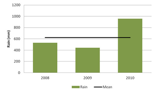
Source: BoM 2011
Flooding
Flooding can be broadly categorised into two groups: river flooding and urban flooding. Factors that can influence the severity of flooding, apart from intensity of rainfall, include land use, urban density, elevation, site slope, antecedent moisture conditions, soil type and the amount of water that can be stored in the catchment.
River flooding
River flooding occurs when a river's flow exceeds the capacity of its channel. In the ACT flooding can occur when there is heavy rainfall in the catchments of the rivers and streams that pass through the ACT. Two of these, the Murrumbidgee River and the Molonglo River, have large upstream catchments within NSW. Heavy rainfall in the Queanbeyan River catchment, a tributary of the Molonglo River, resulted in a significant flood event in December 2010, with impacts that affected water quality in Lake Burley Griffin.
Hydrological studies to support Canberra's development have produced a large body of knowledge on local flooding. As a result, local rivers and many of the creeks around Canberra have flows modified by dams, flood retention basins or pollution traps.
Urban flooding
Stormwater runoff in urban areas from heavy rainfall events can create localised flash flooding. Roads, carparks and roofs are impervious and shed water during rain events. If the rain is heavy and the impervious areas are large compared to interspersed vegetated areas such as gardens, parks, reserves and playing fields, the volume of runoff can exceed the capacity of drains and stormwater channels and result in temporary local flooding.
In low-lying or relatively flat urban areas, heavy rain can cause concrete-lined stormwater drains to overflow. If heavy rain exceeds the capacity of in-ground pipes under walkways and pavements in steep urban areas there can be overland flow, and water may accumulate as a localised flood (ACTPLA 2010).
Urban areas of the ACT generally include more vegetated areas than other Australian cities. In vegetated areas, rain is often absorbed into the soil relatively quickly, mitigating flood risk.
Storms
Data on storm numbers are limited, but a large increase in requests to emergency services for assistance with storm and flood damage (Figure 2) aligns with the increase in rainfall in 2010 (Figure 1).
Figure 2. Requests for assistance because of storm and flood damage
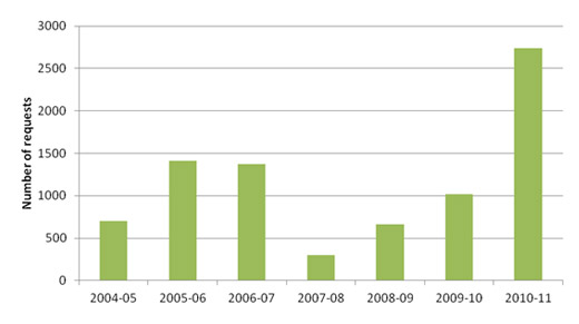
Source: ESA 2011
Fire and settlement
The topography of the ACT poses challenges for fire management, especially along the western boundary of the ACT where there is a heightened risk of bushfire from the north and west. Approximately 60% of the Territory comprises hills or mountains (ACT Government 2009a).
The ACT also has extensive forest areas and grasslands. Conservation areas occupy approximately 53% of the land area and, as noted previously, within Canberra itself there is a high proportion of green space within the urban development area.
This combination of landscape and vegetation, compounded with the warm dry climate of inland Australia, exposes Canberra to a high risk of bushfire. Individual fire events combined with drought and heightened fuel loads can lead to bushfires of considerable size and ferocity, resulting in property damage and even loss of life (ACT Government 2009a).
Nine large severe fires have occurred in the ACT since the beginning of the 20th century (ACTPLA 2010). In the worst of these (January 2003), hundreds of houses were damaged or destroyed, heritage and other buildings and infrastructure were also burnt out or otherwise affected, and four lives were lost. There is now a high level of awareness of the risks posed by bushfire in the ACT (ACTPLA 2010).
These events are currently the focus of a major international collaborative research project (Fromm et al. 2010). This research, as well as other assessments, found that the 2003 fire was of a type not observed in Australia before 2001 (Dold et al. 2005, Fromm et al. 2006). It behaved in ways that were fundamentally different to previous fires, and a critical component was the ACT's rugged landscapes. Further work, via a climate modelling project that is modelling relative humidity and vertical air flow effects on wildfire, is examining increases in bushfire risk in relation to climate. The 2003 ACT fire has helped build knowledge of fire behaviour and risk (McRae and Sharples 2011), and strategies for mitigating this type of fire are still being developed through further research.
Large areas of fire-affected vegetation are prone to what is termed a re-burn fire (Pyne and Omi 1986) and this will be a significant source of risk in the next few summers in the ACT. There have been no re-burn fires in the ACT since 2003, although one occurred across the border in NSW on 25 Feb 2006.
Over the reporting period, fires across the ACT peaked in 2006 with 486 fires, which was significantly more than in any other year during the period (Figure 3). There were fewer fire events in 2010, possibly because the spring and summer had above-average rainfall (Figure 1). Most fires in the ACT occur close to urban areas, cover less than 5 hectares and are ignited by people, either intentionally or accidentally (ACT Government 2009a). Fires were largely small vegetation fires (less than 1 hectare in area), burning grassland or a mixture of scrub, bush and grassland.
Figure 3. Total bushfires and grassfires by type January 2004 - June 2011
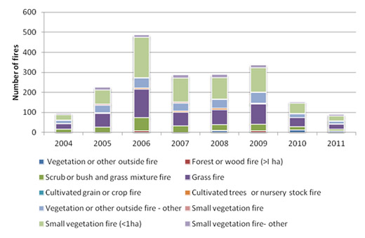
Source: ESA
Storms
Wind storm events are commonplace across the ACT, particularly between September and February. They can arise from cold fronts, thunderstorms, synoptic winds or foehn winds (dry strong winds blowing downslope).
In 2008, 26 days of strong winds were recorded, including one gale in September with wind speeds up to 98 km/hr. These were the strongest winds the ACT had experienced for nearly 3 years: trees fell on houses and several people were injured. In 2009, 25 days of strong winds were recorded and the strongest wind gust (at Canberra airport) was 106 km/hr in January; it was the strongest gust recorded since 1996. In 2010, there were 22 days of strong winds, and the speed of the highest wind gust recorded at Canberra airport was 85 km/hr in September. A gust at 109 km/hr was recorded at Mt Ginini, in the Brindabella Range, in the same month (BoM 2011).
A number of severe thunderstorms have been associated with storm damage during the reporting period. The 4 major storm events (2 in 2007 and 2 in 2009) included a heavy hail-fall event in east Tuggeranong on 31 December 2007 and a tornado in Gungahlin on 22 January 2009.
The ACT also experiences duststorms. A duststorm initially masked the ignitions of fires on 8 January 2003. During the reporting period, duststorms generated in various regions of inland Australia passed over the ACT, mainly during September and October 2009, reflecting the drought conditions at the time. There were no duststorms during the high rainfall period associated with the 2010 La Niña.
In 2009, 2 duststorms were recorded in the ACT, during which visibility was reduced to 3-4 km. These were a result of the very dry conditions across inland Australia, coupled with a cold front moving across from the west, causing dust to be raised by the strong westerly-northwesterly winds preceding the front.
For more information on long-term changes in wind speed see the Driving Forces paper. For more information on the predicted increase in temperatures, wind and events resulting from climate change, see the Climate vulnerability indicator cluster paper in the Climate theme.
Pressure indicators [top ]
There are no pressure indicators for natural hazards.
Impact indicators [top ]
Flood impacts
Historically, flooding events in Canberra have not been frequent but have caused injury, loss of life and property, and infrastructure damage. For instance, the costs from damage caused by the storm in December 2005 were estimated at $15 million (ACT Government 2010a).They also challenge the resources and capacity of emergency services.
The likelihood of flooding in the ACT is monitored and managed largely through use of upstream infrastructure. During the prolonged drought, there were relatively few flood events in the previous reporting period to June 2007, with some notable exceptions. For example, severe thunderstorms recorded on New Year's Eve 2006 and in February 2007 resulted in localized flood damage worth tens of millions of dollars (ACT Government 2010a).
During the current reporting period 2007-2011, river flood events occurred in December 2010 which had impacts on Lake Burley Griffin on the Molonglo River. Consequences of this flood included failures of safeguards at the Queanbeyan Sewage Treatment Works and elevated bacterial concentrations in the lake (see the Water quality indicator cluster paper for more information) resulting in the lake being closed to primary and secondary contact.
Although climate change modelling predicts little immediate change to the ACT's mean annual rainfall, rainfall events in the ACT are likely to be more extreme (ACTPLA 2010). This is likely to result in more frequent and severe instances of overland flooding, especially in the inner north and inner south suburbs of Canberra where pipe failures can be expected in areas with relatively old infrastructure (Engineers Australia 2010). See the Climate vulnerability indicator cluster and Driving Forces paper for more information.
Fire impacts
Extreme fire events such as the 2003 bushfire release carbon stored in plant material and the soil in ways not previously anticipated. When extreme fires occur in the northern hemisphere their signature in the atmosphere is masked by other contaminants. In the cleaner air of the southern hemisphere the atmospheric impacts of fires such as the Canberra 2003 fire and the more recent Black Saturday fires in Victoria in 2009 are able to be studied and monitored accurately by atmospheric physicists and colleagues.
These extreme fires have behaved differently from previous fires in which lee-slopes were assumed to be protected from the peak fire severity. The ACT and Black Saturday fires burnt most severely on sheltered relatively damp slopes. This pattern of fire behaviour has direct and indirect effects on soil carbon, the soil seedbank, the forest stand recovery, the recovery of hydrology and the water quality. At present there exist no techniques for mitigating the impact. The possibility that the onset of violent pyro-convection reflects an impact of climate change on atmospheric structure is of concern.
If these events are indeed increasing in frequency, then the potential impact on sub-alpine ecosystems in the ACT could be significant. Research has identified that on approximately one night in seven, the dew-point temperature in the alpine high-country falls to very low values, which leads to drying out of the organic soils, increasing fuel flammability and altering hydrology. That the peak impacts often occur between midnight and sunrise makes the situation dangerous for fire crews working there because a fire may escape control unexpectedly (Bushfire CRC 2008). If these night-time dewpoint depression events are a new phenomenon in this region, rather than recently recognised for the first time, they could have major ecological impacts for species and community processes in alpine regions.
While such large fires are relatively rare, they are estimated to cause more than 95% of the damage and loss to people, property and infrastructure assets in the ACT through natural hazards (ACT Government 2009b). Property losses valued between $600 million and $1 billion were attributed to the 2003 ACT fire (Doogan 2006). An assessment of these bushfires concluded that 50% of the house losses resulted from fire attack from suburban fuels, and nearly 60% of all houses within the first 50 m of the urban edge exposed to the fire were destroyed (ACT Government 2009a). The link between climate change and an increased risk of fires presents planning challenges as the urban footprint of the ACT expands.
In addition to the possibility of injury and death, bushfires can have a range of immediate, delayed and chronic health consequences, including burns, smoke inhalation, respiratory problems, post-traumatic stress disorder, and eye problems. Limited data are available on the impacts to physical and mental health, or the short or longer term economic implications, resulting from bushfire or grassfire (Rotstein and Webb 2009).
The long-term impact of fire is demonstrated by the ongoing recovery efforts following the 2003 ACT fires. Most houses have now been rebuilt in the affected suburbs and native vegetation is regenerating. The lower Cotter River catchment has been a focus for revegetation work from 2007-08 onwards, in an effort to protect the quality of the Territory's water supply. The bushfire destroyed the pine forest and native vegetation in this area and exposed bare soils, thereby creating prime conditions for erosion. Tens of thousands of tonnes of sediment entered the Cotter River reservoirs, adversely affecting water quality and quantity (ACT Government 2009b). For more information on recovery from the impact of the 2003 bushfire on land and water, see the Land health indicator cluster paper and Rivers, lakes and wetlands health indicator cluster paper. In the future, extreme fire events could have an impact on essential infrastructure, such as the Stromlo Water Treatment Plant. Fire-risk planning requires the preservation of essential infrastructure as an ongoing priority.
Climate change and fire
Climate change is predicted to produce the following changes to the fire regimes of the ACT:
- more unplanned fires;
- less time between fires;
- larger areas burned by unplanned fires;
- an earlier start to the fire season every year; and
- larger total areas of forest burned by fires.
Both the frequency and the intensity of bushfires are predicted to increase in south-eastern Australia, including the ACT (Rotstein and Webb 2009). Estimates suggest that the overall fuel hazard for the ACT will remain at or below moderate levels, even in the absence of fuel management activities. However, by 2019, fuel loads in the western half of the ACT are projected to reach very high to extreme hazard levels (ACT Government 2009a).
Climate change modelling indicates that an increase in the frequency of extreme bushfire conditions is likely by 2020, and that by 2050 extreme bushfire conditions are likely to occur more frequently than once every two years (ACT Government 2009b).
In 2005, the CSIRO conducted a study into the impact of climate change on fire risk to Canberra, based on historical fire danger indices such as the Forest Fire Danger Index (FFDI)1 . The study found that from 1974 to 2003 Canberra experienced an average of 23 days per year in which the FFDI was very high or extreme (Table 1). It predicted that the FFDI will reach those levels on up to 28 days in 2020 and up to 36 days in 2050 (CSIRO 2005 cited in ACTPLA 2010). For more information see the Climate vulnerability indicator cluster.
Table 1. Predicted average number of days of very high or extreme fire danger, based on the FFDI
| Year | Number of actual and predicted days of very high or extreme fire danger (based on FFDI) |
|---|---|
| 1974-2003 | 23 |
| 2020 | 28 |
| 2050 | 36 |
Source: CSIRO 2005, ACTPLA 2010
As mentioned above, extreme fires accompanied by violent pyro-convection have not been observed in Australia prior to 2001. There have since been over 18 confirmed events (McRae and Sharples 2011). As well as the fire in the ACT on 17 and 18 January 2003, major fire events have occurred in adjacent parts of NSW: at Tantangara on 14 October 2006 and in the Tinderry Mountains on 17 December 2009. Roughly half of the major events have been in the Australian Alps.
New research suggests that this change in fire regimes may be the largest impact of climate change across Australia. The 2003 ACT fire was among the most intense fires recorded globally. The large body of fire research that has occurred as a result of the 2003 ACT fire has achieved the following (Bushfire CRC 2008; Sharples 2009; Sharples et al. unpublished, 2009):
- confirmation in Australia of the occurrence of foehn winds, eruptive fire behaviour and pre-mixed combustion;
- detailed understanding of lee-slope eddy winds, wind channelling, mountain wind waves, low-level jet winds, and the nature of smoke in violent pyro-convective events;
- study of smoke transport around the southern hemisphere;
- discovery of fire channelling, a process new to science; and
- the first confirmed instance of pyro-tornadogenesis.
Response indicators [top ]
Disaster and emergency framework
In 2009, the Council of Australian Governments (COAG) adopted a "whole-of-nation resilience-based approach to disaster management, which recognises that a national, coordinated and cooperative effort is needed to enhance Australia's capacity to withstand and recover from emergencies and disasters" (COAG 2009).
In the ACT, the disaster and emergency framework encompasses natural resources management, resilience, disaster management, and shared responsibility.
For managing the ACT's natural resources, the ACT Natural Resource Management Council (ACTNRMC), a partnership organisation between ACT communities and the ACT and Australian governments, has developed a holistic long-term plan. The Bush Capital Legacy - iconic city, iconic natural assets report was published in 2009 and is a revision of the Territory's first 2004 plan. It includes 16 targets which have been designed to assist the community and government in the management of natural resources, focusing on minimising the risk of natural hazards (ACTNRMC 2009).
Disaster management and resilience in the ACT are supported by Australian Government funds as part of the National Partnership Agreement on Disaster Resilience. The funds are to be spent on responses to natural hazard impacts. From 2010 to 2011, the Australian Government is providing $1,260,000 to the ACT Government with an additional $1,110,000 for the development of a Territory-wide natural disaster risk assessment (AG 2011).
The ACT Emergency Plan (ACT Government 2010b) describes the responsibilities, authorities and mechanisms for preventing and managing emergencies and their consequences within the requirements of the ACT Emergencies Act 2004. The core principles of this plan are Prevention, Preparedness, Response and Recovery (PPRR) (ACT Government 2010b).
Legislation, the NUZ4 - River Corridor Zone Objectives, was introduced by the ACT Government in October 2010 to guide development and improve natural resource management practices associated with river corridors. It applies a catchment management approach which includes minimising the risks of natural hazards and disasters (ACT Government 2010c).
ACT Government policy for resilience in emergency, and disaster response, focuses on the need for all sectors of the community to take responsibility and actively engage in reducing risks. Rates of volunteering by the community in emergency services have largely increased during the reporting period (Table 2), indicating a willingness by the community to engage in emergency management.
Table 2. Volunteer levels in emergency services
| 2007-08 | 2008-09 | 2009-10 | 2010-11 | |
|---|---|---|---|---|
| Rural Fire Service | 400 | 400 | 480 | 374 |
| ACT Fire Brigade Community Fire Units | 950 | 780 | 795 | 859 |
| State Emergency Service | 205 | 247 | 228 | 240 |
| Mapping and Planning Support | Not available | 71 | 73 | 76 |
Source: JACS 2008, JCSD 2011
Fire management
Strategic management
The ACT Territory and Municipal Services Directorate (TAMS) is responsible for the management of 73% of the land area in the ACT and for providing fire suppression capability through the Parks Rural Fire Brigade (ACT Government 2009b).
The Strategic Bushfire Management Plan for the ACT (ACT Government 2009b) has been prepared under the Emergencies Act 2004 and provides the framework for fire management in the ACT. A clear objective of the Plan is to reduce bushfire risk and impacts through shared responsibility by creating a partnership between the ACT Government and an aware and educated community. The Government's role is to provide policies and programs, professional expertise and resources to implement programs and support the community. Individuals are required to take personal responsibility for reducing the threat of bushfires to themselves, their families and properties. The Plan defines guidelines for bushfire fuel management, fire management zones and mapping (Figure 4) and sets out:
- the Statutory and Planning Framework;
- the framework of Prevention, Preparedness, Response and Recovery;
- fire management zoning;
- ecological fire thresholds and fire management for flora and fauna;
- impact of fire on water catchments; and
- fuel management techniques.
The Strategic Bushfire Management Plan enables members of the community to consider their vulnerability to bushfires, and guides them in necessary steps to reduce their bushfire risk. This plan will be monitored by the ACT Emergency Services Agency (ESA) to ensure that strategies and actions in the Plan are achieved, and where necessary, are adjusted to suit changing circumstances.
Figure 4. Fire management zones 2009-2014
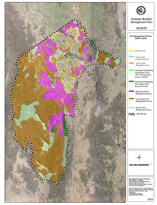
Source: ACT Government 2009b
During the reporting period, an improved Fire Danger Rating system measuring soil moisture deficiency, weather variability, relative humidity, wind, and recent rainfall has been developed. It will enable the ACT Government to improve strategies to prevent and manage bushfires and better alert ACT residents to fire danger.
The Bushfire Cooperative Research Centre has found the "stay or go" policy to be appropriate advice, although there are a number of known limitations to this policy. The policy, with full name Prepare, stay and defend your property or leave early, was first set out in the late 1990s when it was generally accepted by fire agencies that staying to defend a well-prepared home, or leaving for a safe place well before a fire threat appeared, were the two best survival options in a bushfire (Bushfire CRC 2011).
As a result of unpreparedness for the devastating Victorian Black Saturday bushfire in 2009 in relation to "stay or go", the ACT and other jurisdictions have introduced a "catastrophic" warning category into the McArthur Forest Fire Danger Meter, which indicates that affected areas may not be defensible against the threat of bushfires (Rotstein and Webb 2009).
The 2003 ACT fires revealed significant weaknesses in the emergency management of the ACT hospital system and its ability to deliver effective health care in such an emergency. Vulnerabilities were identified in the adequacy of its electricity supply, communication, transport of severely injured people, and preparedness of staff (Rotstein and Webb 2009). The Emergencies (Emergency Plan) 2010 (No1) (ACT Government 2010b) describes initiatives to ensure that improved systems and responses are in place if future large-scale fires occur. While improvements have been made, these will only be fully tested in the event of an emergency.
Monitoring, evaluating and managing fire fuel
A Bushfire Operations Plan is developed each year. It sets out strategies to manage bushfire risk including (ACT Government 2009b):
- fuel management (slashing, controlled burning, grazing, physical removal and treatment of fuel by chemicals);
- access management (construction, upgrade and maintenance of trails);
- infrastructure (such as helipad development and building water tanks);
- equipment purchase;
- training;
- auditing and monitoring;
- planning and research;
- education; and
- response and standby.
In response to a recommendation in the 2007-08 ACT State of the Environment Report, the ACT Government noted that monitoring is ongoing; annual surveys document changes in the structure and composition of vegetation. Additionally, 3 new monitoring sites were established as part of the implementation of the 2009-10 Bushfire Operations Plan and a further 5 sites are marked for development.
Landscape Function Analysis is a technique that is now included in the methods used for monitoring vegetation in the ACT. This technique has been developed for full floristic monitoring and rapid assessment, and it includes a focus on soil characteristics and function. For the newly established monitoring sites, analysis of pre and 1-year post-fire data is not yet available. The results from the previously established Potters Hill (Southern Namadgi National Park) monitoring site have shown that "the prescribed burn had little effect on the vegetation community's composition, but had a noticeable effect on its structure. The structure of vegetation communities is important for fauna, and can be utilised as an indicator of potential habitat" (ACT Government 2010d).
The ACT Planning and Land Authority (ACTPLA, now part of the Environment and Sustainable Development Directorate) also has a bushfire management plan for the urban interface with bushland or grassland and for new urban growth areas (ACT Government 2006). The plan notes that management of the large open space in the ACT must balance bushfire risk mitigation and the planning tradition of Canberra.
The Government has stated that the ACT Planning Strategy (ACT Government 2011) will address the future growth of the city; however, at present there are no proposals to change the existing uses of land currently zoned for forestry (ACT Government 2010d).
The 2007-08 ACT State of the Environment Report recommended determining the long-term use of all forestry land burned in the 2003 bushfire where long-term land uses were not already defined.
See the Threatening processes indicator cluster in the Biodiversity theme, for further information on the effects of fire on biodiversity.
Flood management
Natural and built infrastructure policies can modify the risks of urban flooding. For instance, vegetation along riverbanks can have a beneficial effect on flooding in lowland areas by slowing the rate of water movement (VDSE 2011). Willows along the Molonglo River in the ACT have been thought to help reduce the kinetic energy of flood water, while reducing bank scouring. However, in general, flood risk is reduced by removal of willow trees from the edges of rivers and streams2. In large floods, local flood level is controlled more by constrictions such as bridges and road embankments, that choke the flow down, than by changes to riverbank or instream vegetation (VDSE 2011).
River flooding
The dams and reservoirs in the ACT provide flood storage and attenuation for the river catchments; in particular:
- the Googong Reservoir on the Queanbeyan River is part of the ACT and Queanbeyan water supply network and provides flood storage and attenuation from extreme rainfall in the Queanbeyan River catchment;
- Lake Burley Griffin will provide flood attenuation from future major flooding in the Molonglo River.
- the Cotter River's three large water supply storage reservoirs (Corin, Bendora and Cotter) continue to provide flood mitigation and storage for extreme rainfall events within that river catchment;
- areas along or immediately downstream from the Cotter River which may be affected by flooding in the Cotter River have limited urban development; however numerous associated smaller watercourses can produce localised river flooding within the ACT;
- flood storage and attenuation for the Murrumbidgee River is provided by the Tantangara Reservoir which collects runoff which is then diverted through the Snowy Mountains Scheme, used for the generation of electricity, and then released back into the Murrumbidgee River downstream of the ACT.
The 2007-08 ACT State of the Environment Report recommended that catchment management could be improved by developing an integrated water supply catchment management policy and strategy for the ACT. While the ACT Government noted the recommendation, progress towards a governance structure based on an integrated catchment approach to managing water systems and supply has not yet been fully progressed or implemented (OCSE 2010).
Urban flooding
Both greenfield and infill urban development inevitably increase the area covered by impervious surfaces and the chance of flash flooding from accumulated runoff. This effect is augmented by urban development on previously unallocated open space that had acted to mitigate flash flooding by capturing rainfall. Other flood impacts are associated with higher density development, such as underground car parking.
Managing urban flood risk involves identifying future rainfall patterns, identifying areas that are vulnerable to overland flooding, and changing the design specifications of stormwater systems to accommodate the changed rainfall pattern.
Urban stormwater infrastructure generally comprises minor and major systems. The minor system typically includes kerbs and channels, roadside channels, inlets, underground drainage, manholes and outlets designed manage storm events. A major network is designed to manage rare flood events, and typically includes road pavements, floodway channels and detention basins (ACTPLA 2010).
Flash flooding is mitigated by the urban stormwater system in the ACT. The stormwater system was upgraded after the Woden Valley flood in 1971 and is expected to fully absorb up to a 1-in-10-year event (the likelihood of a flood of a particular size occurring in a particular timeframe is called the average recurrence interval or ARI). This ARI is roughly equal to the return time of major events in La Niña, the climatic system most likely to produce extreme rainfall.
Infrastructure to manage stormwater is designed to safely collect, store, attenuate and discharge stormwater runoff up to a particular ARI design standard. Urban development and community infrastructure along major rivers and floodplains is generally constructed so it should be safe relative to a flood level with a specified ARI. The Government's ACT Design Standards for Urban Infrastructure requires minor urban drainage systems to be designed for a:
- 5-year ARI event in urban neighbourhoods;
- 10-year ARI event for group and neighbourhood shopping centres, industrial areas and service trade areas; and
- 20-year ARI event for town centres and parliamentary areas.
All leased land must be protected against a major storm event up to and including the 100-year ARI design storm event (TAMS 2010).
As part of the ACT Government's strategy to manage urban flooding, Canberra has detention basins (commonly near recreational playing fields), located within all new and some older suburbs (ACTPLA 2010). In addition, impervious water infrastructure is increasingly being coupled with (pervious) Water Sensitive Urban Design, allowing stormwater to be managed through the integration of land-use planning and water management. Water Sensitive Urban Design is applied with the aim of reducing the negative impacts of stormwater on waterbodies and aquatic ecosystems. It involves the capture, filtering and use of stormwater in close proximity to where it falls as rain. In 2006, ACTPLA produced a draft report called Water Sensitive Urban Design: guidelines for sustainable development in Canberra.
During the reporting period a number of wetlands have been constructed in the urban area with the aim of providing a range of benefits including a particular focus on flood and stormwater protection and water quality improvement (see Water quality indicator cluster for further information). These wetlands include:
- Flemington Road Ponds, Mitchell (constructed 2009);
- Banksia St wetland, O'Connor (constructed 2010); and
- Dickson and Lyneham wetlands (construction commenced September 2010).
The ACT Infrastructure Report Card (Engineers Australia 2010) rated the ACT's stormwater infrastructure at C+ in 2010, based on a range of attributes (Table 3). The rating was an improvement from a C rating in 2005.
Table 3. Factors contributing to rating of stormwater infrastructure in ACT, 2010
| Positive | Negative |
|---|---|
| Increased uptake of water sensitive urban design | Lack of a long-term stormwater strategic plan |
| Increased use of stormwater for irrigation | Fragmented governance arrangements for stormwater |
| Achieving required levels of drainage and flood protection in areas developed since the late 1960s | Inadequate levels of drainage and flood protection in older areas of Canberra |
Source: Engineers Australia 2010
Footnotes [top ]
1. The Forest Fire Danger Index helps in estimating the exposure to risk from a bushfire. The scale ranges from an index of 1, where a fire will not burn, to more than 100, where suppression is impossible.
2. Willows at the edges of rivers invade the bed and banks, reducing the size of the stream. This reduces the capacity of the stream to carry flood waters. The result is that willows increase the height of flood waters in small and moderate sized floods (VDSE 2011).
Glossary [top ]
Flash floods: floods that occur and disappear again in a short timeframe following times of heavy rainfall
Flood: a great flowing or overflowing of water, especially over land not usually submerged
Foehn wind: a warm dry wind on the lee side of a mountain range. When humid air goes over a mountain it loses its moisture and cools down, but when it descends the slope the temperature rises because of compression. The result is a strong, warm and dry wind.
Forest Fire Danger Index: provides indices for exposure to risks from bushfires. The scale ranges from an index of 1, where fires will not burn, to more than 100 where suppression is impossible.
Landscape Function Analysis (LFA): a relatively recent technique which has been developed for full floristic monitoring and rapid assessments including focusing on soil characteristics and function
Natural hazards: naturally occurring rapid onset events that cause disruption to a community or region by their impact; a natural hazard can escalate to a natural disaster that threatens or causes death, injury or damage to property or the environment and which requires significant and coordinated multi-agency and community response. Any one, or a combination, of the following can cause such serious disruption to communities, infrastructure and the environment: bushfire; earthquake; flood; storm; cyclone; storm surge; landslide; tsunami; meteorite strike or tornado.
Pyro-convection: deep convection that is triggered or enhanced by large fires, and that can transport gaseous and particulate products into the upper troposphere and lower stratosphere
Suburban fuels: include all of the element in suburbia that contribute to the spread and behaviour of fires through an urban area, such as gardens, mulches, buildings, fences, rubbish, woodpiles
Urban flooding: the result of extreme rainfall over a short duration which can produce large quantities of stormwater runoff in urban areas
References [top ]
ACT Government 2006. Planning for Bushfire Risk Mitigation. Canberra. http://apps.actpla.act.gov.au/tplan/planning_register/register_docs/bushfireguidefeb06.pdf (accessed 29/8/11)
ACT Government 2009a. Strategic Bushfire Management Plan for the ACT - Factors Contributing to Bushfire Risk: Supporting Information: Part One. Emergency Services Agency. Canberra. http://www.esa.act.gov.au/ESAWebsite/content_esa/bushfires/before_a_bushfire/act_sbmp/sbmp_downloads/act_sbmp_supporting_information__part_one.pdf (accessed 31/8/11)
ACT Government 2009b. Strategic Bushfire Management Plan for the ACT. Version 2, 2009. Canberra. http://www.esa.act.gov.au/ESAWebsite/content_esa/bushfires/before_a_bushfire/act_sbmp/sbmp_downloads/act_sbmp_plan_text_web.pdf (accessed 14/1/2011)
ACT Government 2010a. ACT Natural Disaster Resilience Program, Australian Capital Territory Program Guidelines 2010-11. Canberra. http://www.esa.act.gov.au/ESAWebsite/content_esa/about_us/who_we_are/grants/ndrp_program_guidelines.pdf (accessed 23/8/2011)
ACT Government 2010b. Emergencies (Emergency Plan) 2010 .No1. Canberra. http://www.legislation.act.gov.au/ni/2010-571/current/pdf/2010-571.pdf (Accessed 26/8/2011)
ACT Government. 2010c. NUZ4 - River Corridor Zone. Canberra. http://www.legislation.act.gov.au/ni/2008-27/copy/74275/pdf/2008-27.pdf Accessed 28/08/2011 (accessed 28/8/2011)
ACT Government 2010d. Annual Report 2009-10. Office of the Commissioner for Sustainability and the Environment. Canberra. http://www.environmentcommissioner.act.gov.au/__data/assets/pdf_file/0015/205125/OCSE_annual_report_2009-10_final.pdf (accessed 28/8/2011)
ACT Government 2011. Draft ACT Planning Strategy. Environment and Sustainable Development Directorate (ESDD). Canberra. http://www.actpla.act.gov.au/tools_resources/legislation_plans_registers/plans/planning_strategy (accessed 06/12/11)
ACTNRMC. 2009. Bush Capital Legacy - Iconic City, Iconic Natural Assets. Australian Capital Territory Natural Resource Council. Canberra. http://www.actnrmcouncil.org.au/nrmplan/overview/summary (accessed 23/8/2011)
ACTPLA 2010. Human Settlement Vulnerability and Adaptive Management Capacity Assessment: Spatial Plan Evaluation. ACT Planning and Land Authority. Report prepared by AECOM Australia Pty Ltd for ACTPLA. Canberra. http://www.actpla.act.gov.au/__data/assets/pdf_file/0007/20410/2010_09_08_ACTPLA_CCVulnerability_v2_LowResolution.pdf (accessed 21/4/2011)
AG 2011. Caring For Our Country. Australian Government. http://www.nrm.gov.au/nrm/act.html (accessed 23/8/2011)
BoM 2011. Annual Climate Summary 2010. Bureau of Meteorology. Melbourne. http://www.bom.gov.au/climate/annual_sum/2010/AnClimSum10_LR1.0.pdf (accessed 17/11/11)
Bushfire CRC 2008. High Fire Risk Project Stakeholder's Research Report: Evidence-Based Policy for Fire Risk Management In and Around Australia's High Country (draft). Bushfire Cooperative Research Centre. http://www.highfirerisk.com.au/report/hfr_report.pdf (accessed 5/12/11)
Bushfire CRC 2011. Evaluation of "Stay or Go" Policy. Bushfire Cooperative Research Centre. http://www.bushfirecrc.com/projects/c6/evaluation-stay-or-go-policy (accessed 5/12/11)
COAG 2009. National Strategy for Disaster Resilience Building Our Nation's Resilience to Disasters. Council of Australian Governments. http://www.coag.gov.au/coag_meeting_outcomes/2011-02-13/docs/national_strategy_disaster_resilience.pdf (accessed 23/8/2011)
Hennessy, K., Lucas, C., Nicholls, N., Bathols, J., Suppiah, R., Ricketts, J. 2006. Climate change Impacts On Fire-Weather In South-East Australia. CSIRO. Canberra. http://www.cmar.csiro.au/e-print/open/hennessykj_2005b.pdf (accessed 1/10/11)
Dold, J., Weber, R., Gill, M., Ellis, P., McRae, R. and Cooper, N. 2005. Unusual Phenomena in an Extreme Bushfire. 5th Asia-Pacific Conference on Combustion. The University of Adelaide
Doogan, M. 2006. The Canberra Firestorm - Inquests and Inquiry Into Four Deaths and Four Fires. Volume 1. ACT Coroners Court. Canberra http://www.courts.act.gov.au/resources/attachments/The_Canberra_Firestorm_(VOL_I).pdf (accessed 17/11/11)
Engineers Australia 2010. Infrastructure Report 2010: Water. http://www.engineersaustralia.org.au/shadomx/apps/fms/fmsdownload.cfm?file_uuid=C8F26346-DB84-45EF-E104-B53E726D4A61&siteName=ieaust (accessed 18/4/2011)
Fromm, M., Tupper, A., Rosenfeld, D., Servrancx, R. and McRae, R. 2006. Violent Pyro-Convective Storm Devastates Australia's Capital and Pollutes the Stratosphere. Geophys. Res. Lett. 33, L05815.
Fromm, M., Lindsey, D.T., Servranckx, R., Yue, G., Trickl, T., Sica, R., Doucet, P. and Godin-Beekmann, S. 2010. The Untold Story of Pyrocumulonimbus. Bulletin of the American Meteorological Society. September 2010: 1193 - 1209
Geoscience Australia and the Department of Transport and Regional Services. 2007. Natural Hazards in Australia, Identifying Risk Analysis Requirements. http://www.ga.gov.au/image_cache/GA12967.pdf (accessed 19/8/2011)
JACS. 2008. Annual Report 2007-08. Department of Justice and Community Safety. ACT Department of Justice and Community Safety. Canberra http://www.justice.act.gov.au/publication/view/251 (accessed 6/10/11)
JCSD. 2011. Annual Report 20010-11. Justice and Community Safety Directorate. Canberra http://www.justice.act.gov.au/page/view/2645/title/annual-report-2010-11 (accessed 6/10/11)
McRae, R. and Sharples, J. 2011. A Conceptual Framework for Assessing the Risk Posed By Extreme Wildfires. Australian Journal of Emergency Management, 26.2: 47-53
Pyne, S.J. and Omi, P.N. 1986. Wildland Fire and Nuclear Winter - Selected Reconstructions of Historic Large Fires Technical Report. Defence Nuclear Agency. Washington
Rotstein, J. and Webb, B. 2009. Australian Capital Territory and Region Climate Change Vulnerability and Adaptation Project: Knowledge Status and Future Issues Report On Human Health. Version 1.0a. Canberra.
Sharples, J.J. 2009. An Overview of Mountain Meteorological Effects Relevant to Fire Behaviour and Bushfire Risk. International Journal of Wildland Fire. 18: 737-754
Sharples, J.J., McRae, R.H.D., Weber, R.O. & Gill, A.M. 2009. A Simple Index for Assessing Fire Danger Rating. Environmental Modelling and Software 24: 764-774.
Sharples, J., McRae, R, Wilkes, S. Wind-Terrain Effects on the Propagation of Wildfires in Rugged Terrain: Fire Channelling. International Journal of Wildland Fire. in press
TAMS 2010. ACT Design Standards for Urban Infrastructure. ACT Department of Territory and Municipal Services. Canberra. Edition 1, Revision 4 http://www.tams.act.gov.au/__data/assets/pdf_file/0018/12582/ds01_stormwater.pdf (accessed 28/8/2011)
TAMS 2006. Bushfire Operations Plan. ACT Department of Territory and Municipal Services. Canberra. http://www.tams.act.gov.au/play/pcl/fire_management/2010-11_bushfire_operations_plan (accessed 13/6/11)
VDSE 2011. Water in the Environment – Environmental Management. Victoria Department of Sustainability and Environment. http://www.water.vic.gov.au/environment/floodplains/victorian-floods-january-2011/environmental-management
Webb, B. 2011. Impacts of Climate on the Canberra Nature Park: Risks and Responses. Report for the ACT Office of the Commissioner for Sustainability and the Environment. Canberra. http://www.envcomm.act.gov.au/__data/assets/pdf_file/0004/220477/OCSE_ANU_paper_climate_CNP.pdf (accessed 1/12/11)
Other data sources
In addition to these published reports, data for this paper were also sourced from:
- ACT Environmental Protection Agency (EPA) - now part of now Environment and Sustainable Development Directorate (ESDD)


Share this page: