


ACT State of the Environment Report 2011
Accurate, timely & accessible information for the community regarding the condition of the environment, underlying pressures, and sustainability trends.

THEME: Land & Water
Download: Land and Water Theme Paper.pdf
Introduction to Theme
Land and water are the vital and interconnected resources on which all life depends. Land provides a range of ecosystem services, such as soil nutrients, water filtering and habitat, which in turn support food production and settlement. Water is essential for the maintenance and quality of both ecosystems and human settlement. Integrated management of land and water in catchment areas is essential for the health of waterways.
Five Indicator clusters are drawn on for the Land and Water theme:
- Land health
- Rivers, lakes and wetlands health
- Water quality
- Water supply
- Groundwater
Context
The effects of drought and fires dominated assessments of water and catchment health in the 2003 and 2007-08 ACT State of the Environment reports. Conditions have changed in this reporting period, with drought early on and wetter conditions more recently. The need to remain vigilant about the impacts of urban development on water quality and hydrology was highlighted in previous reports and has not diminished. Recommendations from previous State of the Environment reports focused on post-fire rehabilitation to protect catchments and significant steps in post-fire recovery have been made. There has been little change in our knowledge of land health and urban impacts, despite several previous recommendations for improvement.
Data limitations have also been highlighted in previous State of the Environment reports, in particular relating to changes to soil condition, vegetation cover and diversity, and effects of urbanisation on catchments. There are encouraging signs that groundwater data collection and monitoring are improving, though more needs to be done to identify and manage this valuable resource. The need for long-term research and monitoring and for coordinated catchment management remains as valid today as it did when recommended in 2003 and 2007.
The ACT Government is involved in the ongoing restoration and management of the lower Cotter catchment and in the Upper Murrumbidgee Demonstration Reach Project. These are examples of cooperative catchment management activities, and the learnings from these actions should be incorporated into other catchment initiatives. However, previous recommendations to improve cross-boundary catchment management have not been fully realised and require committed action.
Many of these issues remain relevant in this reporting period and recommendations are provided at the end of this paper to assist progress.
Theme Summary: Key issues and outcomes [top  ]
]
Land health, water use, water supply and quality, as well as the health of the ACT waterbodies, were affected by the two distinct phases in climatic conditions between 2007 and 2011 in the ACT. The first phase, from 2007 to May 2010, was dominated by drought, which had a significant impact on the condition of the ACT's land and water resources. The second phase, from June 2010 to June 2011, was associated with a break in the drought and above average rainfall (BoM 2011).
Significant management and infrastructure work has been undertaken to address water security during the reporting period. Climate change will mean that security of water supply will be a challenge for the ACT into the future. Impacts on water quality and water availability are likely, with increasing temperatures leading to increased water demand. The actions taken during the reporting period will provide a strong base for future adaptation.
The health of ACT waterbodies and their water quality are dependent on the land health and land uses of ACT catchments, with waterbodies in urban areas displaying less resilience than those that are non-urban. As identified in previous State of the Environment reports, greater knowledge of the impacts of urban areas on water quality and catchments would be beneficial for future catchment management. With expanding greenfield development increasing the urban footprint in the ACT and increasing density in some areas of the urban area (see the Urban quality indicator cluster), understanding urban impacts on land and water will be essential for effective management.
Land health and erosion
Land use has significant impacts on catchment health and water quality. Land with poor vegetation or groundcover is more at risk of wind and water erosion. As in previous reporting periods, increasing urban development of greenfield sites continues to alter their hydrology. The previous State of the Environment Report recommended monitoring the effects of urbanisation on the ACT region's water catchments and using the information to respond to specific issues. While the ACT landscape, land uses and vegetation have been investigated in several catchments in the ACT, such as the Cotter catchment (ActewAGL 2010), the effects of urbanisation remain a critical area for further examination.
Vegetation mapping is being undertaken and will provide a baseline for future Territory-wide information on change in vegetation cover and quality. It is currently difficult to evaluate land health in the ACT through changes in vegetation. Improving or maintaining vegetation and groundcover in both rural and urban land areas will help to reduce soil loss, and minimise impacts on waterways and catchments. Monitoring can assess the impact of erosion on local land and water resources, and help to detect the interactions between the catchment management and the ecosystem services the catchments produce in the ACT. Erosion potential throughout the ACT was mapped as part of a project to identify the impacts of fuel and fire management activities on soil erosion. This information should also be used by land and catchment managers to ensure a coordinated approach to land health.
The Australian Natural Resource Atlas (2009) suggests that over four million tonnes of sediment is delivered to the Murrumbidgee River from its catchment, which includes the ACT, annually. Most of this sediment entering the Murrumbidgee is derived from gully erosion (51%), a large percentage of which occurs upstream of the ACT (ANRA 2009). Gully erosion is caused by concentrated water flow over non-vegetated surfaces, which removes topsoil and subsoil. The risk of gully erosion is likely to increase, with extreme storm events predicted to occur in the ACT due to climate change (see the Natural Hazards and Climate Vulnerability indicator cluster papers for more information). However, the risk of gully erosion can be decreased through revegetation and other catchment management projects.
Little information is available about the acidity, salinity, carbon storage and overall condition of soils in the ACT. Soil type and soil condition affect land health, and improved knowledge of soil condition and the impacts of land uses on soils will be valuable for effective land management.
River health
The ACT lies within the Murray-Darling Basin (MDB). A Sustainable Rivers Audit was undertaken on the MBD between 2004 and 2007 to assess the ecological health of rivers in the Basin. It found the Murrumbidgee River was generally in 'very poor' condition (MDBA 2008). However, it is acknowledged that this audit was undertaken following the 2003 bushfire, which may have had severe impacts on some of the water quality monitoring sites.
Generally, river health and catchment condition are improving within the ACT. In recent years rivers and streams have been stressed by the extreme events of drought and fire. Sites outside the urban area have displayed resilience and appear to be recovering from the impacts of the 2003 bushfires. This is a result of the re-established vegetation within the catchments and the improvements in riparian zones following the bushfires (ACT NRMC 2009). As in previous reporting periods, the urban area continues to have a large impact on the health of the catchments and quality of river water in the ACT.
Riparian vegetation influences river quality and aquatic ecosystems through filtering out sediments and nutrients from incoming runoff and by providing bank stability and in-stream habitat (e.g. tree roots, fallen logs, shade).
Over the reporting period, average nutrient concentrations within ACT's rivers were generally within the limits specified by Environmental Protection Regulations (DECCEW 2010a), but there were some exceedances. However, suspended solids within a number of the lakes and waterways exceeded the limit of 25 mg/L on a number of occasions. This may be because large rainfall events generated increased stormwater run-off after the drought broke in 2010.
Lake health
ACT lakes and ponds continue to have high concentrations of chlorophyll 'a', especially in warmer months. Chlorophyll 'a' is an indicator of photosynthetic microorganisms present in aquatic ecosystems, of which the potentially toxic blue-green algae or cyanobacteria are of most concern. Blue-green algae cell counts are carried out when sampling records a spike in chlorophyll 'a' readings at a particular location, or when large amounts of blue-green algae have been visually identified, in accordance with the ACT Guidelines for Recreational Water Quality (ACT Health 2009).
During the reporting period, sampling in ACT lakes measured elevated concentrations of chlorophyll 'a' and sporadic high or extremely high concentrations of blue-green algae. This occurred primarily between spring and autumn of each year when these waterbodies had correspondingly higher concentrations of available nutrients and relatively warm waters. Summer incidence of blue green algae in ACT lakes appears to be increasing. This is when lakes are most likely to be used for recreation. Over the last ten years, there has been a steady increase in the number of lake closures per year, because of either faecal contamination or potentially toxic blue-green algae in the water. Between 2007 and 2011 there were several instances of elevated concentrations of algae and pathogens in ACT lakes, which resulted in a number of human health alerts and lake closures. Greater focus is needed on the management of ACT lakes to improve water quality so that recreation activities are not restricted.
The National Capital Authority was alerted to discharges of partially treated effluent from the Queanbeyan Sewage Treatment Plant entering the Molonglo River on 3 December and 8 December 2010. The discharges resulted in complete closure of Lake Burley Griffin to all recreational users, to avoid risks to human health. Also contributing to this closure were significant quantities of debris travelling down the Molonglo River into the lake following major flood events during the same period (NCA 2011).
Wetland health
Of the ACT's wetlands, 13 are listed in the national Directory of Important Wetlands in Australia (DSEWPaC 2009). One of them, the Ginini Flats Wetland Complex (made up of a series of interconnected flats known as Ginini Flats and Cheyenne Flats) in Namadgi National Park, is listed as a Ramsar site. Wetlands provide water filtering and groundwater recharge, and the Ginini Flats wetlands in particular help maintain streamflow into Canberra's domestic supply as well as providing habitat for a number of threatened species.
Information on the health of ACT wetlands is patchy with few projects surveying riparian health and water quality. Wetland health has been variable in those that have been surveyed. One of the challenges for management of wetlands is the individuality that characterises each wetland (Johnston et al. 2009).
During the reporting period wetlands have been constructed in urban areas across the ACT to improve the quality of stormwater. These wetlands reduce the quantity and velocity of peak flows in urban streams by capturing stormwater. Slowing water flow in the wetlands allows solids to settle out. Wetlands plants also bind phosphorus and nitrogen that are in the water, removing these contaminants (DECCEW 2011) so that the water leaves the wetland cleaner than it was when it entered.
Water use and drought
The recent drought had a significant impact on water resources. Water storage levels within the ACT were less than 40% of capacity in 2007-08. However, the significant rainfall in late 2010 increased the ACT's water supplies to 100% capacity (Figure 1). This marked the first time since 2000 that all ACT's water supply dams were more than 80% full.
Figure 1: Water storage levels between January 2007 and March 2011
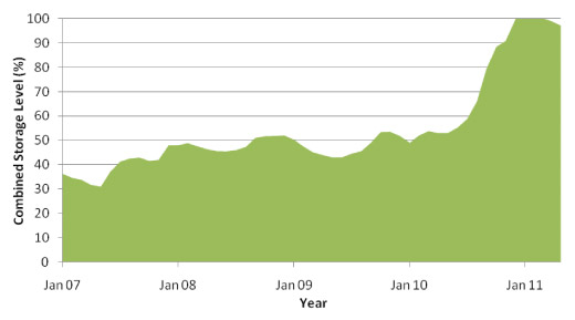
Source: ACTEW 2011a
Between 2005-06 and 2009-10, potable water use within the ACT decreased by approximately 7 GL per year (Figure 2), primarily because of a decrease in household water use. Household water use, the main use of water in the ACT (66.3%), decreased by 17% between 2006-07 and 2009-10 in response to the drought and associated water conservation measures. As ACT residents have only recently been allowed to adopt the more relaxed Permanent Water Conservation Measures, it is yet to be seen whether water-efficient behaviour is now embedded in the behaviour of Canberrans, or if water use will once again increase.
Figure 2. Total water use within the ACT
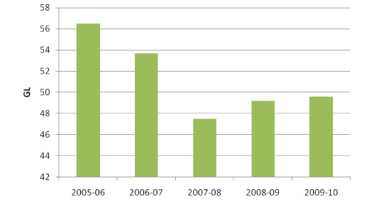
Source: ActewAGL 2010
Groundwater is an important localised water resource for the ACT, although it contributes only a small proportion of the overall water supply. Over-extraction could affect the health of groundwater-dependent ecosystems, and the continuing availability of groundwater for human use. Groundwater abstractions are limited to 10% of long-term recharge, and actual abstractions remain small. Improved monitoring of groundwater should provide greater knowledge and understanding of groundwater in the ACT.
Responses and effectiveness [top ]
Catchment management
A number of catchment management projects were implemented during the reporting period to improve the overall health of ACT's land and water resources. Catchment management is the management of land and water resources across a catchment. Catchment management can be used to minimise the risk of, and repair land affected by, erosion and other forms of land degradation.
The previous ACT State of Environment Report made a number of recommendations to improve catchment quality in the ACT relating to catchment management and the restoration of the Lower Cotter Catchment. In the Lower Cotter Catchment, a major restoration project has been undertaken to rehabilitate and restore native vegetation. The project is one of the largest land rehabilitation projects undertaken in Australia, and it involves the replanting of native vegetation on over 3500 hectares of former pine plantation destroyed by the 2003 bushfire (TAMS 2006). The project also aims to control weeds such as pine seedlings and blackberries, and also involves replanting native vegetation, managing fire risk, conducting monitoring and promoting natural regeneration. Native vegetation is now one of the most desirable land uses within the catchment; it should help improve soil stability and minimise erosion risk (TAMS 2006).
Maintenance and management of the roads and trails has also been undertaken within the Lower Cotter Catchment due to their identification as major sites of erosion, responsible for movement of sediment into watercourses and eventually the Cotter Dam (TAMS 2006). Many of the roads and trails needed for the management of the pine plantation are no longer required. As a result, these roads have been closed and rehabilitated. The remaining roads needed for land and fire management have been upgraded to minimise erosion risk.
Wetland management
As mentioned above, one of the challenges in managing wetlands is the variation of characteristics of each wetland (Johnston et al. 2009). A number of the sphagnum bogs burnt in the 2003 fires in the Cotter Catchment have been rehabilitated to prevent stream entrenchment and drainage and loss of the bogs. At the Jerrabomberra Wetlands near Lake Burley Griffin, the Jerrabomberra Wetlands Nature Reserve Plan of Management (TAMS 2010) has been completed, and willows and woody weeds have been controlled. The Capital Woodland and Wetlands Conservation Trust is being established to support projects in Jerrabomberra Wetlands Nature Reserve and Mulligans Flat Woodland Sanctuary. The Trust is intended to supplement rather than replace annual government support for normal ongoing management of these areas (OCSE 2011). For more information see the Fauna indicator cluster paper (Biodiversity theme).
Water quality
Water quality in the ACT's lakes and rivers is affected by the land use upstream in both the ACT and in NSW. Cross-boundary catchment management projects are continuing, with the aim of improving catchment condition and water quality within the ACT. For example, the Upper Murrumbidgee Demonstration Reach (UMDR) initiative focuses on approximately 100 km of the river, extending from the rural township of Bredbo in south-eastern NSW downstream to Casuarina Sands in the ACT. The UMDR initiative aims to provide the community with a visible demonstration that the health of the river, floodplain and wildlife depends upon aquatic habitats, and that these habitats can be restored to a better condition through coordinated actions that address the major threats. The UMDR initiative involves a suite of river rehabilitation methods, and complements other plans and activities that are ongoing under other programs (ACT Government 2010).
Another example is the current multi-jurisdictional investigation of the state of the waterways entering Lake Burley Griffin (commenced in June 2011), by the Commissioner for Sustainability and the Environment. The findings of this investigation will identify and recommend ways to improve management of the waterways and catchment.
Local water quality can also be improved through the implementation of Water Sensitive Urban Design initiatives, such as constructed wetlands, ponds and rain gardens. These initiatives aim to provide amenity to the urban landscape, whilst also improving and enhancing water quality within the urban environment. Since 2008, the ACT Government has constructed a number of new urban wetlands. Several are in the Sullivans Creek Catchment, including the Banksia Street wetland, as part of the Canberra Integrated Urban Waterways project (DECCEW 2011) to improve the creek's water quality. The Banksia Street wetland captures the local stormwater and naturally treats the water to improve its quality, before it flows back into the stormwater network and eventually into Sullivans Creek.
The Canberra Integrated Urban Waterways project focuses on integrating stormwater and urban waterways, by investigating opportunities such as stormwater harvesting and injection to groundwater storages by managed aquifer recharge. By the end of 2011, the ACT Government aim to save 1.5 GL of potable water by using water from wetlands constructed along Sullivans Creek instead of the potable supply to irrigate local sportsfields. By 2015, the project aims to substitute 3 GL per year of potable water in this way (DECCEW 2010a).
The previous ACT State of the Environment Report recommended developing an integrated water supply catchment management policy for the ACT, as well as a strategy to guide, among other things, coordination of scientific research, data collection, monitoring and reporting (including public information). While some projects such as the Canberra Integrated Urban Waterways project and the Upper Murrumbidgee Demonstration Reach initiative have demonstrated such an approach, catchment management in the ACT is still conducted by a number of different actors and agencies, creating challenges for an integrated approach. The ACT Government's review of the Think water, act water strategy (ACT Government 2004, DECCEW 2010b), is an appropriate forum to improve integration of research, monitoring reporting and policy and therefore strengthen water and catchment management in the ACT.
Community groups continue to play a significant role in the monitoring and management of the lakes, rivers and catchments of the ACT. Catchment Management Groups and Parkcare and Landcare groups undertake waterway and land-based conservation, management and restoration in ACT catchments, while Frogwatch and Waterwatch groups raise awareness and monitor and conserve ACT waterways and their inhabitants.
Water security and efficiency
The ACT has been investigating and developing new water supplies in response to increased climate variability, drought, increasing population and water demand. A number of water supply enhancement projects have been implemented, including three major projects initiated during the reporting period (ACTEW 2011b, ICRC 2011):
- enlarging the Cotter Dam;
- pumping water from the Murrumbidgee River to Googong Dam to supplement the ACT's water supply; and
- purchasing general and high security water entitlements for the Tantangara Transfer project.
Stage 3 water restrictions were in place throughout much of the reporting period, but were gradually relaxed in late 2010 following significant rainfall. Permanent Water Conservation Measures remain in place to maintain water conservation efforts. The Think water, act water strategy set targets of a reduction in per capita water consumption of 12% by 2013 and 25% by 2023 compared with 2003 levels. These targets are to be met through water efficiency measures to reduce potable water use by recycling and use of stormwater, rainwater and recharging of aquifers for irrigation and other uses.
Water efficiency programs, including showerhead rebate and water tune-ups, have continued to be implemented during the reporting period. The residential water efficiency programs collectively accounted for approximately 1.22 GL (or around 11%) of demand management savings in 2008-09 (DECCEW 2010b). In 2008-09 demand management and water efficiency measures are credited with having saved 11.36 GL of water, equating to 16.5% of the expected baseline consumption of the ACT community (DECCEW 2010b).
Based on information from the Australian Water Resources Assessment (NLWRA 2000), groundwater management in the ACT is largely effective. However, it will be important to continue to improve understanding of 'at risk' aquifers, in particular, and manage impacts on groundwater quality from contaminated sites. In response to increasing demand for and use of groundwater, the ACT Government has also been targeting improvements in the accuracy of groundwater assessments and broadening groundwater monitoring. Monitoring of groundwater recharge will be a valuable contribution to understanding and quantifying of potential effects of changed rainfall patterns expected as part of climate change (as discussed in the Climate Vulnerability indicator cluster paper).
Emerging issues [top ]
Cross-boundary catchment management, including the impact of upstream land uses in NSW on the Murrumbidgee River, continues to be problematic and increasingly important. Cross-boundary catchment management issues relating to the Googong Dam were identified in the 2007 State of the Environment report; a significant portion of the catchment lies within NSW. These cross-boundary issues can also relate to areas within the ACT, and occur at both state and federal levels. For example, Lake Burley Griffin is managed by the National Capital Authority (NCA), but is used mainly by Canberrans; and the Murrumbidgee River passes through the ACT but is affected by upstream water quality factors in NSW.
Cross-boundary catchment management is challenging. Management arrangements to facilitate cooperation on land and water issues are in place. However strengthening integrated management action would be beneficial. Integration might be helped by improved exchange and use of information, such as spatial information, between government agencies, Natural Resource Management groups and Catchment Management Authorities, and by promoting sustainable catchment management with landholders and the community.
Recent CSIRO research indicates that soil carbon is increasingly becoming an important land management issue. Soil can store more carbon than plants and the atmosphere combined and can therefore assist in mitigating climate change. In future, land capability assessment is likely to need to take account of this stored carbon (ACT NRMC 2009).
The Water Sensitive Urban Design treatments implemented during the reporting period will require ongoing maintenance to remain effective in improving local stormwater quality. Planning for and implementing this maintenance is a challenge facing many authorities in urban Australia (Water Sensitive Cities 2009) and is likely to remain important also within the ACT.
Recommendations [top ]
-
Establish cross-boundary management of the ACT’s water resources including:
- developing catchment policy and an integrated water supply catchment management strategy, as recommended in previous State of Environment reports; and
- strengthening integrated management action by facilitating improved exchange and use of information, such as spatial information, between government agencies, Natural Resource Management groups and Catchment Management Authorities, and by promoting sustainable catchment management with landholders and the community.
- Complete assessment of the ACT’s at risk groundwater resources.
-
Update water management, monitoring and reporting programs to inform:
- actions to mitigate the impacts of urban development on water quality;
- the efficacy of Water Sensitive Urban Design measures;
- improvements in sediment and erosion mitigation actions; and
- management of ACT lakes.
-
Improve monitoring to assess the impact of erosion on local land and water resources, and to help to understand the interactions between the ACT's catchment and ecosystem services in particular:
- undertake baseline soils mapping for the ACT to facilitate monitoring and assessment of soil condition;
- identify indicators of land health including soil heath, vegetation quality and change and land use changes; monitor and publicly report on these on a regular basis;
- improve limited land health data by including land health assessments in water catchment data to inform soil condition across the ACT; and
- improve actions related to sediment and erosion mitigation.
- Management of knowledge and the coordination of scientific research, data collection, monitoring and reporting (including public information) is an area of concern across all themes. A specific recommendation to address this is provided under the recommendations section of the Biodiversity Theme paper.
References [top ]
ACT Government 2004. Think Water, Act Water Strategy. Canberra. http://www.thinkwater.act.gov.au/permanent_measures/the_act_water_strategy.shtml (accessed 20/7/11)
ACT Government 2010. Upper Murrumbidgee Demonstration Reach Implementation Plan. Canberra
ACT Health 2009. ACT Guidelines for Recreational Water Quality. ACT Government. Canberra. http://www.health.act.gov.au/c/health?a=sendfile&ft=p&fid=1281404492&sid= (accessed 31/8/11)
ACT NRMC 2009. Bush Capital Legacy - Plan for Managing the Natural Resources of the ACT. ACT Natural Resource Management Council. Canberra. http://www.actnrmcouncil.org.au/files/NRMplan.pdf (accessed 19/7/11)
ACTEW 2011a. Our Projects. ACTEW Corporation Ltd. Canberra. http://www.actew.com.au/Our%20Projects.aspx (accessed 12/7/11)
ACTEW 2011b. Water Storage Levels. ACTEW Corporation Ltd. Canberra. http://www.actew.com.au/water/damlevels.aspx (accessed 26/5/11)
ActewAGL 2010. Annual Drinking Water Quality Report 2009-10. ACTEW AGL. Canberra. http://www.actewagl.com.au/Environment/~/media/ActewAGL/ActewAGL-Files/Environment/water-quality-report.ashx (accessed 30/11/11)
ANRA 2009. Soils - Australian Capital Territory. Australian Natural Resources Atlas. Commonwealth Government. Canberra. http://www.anra.gov.au/topics/soils/erosion/act/index.html (accessed 19/7/11)
BoM 2011. Annual Australian Climate Statement 2010. Bureau of Meteorology. Commonwealth Government. Canberra. http://www.bom.gov.au/announcements/media_releases/climate/change/20110105.shtml (accessed 19/7/11)
DECCEW 2010a. ACT Water Report 2009-10. Department of the Environment, Climate Change, Energy and Water. ACT Government. Canberra http://www.environment.act.gov.au/__data/assets/pdf_file/0008/227978/DECCEW_Water_Report_WEB.pdf (accessed 30/11/11)
DECCEW 2010b. Think Water, Act Water: 2009 Demand Management Progress Report. Department of the Environment, Climate Change, Energy and Water. ACT Government. Canberra. http://www.thinkwater.act.gov.au/permanent_measures/documents/2009ProgressReport1_web.pdf (accessed 24/11/11)
DECCEW 2011. Constructed Wetlands. Department of the Environment, Climate Change, Energy and Water. ACT Government. Canberra. http://www.environment.act.gov.au/water/constructed_wetlands (accessed 19/6/11)
DSEWPaC 2009. A Directory of Important Wetlands in Australia, 3rd edition. Department of Sustainability, Environment, Water, Population and Communities. Commonwealth Government. Canberra. http://www.environment.gov.au/water/publications/environmental/wetlands/pubs/directory.pdf (accessed 20/11/11)
ICRC 2011. Licensed Electricity, Gas, Water and Sewerage Utilities: Compliance and performance report for 2008-09. Independent Competition and Regulatory Commission. ACT Government. Canberra. http://www.icrc.act.gov.au/__data/assets/pdf_file/0005/228776/Compliance_and_Performance_Report_2008-09.pdf (accessed 31/8/11)
Johnston, L., Skinner, S., Ishiyama, L. and Sharp, S. 2009. Survey of Vegetation and Habitat in Key Riparian Zones: Murrumbidgee River, ACT. Technical Report 22.Conservation, Planning and Research Land Management and Planning Division. Department of Territory and Municipal Services, ACT Government. Canberra
MDBA 2008. Sustainable Rivers Audit 2004-2007. Murray-Darling Basin Authority. Commonwealth Government. Canberra. http://www.mdba.gov.au/programs/sustainable-rivers-audit (accessed 12/7/11)
NCA 2011. Lake Burley Griffin Water Quality Management Fact Sheet. National Capital Authority. Commonwealth Government. Canberra. http://www.nationalcapital.gov.au/haveyoursay/attachments/article/143/LBG_Water_Quality_Management_Factsheet.pdf (accessed 25/11/11)
NLWRA 2000. Australian Water Resources Assessment. National Land and Water Resources Audit. Commonwealth Government. Canberra. http://www.anra.gov.au/topics/water/pubs/national/water_contents.html (accessed 30/11/11)
OCSE 2011. Report on the Investigation into the Canberra Nature Park (nature reserves); Molonglo River Corridor (nature reserves) and Googong Foreshores. Office of the Commissioner for Sustainability and the Environment. Canberra. http://www.environmentcommissioner.act.gov.au/__data/assets/pdf_file/0006/234987/Part_I_Report.pdf (accessed 30/11/11)
TAMS 2006. Lower Cotter Catchment. Department of Territory and Municipal Services. Act Government. Canberra. http://www.tams.act.gov.au/play/parks_conservation_and_lands/parks_reserves_and_open_places/water_catchments/lower_cotter_catchment (accessed 19/7/11)
TAMS 2010. Jerrabomberra Wetlands Nature Reserve Plan of Management 2010. Department of Territory and Municipal Services. ACT Government. Canberra. http://www.tams.act.gov.au/__data/assets/pdf_file/0018/207306/WEB_Jerrabomberra_MP.pdf (accessed 21/11/11)
Water Sensitive Cities 2009. Evaluating Options for Water Sensitive Urban Design - A National Guide. Joint Steering for Water Sensitive Cities. http://www.environment.gov.au/water/publications/urban/pubs/wsud-guidelines.doc (accessed 19/7/11)
Other data sources
In addition to these published reports, data for this paper were also sourced from:
- ACT Department of the Environment, Climate Change, Energy and Water (DECCEW) - now Environment and Sustainable Development Directorate (ESDD)
- ACT Environmental Protection Agency (EPA) - now part of now Environment and Sustainable Development Directorate (ESDD)


Share this page: