


ACT State of the Environment Report 2011
Accurate, timely & accessible information for the community regarding the condition of the environment, underlying pressures, and sustainability trends.
THEME: Land and Water
Indicator cluster: Land health [top  ]
]
Download: Indicator cluster: Land Health.pdf
The Land health indicator cluster covers eight indicators, including:
- Soil condition (C) - the extent, distribution and condition of soil classes, soil salinity and soil carbon;
- Vegetation and ground cover (C) - extent and distribution of vegetation and ground cover;
- Erosion (P) - extent, distribution and type of erosion and soil loss;
- Soil acidity (P) - extent and distribution of soil acidity;
- Contaminated sites (P) - extent and distribution of contaminated sites;
- Catchment management (R) - effectiveness of catchment management responses in the ACT;
- Natural Resource Management (NRM) Plan (R) - effectiveness of the ACT NRM plan; and
- Contaminated site management (R) - effectiveness of contaminated site management and remediation.
Condition indicators (C) present data that tell us the state of the environment at any particular time.
Pressure indicators (P) present data about the main human activities that could potentially adversely affect the condition of the environment.
Impact indicators (I) present data on the effect that environmental changes have on environmental or human health.
Response indicators (R) present data about the main things we are doing to alleviate pressures, or to improve the condition of the environment.
Summary [top ]
Most ACT soil is infertile and has a high potential for water logging and erosion. However, there is little recent information available about the extent and locations of land in the ACT affected by soil erosion or soil acidity, nor about the factors contributing to land health. Improved data collection and monitoring of changes to natural resources in the ACT would be beneficial.
While over 50% of the land is managed as conservation areas, no data are available on the change in vegetation condition over time across the whole of the ACT.
The ACT Government and community organisations have undertaken a range of catchment management activities over the reporting period, 2007-2011. In particular, the lower Cotter catchment has been the site of a major project to rehabilitate and replant native vegetation to areas previously given over to plantation forestry. This catchment area is expected to have greater soil stability and a lower risk of erosion as a result of this project.
During the reporting period the ACT Government undertook intensive remediation of groundwater contaminated by a hydrocarbon plume, and facilitated the remediation of soil from this and other contaminated sites.
Introduction [top ]
Land health is important for maintaining a range of ecosystem services including soil nutrients, water filtering, and habitats that support ecosystems and human settlement. Important factors contributing to land health in the ACT include soil condition, vegetation and ground cover. Pressures that impact on ACT land health include soil erosion, soil salinity and acidity, and contamination of land.
Condition indicators [top ]
Soil condition
Soil condition in the ACT is important for landscape health and ensuring the productivity of land for agriculture and other uses. Soils overall can hold more carbon than plants and the atmosphere combined. The carbon is in the form of decaying plant matter, soil organisms and microbes, and minerals in the soil. Management of soil carbon storage can assist in mitigating climate change.
ACT soils are highly variable, with most being infertile (ACT NRMC 2009). There are five dominant orders of soil in the ACT (ASRIS 2011):
- Chromosols: these soils have an abrupt increase in clay content below the top soil;
- Kandosols: these soils are massive and earthy;
- Kurosols: these soils have an abrupt increase in clay content from the top soil to subsoil and at depth they are strongly acidic;
- Sododols: these soils have an abrupt increase in clay content from the top soil to subsoil, with the subsoil being high in sodium; and
- Tenesols: these are sandy soils that are generally shallow.
Most (64%) of the Canberra urban area is built upon the Williamsdale soil type, which has a high potential for water logging, and is moderately to highly susceptible to erosion under non-concentrated and concentrated water flows (Jenkins 2000).
There is limited information on the extent of soil salinity, the storage of soil carbon, and the overall condition of soils in the ACT. The impacts of salinisation - including dryland, irrigation and urban salinisation - are evident across many rural areas in the major catchments surrounding the ACT as well as in the Murrumbidgee River catchment.
Soils in urban areas are also likely to be negatively affected by land use as well as by practices such as continuous and extensive application of greywater. Urban land is also quite likely to become contaminated (see Impact indicator below). However, only limited information is available on the impacts of pollutants on ACT urban soils, and more detailed studies are required to determine the extent of these impacts.
Vegetation and ground cover
Vegetation maps recently compiled by TAMS indicate that the primary land cover in the ACT conservation areas is woodland and forest. Vegetation and ground cover in the ACT are closely linked to land use (Figure 1), particularly because over 50% of the land is managed as conservation areas and approximately 20% used for rural production. The remainder is largely urban. While intensive agriculture and horticulture are conducted in some areas, the dominant rural land use is grazing (ACT NRMC 2009).
Figure 1. Land use in the ACT
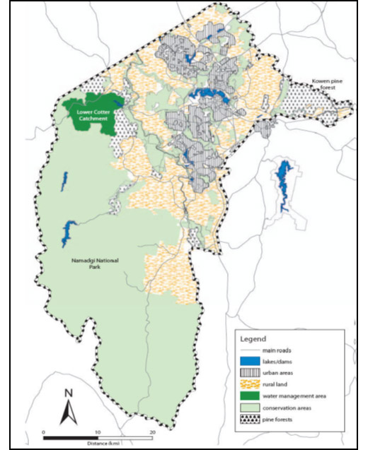
Source: ACT NRMC 2009 (Map: Territory and Municipal Services)
No data are available on the change in vegetation condition over time across the whole of the ACT. However, research currently underway is classifying and mapping the distribution of ACT vegetation communities. This work will set a baseline of information about current vegetation communities, and is likely to identify and classify additional vegetation communities to those already listed. For more information on vegetation condition in the ACT see the Ecological communities indicator in the Biodiversity theme.
A landscape-function analysis of 34 nature reserves and one potential reserve was part of a recent investigation into Canberra Nature Park (nature reserves); Molonglo River Corridor (nature reserves) and Googong Foreshores (OCSE 2011a). Landscape function condition was defined for each sample, based on three assessments: the measured landscape function; scores for bushland health, and on-site observation of a range of landscape condition values (including weediness, amount of bare ground, and soil disturbance) (Sharp 2011). This analysis (OCSE 2011a) indicated that:
- one nature reserve, Mount Painter, is in a critical condition;
- 17% are approaching a critical condition; and
- 80% are in overall satisfactory condition.
Even though most of the nature reserves in ACT were assessed as being in satisfactory condition, there are localised areas within these nature reserves that were assessed as being in critical condition or approaching critical condition (OCSE 2011a). This included a number of reserves with very high nature conservation values, in particular (Sharp 2011):
- Callum Brae, Gungaderra (woodland), Kinlyside, Tuggeranong Hill, Wanniassa Hills and West Jerrabomberra, where between 20% and 50% of the reserve area was approaching critical or in critical condition; and
- Googong Foreshores, Goorooyarroo, Mulligans Flat and Red Hill, where more than 50% of the reserve area was approaching critical or in critical condition (Sharp 2011).
The combined area of those reserves assessed as in overall critical condition or approaching critical condition covers about 4200 hectares (OCSE 2011a).
The urban area of Canberra includes significant vegetation. Nature reserves, together with street and park trees, form a major part of Canberra's green infrastructure, providing essential ecosystem services and supporting the Territory's economic and social systems and biodiversity. They provide important connectivity along routes for species' movements (see Biodiversity theme). The dominant vegetation types in ACT urban areas are introduced species, in gardens and as grassland, plantation trees and street trees.
Weed infestations are an issue in some parts of the ACT, often in areas in which the native vegetation has been suppressed. Where introduced pasture species are heavily grazed, there is an increased risk of weeds becoming established, such as Paterson's Curse (Echium plantagineum), Saffron Thistle (Carthamus lanatus), and St John's Wort (Hypericum perforatum). For further information on weeds, refer to the Threatening processes indicator in the Biodiversity theme.
Land that has poor vegetation or ground cover is more at risk of erosion by wind or water. Improving vegetation condition and ground cover should help to reduce soil loss, and minimise impacts on waterways and catchments in the ACT. For further information, refer to the Ecological communities indicator cluster in the Biodiversity theme.
Cotter catchment
A large part of the Cotter River catchment is in Namadgi National Park. The catchment covers approximately 50,000 hectares and its vegetation is a mixture of sub-alpine wet and dry forests, perched swamps and valley floor grasslands (ACTEW 2009). In the areas of the catchment where native vegetation is dominant, the prevalent land cover is forest, open forest or woodland, with smaller areas of closed forest communities, and grasslands.
In contrast, the lower Cotter catchment is highly modified as a result of its past land use, in particular for Radiata Pine plantations. Weeds in the lower Cotter catchment forestry estate continue to be a problem (ACTEW 2009).
Vegetation in the Cotter catchment was significantly affected by the 2003 bushfires, but native vegetation has started to re-establish, especially in the upper Cotter catchment. Extensive plantings by community volunteers have also helped the re-vegetation process (see Catchment management section below and the Community engagement paper) in the lower Cotter catchment, but there are still some areas that have little vegetation and ground cover and are susceptible to erosion. The vegetation in these areas is in relatively poor condition, with introduced and weed species evident.
Googong water supply catchment (in NSW)
The catchment of the Queanbeyan River (in NSW) is an important part of the ACT water supply because it provides the water stored by the Googong Dam. The catchment has had a wide range of land uses, many of which have the potential to affect the condition of the landscape and the water quality in the river systems.
Over 30% of the catchment is used for agriculture and grazing. Plantation forestry is the second most common land use, although much of the pine forest continues to be essentially unmanaged (ActewAGL 2011). The catchment has significant wooded areas, including the Tallaganda, Yanununbeyan and the Gourock National Parks.
Pressure indicators [top ]
Vegetation clearing and overgrazing (removing ground cover) can significantly affect land health through facilitating soil erosion and loss of soil nutrients. Some types of erosion and nutrient loss occur through natural movement of soil by wind and water. However land can be degraded as a result of human activities such as urban development, some agricultural practices, or poor land management practices. Many types of land degradation, such as soil loss resulting from accelerated erosion and dryland salinity, have long-term or irreversible consequences for species and ecosystems and production. As identified in previous ACT State of the Environment Reports, limited information is available on the extent of land degradation in the ACT and how it changes over time.
The investigation into Canberra Nature Park (nature reserves); Molonglo River Corridor (nature reserves) and Googong Foreshores (OCSE 2011a) identified a number of disturbance factors observed as adversely affecting the condition of some nature reserves, including:
- clearing of native vegetation;
- grazing pressure and soil disturbance by herbivores;
- weed infestations, erosion and bare soil;
- impacts from fire events (operational burns and wildfires) and other bushfire operations; and
- impacts resulting from use by visitors and the maintenance of infrastructure within nature reserves.
The impacts of these factors are discussed in detail in the Biodiversity theme and Threatening processes indicator cluster.
Erosion
As noted above, soil erosion is a natural process that can be accelerated by inappropriate land use. Increased rates of erosion can result from deforestation, overgrazing, urban development and agricultural practices. Soil erosion can significantly reduce the health and productivity of land resources and waterways in the ACT.
Key forms of soil erosion affecting the ACT are:
- sheet erosion, caused by rain and water flows that remove topsoil and reduce the productivity of agricultural land; when soil enters waterways it affects water quality and habitat quality for aquatic ecosystems and species;
- gully erosion, caused by concentrated water flow that removes topsoil and subsoil; reduces land management options; negatively impacts on water quality, aquatic condition and biodiversity; and may become more prevalent if extreme storm events are associated with climate change; and
- wind erosion that removes exposed soil; reduces land productivity and air quality; and may become more common with climate change and extreme storm events.
Erosion potential has been mapped for the whole of the ACT as part of a project to identify the impacts of fuel and fire management activities on soil erosion (Figure 2). Some individual catchments and forestry estates have also been assessed and mapped for erosion risk: for example, the Lower Cotter Forestry Estate in 2008 (Ecowise Environmental 2008). Areas of high erosion risk may also be a high risk for water quality.
Figure 2. Erosion risk in the ACT
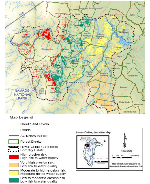
New Figure 2 [top ]
Source: ESDD
Soil acidity [top ]
Soil acidification can reduce soil health and productivity. Acid dryland soils are those having a pH below 5.5 (when measured as 1:5 soil:water as defined for NSW Government State of the Environment reporting (NSW DECCW 2003). Leakage of nitrate below the root zone, oxidation of ammonium fertilisers, accumulation of soil organic matter, and export of plant and animal products from the land have been identified as the four main acidifying processes (Lockwood et al. 2003).
If left unchecked, soil acidification reduces pasture and crop growth, and can lead to a decline in vegetative cover and agricultural production. As soil acidity becomes more severe, its impacts begin to extend beyond agricultural production, contributing to impacts on groundwater recharge and pollution, and reducing water quality in catchments.
Overall there is limited information regarding soil acidity in the ACT. There are no recent data to indicate whether or not soil acidity is increasing in the ACT.
Contaminated sites
Contaminated land is land that is polluted by a hazardous substance that can pose a risk to the environment or human health. Land contamination can occur as a result of poor environmental management and waste disposal practices and spills from industrial and commercial activities. Managing the location and use of these potentially contaminating activities is critical to the control of contaminated sites in the ACT.
In the ACT between 2007 and 2011, 147 new contaminated sites were identified (Table 1), increasing the total reported contaminated sites in the ACT from 752 to 899. The sites have become contaminated during use as, for instance, sheep dips, service stations and other fuel storage sites, municipal landfills and uncontrolled fill sites. Each of these sites has the potential to cause land and groundwater contamination. The 2007-08 ACT State of the Environment Report reported 754 contaminated sites, but that number has been revised down to 752 because sites were incorrectly counted in the previous reporting period.
Table 1. Contaminated sites identified between 2007 and 2011
| Type | Number |
|---|---|
| Hydrocarbon sites | 95 |
| Landfill sites | 20 |
| Cattle/Sheep dip sites | 1 |
| Other sites | 31 |
| Total | 147 |
Source: ACT Environment Protection Authority
The majority of the 95 hydrocarbon sites were identified as a result of redevelopment of commercial sites and during the Department of Education and Training fuel tank removal program. The majority of the 20 landfill sites were associated with uncontrolled fill identified in greenfield development sites. One new cattle dip was identified by the ACT Government Vet during the reporting period. The 31 other sites include former Parks and Gardens depots, defence sites and commercial storage facilities.
Fuel storage and uncontrolled landfill are the two most common uses associated with contaminated sites that required assessment and remediation. Fuel storage at a number of former service stations, subject to redevelopment over the reporting period, had resulted in identified hydrocarbon impacts to both soil and groundwater, requiring remediation. Also, as identified in previous ACT State of the Environment Reports, a hydrocarbon plume is present in groundwater to the east of the intersection of Bunda and Mort streets in Civic. The plume was a result of poor fuel storage practices in the area prior to the 1980s. Significant work has been undertaken during the reporting period to address this issue (see Response indicators section).
One example of contamination by landfill was a large quantity of uncontrolled fill in an area associated with the operation of the former Weston Creek Sewage Treatment Works found during the development of the North Weston Pond. Much of the fill contained fragments of asbestos sheeting and was geotechnically unsuitable for reuse in the area. It has been transported off-site for disposal at licensed landfill sites at Mugga Lane and West Belconnen.
Redevelopment, creating urban infill from former 'brownfield' sites such as service stations and uncontrolled fill sites, has created new challenges for both the ACT Government and developers with respect to the management, reuse and disposal of hydrocarbon- and asbestos-contaminated soils (see Waste indicator cluster in the People theme for further information).
Impact indicators [top ]
There are no specific impact indicators for Land health. However, poor land management can adversely impact on species and ecosystems, land productivity and people.
Clearing of native vegetation, for example, will reduce habitat for native species and increase the potential for soil erosion, which in turn affects water quality in streams and rivers. Remedying the effects of soil erosion may require costly rehabilitation and repair of affected roads and infrastructure. For more information see the Water quality indicator cluster.
Response indicators [top ]
Information on vegetation condition, soil condition and land condition and changes over time is important for understanding and managing the impacts and condition of catchments and natural resources. Improved data collection and monitoring of changes to natural resources in the ACT would provide a more informed basis for responses. Without this information it is difficult to assess the effectiveness of management responses. In the future, it is also likely that land capability assessments will need to take account of stored carbon (ACT NRMC 2009).
Catchment management
Effective catchment management - that is, management and enhancement of the land, water and related biological resources across a catchment - should minimise the risks of erosion, salinisation and other forms of land degradation, and enable rehabilitation of degraded land.
The previous ACT State of the Environment Report recommended the development of an integrated management policy and strategy for ACT water supply catchments. There is action on data collection, research and monitoring, but an overarching coordination strategy is still not in place. The ACT Government's Think water, act water strategy (ACT Government 2004) is currently under revision, and it would be appropriate for the revised strategy to provide guidance and a framework for coordinating research, data and reporting to strengthen catchment management.
Since 2008, catchment management activities in the ACT have included rehabilitation of the lower Cotter catchment and initiation of restoration work on a reach of the Upper Murrumbidgee, as well as numerous smaller projects.
In the lower Cotter catchment, as recommended in the previous ACT State of the Environment Report, rehabilitation has continued. Over 3500 hectares of former pine plantation, destroyed by bushfire, have been planted to native vegetation in one of the largest land rehabilitation projects undertaken in Australia. The project aims to control weeds such as pine wildlings and blackberry, replant native vegetation, manage fire risk, and monitor and promote natural regeneration. Native vegetation has been identified as the most desirable land use within the catchment, helping to improve soil stability and minimise erosion risk. Pine plantations are less desirable because of the disturbance needed to either harvest the mature trees and replant, or clear and replant trees after fire (TAMS 2006).
Roads and trails across the lower Cotter Catchment were identified as sites where of erosion could provide sediment to watercourses and eventually to the Cotter Reservoir (TAMS 2006). Many of the roads and trails no longer required for management of the pine plantation have now been closed and rehabilitated. The remaining roads, needed for land and fire management, have been upgraded to a high standard to minimise the risk of erosion.
The Upper Murrumbidgee Demonstration Reach (UMDR) initiative (see Rivers, lakes and wetlands health indicator cluster) is one of a number of other relevant catchment management projects undertaken during the reporting period. Projects undertaken as part of the Australian Government's Caring for our Country program, include:
- Murrumbidgee Catchment Management Authority - Ecosystems: Murray Mouth to Mountains Climate Change Corridors. This project seeks to enhance and protect terrestrial and riverine vegetation. The project will connect ecosystems to support healthier riverine environments, maintain ecological processes, enhance migration opportunities for flora and fauna and improve key habitat for threatened and endangered species in an effort to build resilience in the face of climate change.
- Rural Landholders Association with Molonglo Catchment Group - Sustainable Farming in the Majura Valley. This project seeks to engage the local farming community to adopt sustainable farming practices, and reduce impacts on the surrounding environment, such as the local rivers and riparian zones.
- Ginninderra Catchment Group - Welcome to your Catchment information brochure. This project provides information and material on local catchment issues and community groups. The project targets new urban development suburbs in the lower Ginninderra catchment.
These projects aim to improve land health within the ACT, and minimise the risk of soil erosion, salinity and acidity.
Community groups also play a significant role in the monitoring and management of lakes, rivers and catchments in the ACT (see Community engagement indicator cluster in the People theme for more information). For example:
- ACT Catchment Groups, including Molonglo Catchment Group, Ginninderra Catchment Group and the Southern ACT Catchment Group, provide a network to support local community groups and oversee both waterway and land-based conservation and restoration in the catchment;
- Parkcare and Landcare groups undertake management and conservation activities including weeding, planting, erosion control and monitoring of condition in nature reserves;
- Frogwatch volunteers undertake frog monitoring, protection and conservation of frog habitats; and
- ACT Waterwatch raises awareness, monitors and conserves ACT waterways.
Natural Resource Management (NRM)
A number of NRM actions have been undertaken during the reporting period. The ACT Natural Resource Management Council, a non-statutory advisory body to the ACT Environment Minister, prepared a Natural Resource Management Plan for the ACT, Bush Capital Legacy: Plan for managing the natural resources of the ACT. It was released in 2009 and proposes a set of aspirational targets, both short- and long-term, to guide action to combat a number of issues threatening natural resources in the ACT (ACT NRMC 2009). The targets focus on community, land, water and biodiversity. Those relating to land health are shown in Table 2.
Table 2. ACT NRM targets on land health
| Type | Timeframe | Target |
|---|---|---|
| Land Targets | ||
| Urban land health | Intermediate | Achievement of urban soil health at above the average for large Australian cities and preservation of vegetation cover on buffer land (2015) |
| Long-term | Maintenance of urban soil health at above the average for large Australian cities (to 2030) | |
| Rural land health | Intermediate | 80% of rural land meets the top standard for land health in relation to land capability (2015) |
| Long-term | 95% of rural land consistently meets the top standard for land health in relation to land capability (2030) |
Adapted from: ACT NRMC 2009
A landscape analysis (Sharp 2011) was completed for the report Canberra Nature Park (nature reserves); Molonglo River Corridor (nature reserves) and Googong Foreshores (OCSE 2011a). The analysis identified a number of actions that would improve landscape function, including
- preparation and implementation of reserve specific Nature Reserve Operational Plans;
- monitoring of landscape function at prioritised locations;
- reduction of grazing pressure;
- a review of bushfire control measures in selected reserves;
- revegetation using shrubs, trees and perennial ground cover;
- weed control;
- incorporation of leaky rock weirs, branch erosion traps and coarse woody habitat in selected locations;
- promotion of visitor use while minimising impacts; and
- control of the impacts of infrastructure maintenance within reserves.
Further information on conservation and protected areas management is provided in the Ecological communities indicator cluster in the Biodiversity theme.
Licensing and administration can affect achievement of ACT NRM Plan targets. Leasing and ownership arrangements for land management in the ACT can lead to detrimental outcomes for land health. The Investigation into ACT Lowland Native Grasslands (OCSE 2009) identified complexity in the administration and enforcement of land management agreements in the ACT, which led to grassland areas not being managed effectively (OCSE 2009). The ACT Government has reviewed provisions for agistment licences, which resulted in all new licences and all reviewed licences being changed to provide for a common seven-day termination provision. The only licences being left with longer termination provisions are those managed under a land management type agreement. They have also worked to strengthen provisions around grazing on rural lease and licence areas containing high conservation grasslands (OCSE 2011b).
Continual monitoring, and improvement of administration and enforcement of land management agreements to ensure appropriate protection of high value conservation or riparian areas, would be beneficial. Recent reports on riparian areas and their vegetation and management across the ACT (Johnston et al. 2009, Ishiyama et al. 2010) found the condition of riparian areas was largely dependent on surrounding land uses. (For more information see the Rivers, lakes and wetlands health indicator cluster)
Soil management
As identified in previous ACT State of the Environment reports, there is limited soil management activity in the ACT, although groups such as landcare, members of the community are addressing soil management by undertaking work to improve topsoil and reduce erosion in small dispersed areas across Canberra. Soil management challenges include increasing soil permeability, structural stability, nutrient cycling, moisture holding capacity and storage of soil carbon, as well as reducing soil erosion and loss of topsoil, and enhancing hydrological connectivity (ACT NRMC 2009).
ACT Landcare has held a number of soil carbon workshops for land managers during the last few years (ACT Landcare 2011). The workshops provide information about managing soil through managing vegetative cover and water resources and through monitoring and reporting for the carbon market.
Contaminated site management
The ACT Strategic Plan 1995: Contaminated Sites Management (ACT Government 1995) provides for the investigation, management and, where necessary, remediation of contaminated land; that is, land that poses a risk to either human health or the environment.
The principal legislation for the regulation of contaminated sites management in the ACT is the Environment Protection Act 1997. The Act is supported by the ACT Environment Protection Authority (EPA) via the Contaminated Sites Environment Protection Policy (EPP) (EPA 2009), which contains information and policies relating to the assessment and remediation (including management) of contaminated land, with the aim of minimising the risk of adverse impacts from contaminated land on the environment and human health. The EPP endorses the use of a number of guidelines for the assessment and remediation of contaminated sites, including the Assessment of Sites Contamination 1999 National Environment Protection Measure (NEPC 1999), which is the principal national guidance for assessing contaminated sites.
The ACT legislation implements the polluter-pays principle, whereby the polluter of the land pays for the clean up costs where possible. However, in many cases the polluter is no longer identifiable, and the land owner, often the ACT Government, is required to pay for the investigation and remediation of the contaminated site.
In total, 110 contaminated sites were assessed, remediated where required, and found suitable for their proposed or permitted land use under the Territory Plan during the reporting period. Of these, 23 sites were independently audited: 11 related to fuel storage, 5 located in the Kingston Foreshore development site, 2 sheep dip sites, 2 defence sites, 1 former timber mill site, 1 former abattoir site and 1 former uncontrolled fill site. The other 87 sites were audited by the EPA: most were associated with redevelopment, minor fuel storage, uncontrolled fill, or greenfield development.
Two additional sites where groundwater is contaminated have been identified since the last reporting period. These were both former service station sites in Braddon that are being redeveloped.
All sites with groundwater impacts are being actively monitored and managed. They include three landfill sites at West Belconnen, Mugga Lane and Stromlo, and one site with chromium contamination at Hume.
As identified in the previous ACT State of the Environment Report, there is a hydrocarbon plume present in groundwater to the east of the intersection of the Bunda and Mort streets in the City. During the reporting period the ACT Government undertook intensive remediation of site in this area.
Soil contaminated with hydrocarbons, in the ACT, is transported to a landfarming facility the ACT Government has established at the West Belconnen landfill site. Landfarming offers sustainable remediation of the contaminated soil, with a high level of environmental control (AES 2011).
In 2010, the ACT Government released a number of Information Sheets for Contaminated Sites to help Canberrans identify and manage the issue within the ACT:
- Information Sheet 1 - Contaminated Sites: Decommissioning, Assessment and Audit of Sites Containing Above Ground or Underground Fuel Storage Tanks;
- Information Sheet 2 - Contaminated Sites: Requirements for the Assessment and Validation of Former Service Station Sites in the ACT;
- Information Sheet 3 - Contaminated Sites: Requirements for the Assessment and Validation of Sites Containing Above Ground or Underground Fuel Storage Tanks in the ACT;
- Information Sheet 4 - Contaminated Sites: Requirements for Re-use and Disposal of Contaminated Soil;
- Information Sheet 5 - Contaminated Sites: Requirements for Transport and Disposal of Asbestos Contaminated Wastes; and
- Information Sheet 6 - Contaminated Sites: Management of Small Scale, Low Risk Soil Asbestos Contamination.
Glossary [top ]
Contaminated site: a site at which a hazardous substance occurs at concentrations above background levels and where assessment indicates it poses, or could pose if land use is changed, an immediate or long-term risk of harm to human health or the environment.
Ecosystem services: the benefits people obtain from ecosystems. These include provisioning services, such as food and water; regulating services, such as flood and disease control; cultural services, such as spiritual, recreational and cultural benefits; and supporting services, such as nutrient cycling, that maintain the conditions for life on Earth
Landfarming: a particular bioremediation technique that degrades, transforms, and immobilises hydrocarbons by use of microbiological processes and oxidation
References [top ]
ACT Government 1995. ACT Strategic Plan 1995: Contaminated Sites Management. ACT Government Department of Urban Services, Canberra. http://www.environment.act.gov.au/__data/assets/pdf_file/0010/145387/ACTStrategicPlan1995ContaminatedSites.pdf (accessed 23/11/11)
ACT Government 2004. Think water, act water. ACT Government, Canberra. http://www.thinkwater.act.gov.au/more_information/publications.shtml#strategy (accessed 12/9/11)
ACT NRMC 2009. Bush Capital Legacy - Plan for managing the natural resources of the ACT. ACT NRM Council, Canberra. http://www.actnrmcouncil.org.au/files/NRMplan.pdf (accessed 19/6/11)
ACTEW 2009. Enlarged Cotter Dam Environmental Impact Statement, February 2009. Appendix F. Cotter catchment landscape analysis. ACTEW Corporation, Canberra. http://www.actew.com.au/Our%20Projects/Enlarged%20Cotter%20Dam/Project%20Approval%20Documents/Enlarged%20Cotter%20Dam%20Environmental%20Impact%20Statement.aspx (accessed 23/11/11)
ActewAGL 2011. Googong Water Supply Catchment Land Use Maintenanc, 2010. ActewAGL, Canberra
AES 2011. Bioremediation techniques - landfarming. Australian Enviro Services, Sydney. http://www.siteremediation.com.au/site-remediation/remediation-strategies/bioremediation-techniques-landfarming/ (accessed 23/11/11)
ASRIS 2011. Australian Soil Resource Information System. CSIRO and Australian Government Department of Agriculture, Fisheries and Forestry, Australia. http://www.asris.csiro.au/index_ie.html (accessed 19/6/11)
Ecowise Environmental 2008. Enlargement of the Cotter Reservoir - Environmental impact statement. Appendix F2. http://www.actew.com.au/~/media/Files/ACTEW/Our%20Projects/Enlarged%20Cotter%20Dam%20Environmental%20Impact%20Statement/10%20Appendix%20F2.ashx?dl=true (accessed 7/9/11)
EPA 2009. Contaminated Sites Environment Protection Policy. ACT Environment Protection Authority, Canberra. http://www.environment.act.gov.au/__data/assets/pdf_file/0007/198529/Contaminated_sites_WEB_dec09.pdf (accessed 25/11/11)
Ishiyama, L., Skinner, S., Johnston, L., Frawley, K., Grant, F. and Evans, L. 2010. Survey of Vegetation and Habitat in Key Riparian Zones in Tributaries of the Murrumbidgee River in the ACT: Cotter, Molonglo, Gudgenby, Naas and Paddys Rivers. ACT Department of Territory and Municipal Services, Canberra
Jenkins, B.R. 2000. Soil Landscapes of Canberra 1:100 000 Sheet. NSW Government Department of Land and Water Conservation, Queanbeyan
Johnston, L., Skinner, S., Ishiyama, L. and Sharp, S. 2009. Survey of Vegetation and Habitat in Key Riparian Zones: Murrumbidgee River, ACT. Technical Report 22 for Conservation, Planning and Research Land Management and Planning Division Department of Territory and Municipal Services. Canberra
Lockwood, P., Wilson, B.R., Daniel, H. and Jones, M. 2003. Soil Acidification and Natural Resource Management: Directions for the Future. Commissioned report for the NSW Acid Soil Action Program, Wagga Wagga
NEPC 1999. Assessment of Sites Contamination 1999 National Environment Protection Measure. National Environment Protection Council, Canberra. http://ephc.gov.au/contam (accessed 23/11/11)
NSW DECCW 2003. State of the Environment 2003: Assessment of Soil Acidification Hazard in NSW. NSW Department of Environment, Climate Change and Water, Sydney. http://www.environment.nsw.gov.au/soe/soe2003/chapter4/chp_4.4.htm
OCSE 2009. Report on ACT Lowland Native Grassland Investigation. Office of the Commissioner for Sustainability and the Environment, Canberra. http://www.envcomm.act.gov.au/__data/assets/pdf_file/0011/169256/ocse_actgrasslandreport_0309_noappendices.pdf (accessed 15/9/11)
OCSE 2011a. Facing the Challenges - positioning our nature reserves for the 21st century. Report on Canberra Nature Park (nature reserves); Molonglo River Corridor (nature reserves) and Googong Foreshores Investigation. Office of the Commissioner for Sustainability and the Environment, Canberra. http://www.envcomm.act.gov.au/__data/assets/pdf_file/0009/234990/Summary_and_recommendations.pdf (accessed 3/11/11)
OCSE 2011b. Office of the Commissioner for Sustainability and the Environment Annual Report 2010-11. Office of the Commissioner for Sustainability and the Environment, Canberra. http://www.envcomm.act.gov.au/__data/assets/pdf_file/0016/233260/2010-11_OCSE_annual_report_for_Web.pdf (accessed 1/11/11)
Sharp, S. 2011 Landscape function in Canberra Nature Park and impacts of threatening processes on landscape function. Appendix G. in Report on Canberra Nature Park (nature reserves); Molonglo River Corridor (nature reserves) and Googong Foreshores Investigation. Office of the Commissioner for Sustainability and the Environment, Canberra. http://www.environmentcommissioner.act.gov.au/__data/assets/pdf_file/0008/234989/Part_II_Appendices.pdf (accessed 24/8/11)
TAMS 2006. Lower Cotter Catchment. ACT Territory and Municipal Services, Canberra. http://www.tams.act.gov.au/play/parks_conservation_and_lands/parks_reserves_and_open_places/water_catchments/lower_cotter_catchment (accessed 19/6/11)
Other data sources
In addition to these published reports, data for this paper were also sourced from:
- Environment Protection Authority (EPA) – now part of Environment and Sustainable Development Directorate (ESDD)
- ACT Department of Territory and Municipal Services (TAMS) – now Territory and Municipal Services Directorate (TAMSD)


Share this page: