


ACT State of the Environment Report 2011
Accurate, timely & accessible information for the community regarding the condition of the environment, underlying pressures, and sustainability trends.
THEME: Land and Water
Indicator cluster: Water quality
Download: Indicator cluster: Water quality.pdf
This indicator cluster focuses on water quality in streams, rivers, lakes and wetlands. The indicators for this cluster are:
- Surface water quality (C) - broad measures of surface water quality of streams, wetlands and rivers;
- Discharge to waters (P) - point source discharges;
- Algal blooms (I) - number, area, frequency and toxicity of algal blooms;
- Water quality and human health impacts (I) - health impacts from poor water quality and algal blooms;
- Effluent treatment (R) - level of treatment of wastewater discharges and effluent water quality; and
- Water reuse and stormwater harvesting (R) - amount of water reuse from wastewater and stormwater harvesting.
Condition indicators (C) present data that tell us the state of the environment at any particular time.
Pressure indicators (P) present data about the main human activities that could potentially adversely affect the condition of the environment.
Impact indicators (I) present data on the effect that environmental changes have on environmental or human health.
Response indicators (R) present data about the main things we are doing to alleviate pressures, or to improve the condition of the environment.
Summary [top  ]
]
During the reporting period, ACT waterways were under significant stress: first because of the severe drought over the past decade that ended in 2010, and more recently because of the volume of rainfall experienced in 2010 and 2011. This has affected the water quality in the ACT with a number of lake closures due to blue-green algae (cyanobacteria).
Surface water quality in the lakes and rivers monitored was very varied, possibly as a result of the extremes of weather. There were a number of exceedances of the limits set by the ACT Government.
During the reporting period the ACT Government introduced Guidelines for Recreational Water Quality which provides a framework to guide the management of recreational water sites within the ACT. The guidelines address risks to humans from blue-green algae as well as microbial pathogens.
A number of projects have been implemented in the ACT over the reporting period that could improve the water quality of rivers and waterbodies. They include a pilot stormwater harvesting and injection project, and constructed wetlands in urban areas. It is too early to assess the effectiveness of these projects in relation to water quality.
Introduction [top ]
The Water quality indicator cluster describes the physical, chemical and biological characteristics that are monitored in the waters of ACT's rivers and lakes, excluding those that supply potable water. The water quality of most of Canberra's major urban lakes is monitored by the ACT Government through the ACT Environmental Protection Agency (EPA) and Waterwatch volunteers. The main exception is Lake Burley Griffin which is a Commonwealth responsibility; its waters are monitored by the National Capital Authority. Downstream of ACT, ACTEW monitors water quality in Burrinjuck Reservoir in NSW which is the receiving water for ACT stormwater and treated sewage discharged via the Murrumbidgee River. Urban impact on the Murrumbidgee River cannot be identified beyond Burrinjuck Reservoir because of the reservoir's size and the residence time of water in it. All the lakes and rivers reported here have been monitored since the late 1990s. Water quality monitoring at Yerrabi Pond in Gungahlin (at the dam wall) was only established in 2009-10 and is not reported here. Other stormwater control ponds and wetlands, including those recently built such as Flemington Road Ponds, are discussed in the Rivers, lakes and wetlands health indicator cluster.
Many human activities and aspects of the environment affect water quality: for example, after heavy rain, particularly where land is used for agriculture and urbanisation, there can be increased movement of soil in runoff, resulting in higher readings for suspended solids and turbidity in the receiving waters.
A number of ecosystem services are highly dependent on or affected by water quality, including provision of drinking water and recreational and cultural amentity, cycling of nutrients, and maintenance of biodiversity. The purer the water, the more its potential uses. Guidelines, both national and regional, for water quality and its monitoring and reporting, guide the management of water resources to help prevent impacts of unsuitable quality water on humans and the environment.
Condition indicators
Surface water quality [top ]
Monitoring of water quality measures the water's acidity and salinity, its degree of oxygenation, and its concentrations of nutrients, chlorophyll 'a', suspended solids (and turbidity), and faecal coliform bacterial cells, relative to standards chosen for the region according to the intended uses of the water. This Water quality indicator cluster discusses ACT waters that are not for intended for human consumption. (Quality of potable (drinkable) water is discussed in the Water supply indicator cluster.)
During the reporting period, water quality was very varied, possibly as a result of the extremes of weather. There were a number of exceedances of the limits set by the ACT Government.
As identified in the last State of the Environment Report, the data recorded during the reporting period provide a series of snapshots of water quality, not the full story. The waters of Canberra's lakes are sampled in only 8 months of the year: during August, October to March, and May. However, monitoring of blue-green algae is more frequent during the summer months and at sites that encompass the recreation zones of the lakes and the Molonglo River. During peak use times, monitoring includes recreational areas of other rivers as well as the lakes, and faecal coliform bacteria are measured as well as chlorophyll 'a' (DECCEW 2009).
Water quality sampling of ACT rivers generally is based on flow events. During the drought that meant samples were taken less regularly from the rivers than the lakes: 4 samples in 2007-08, 3 in 2008-09 and 5 in 2009-10.Waterwatch groups also monitor water quality across a number of ACT waterways, providing data that are included in the ACT Water Report. AUSRIVAS data, which measure rivers' water quality as their ecological condition, are presented in the Rivers, lakes and wetlands health indicator cluster. Whatever the measurement technique, monitoring cannot be done when river conditions pose a danger to the monitoring team.
Water quality is assessed against water quality standards. The Australian and New Zealand Guidelines for Fresh and Marine Water Quality (ANZECC & ARMCANZ 2000) provide general guidelines and recommend local standards be developed to suit local uses of the water, based on local historical data. Water quality in the ACT continues to be assessed against water quality standards set out in the Environment Protection Regulation 2005, the ACT Guidelines for Recreational Water Quality 2009 and the NH&MRC Australian Drinking water Guidelines 2004 (NHMRC 2004). It is expected that ACT Water Quality Standards will be reviewed as part of the review of the EPA Act which is currently underway.
A summary of ACT water quality monitoring data for 1998 to 2011 is presented in Annex 1.
Table 1. Water quality standards (Environment Protection Regulation 2005)
| Water-based recreation | Water supply | Aquatic habitat | Potential consequence of exceeding limits | |||
|---|---|---|---|---|---|---|
| Indicator |
Swimming (REC/1) |
Boating (REC/2) |
Stock (STOCK) |
Irriga-tion (IRRIG) |
Wetland |
|
| Total phosphorus (mg/L) | <0.1 | <0.1 | <0.1 | High total phosphorus, turbidity, water temperature and low flow, may lead to cyanobacterial bloom. | ||
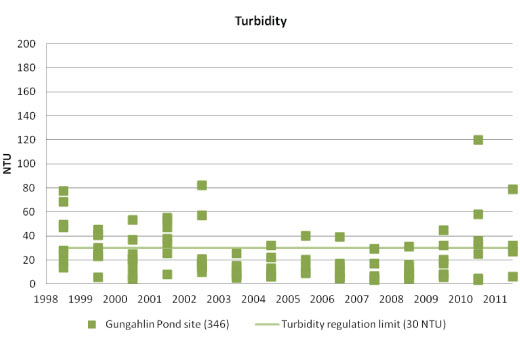
| Turbidity (NTU) | Not objectio-nable | Not objectio-nable | <10 - <30 | Modification of biological light regime; poor aesthetics, effects on plant and algal growth. | ||
| Suspended solids (mg/L) | <12.5 - <25 | Silt slugs; bank scouring; burial of riffles or aquatic vegetation; increased (long-term) turbidity. | ||||
| Chlorophyll ‘a’ (µg/L) | <10 | <10 | <10 | <2 - <10 | Poor aesthetics; scums; unpleasant smells; blooms outside of normal population fluctuation. | |
| Faecal coliforms (cfu/100 mL) | ≤ 150 | ≤ 1000 | ≤ 1000 | ≤ 1000 | Closure of recreational waters because of health risk from associated (hard to monitor) pathogens. | |
| Dissolved oxygen (mg/L) | >4 | Hot weather and low flows drive oxygen out of water, leading to biological stress, with fish kills being the worst outcome. | ||||
| Acidity (pH) | 6.5-8.5 | 6.5-8.5 | 6.5-9.2 | 4.5-9.0 | 6-9 | Altered pH could significantly change the biodiversity in waterways. Changes to biodynamics; may release toxic metals. |
| Total dissolved solids (mg/L) | <3000 | <500 | Water above 500 mg TDS/L (approximately equivalent to 800 µS/cm, in general) is unsuitable for irrigation, although some plants can tolerate higher concentrations. | |||
Source: ACT Water Reports
(Note:This table does not include the ACT Guidelines for Recreational Water Quality 2009, which include monitoring and standards for blue-green algae and enterococci and are discussed later.)
ACT lakes and ponds
As in previous reporting periods, water samples from ACT lakes and ponds continue to have high concentrations of chlorophyll 'a' especially in warmer months. Chlorophyll 'a' is an indicator for photosynthetic microorganisms present in aquatic ecosystems. Of these organisms, those of most concern are the potentially toxic blue-green algae, the cyanobacteria. See the Impact indicator in this paper for more information.
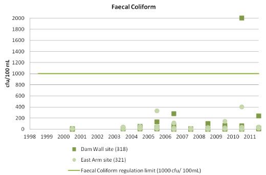
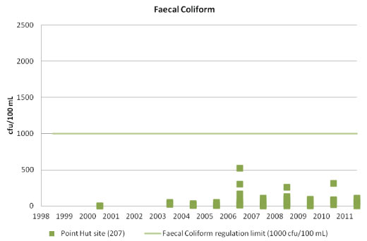
During the reporting period all 4 sampled lakes exceeded the ACT standards for phosphorus, dissolved oxygen, alkalinity, suspended solids and turbidity, one or more times. Faecal coliform bacteria were lowest in Point Hut Pond and Gungahlin Pond, where the measured value sometimes exceeded the standard for swimming (150 colony forming units (cfu) per 100 mL water) but remained below the limit for boating (1000 cfu/100 mL). Lake Tuggeranong reached the limit for boating in 2008-09, and Lake Ginninderra in 2010 had 1 record of 2000 cfu/100 mL. The high value possibly resulted from cleaning of a gross pollution trap, because most measurements recorded only 100-200 cfu/100 mL at the 2 sites sampled in Lake Ginninderra.
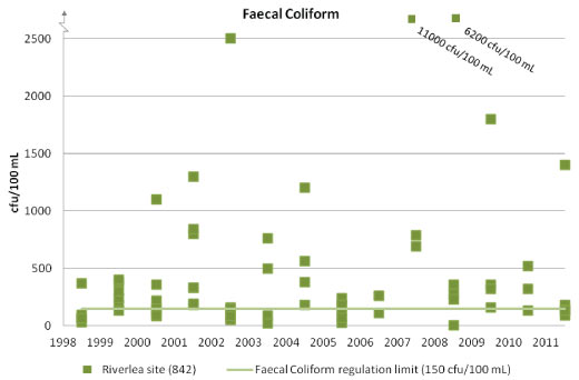
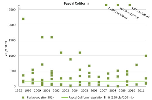
Overall, during the reporting period, the concentrations of faecal coliforms in ACT waterways were mostly within regulation limits, but there were exceedances in 2007 at 7 sites, and in 2009-10 at 5 sites. Recorded concentrations that far exceeded the limits included Paddy's River at Riverlea where faecal coliform concentration reached 4587 cfu/100 mL in 2007, compared to a limit of 150 cfu/100 mL. The exceedances in 2009-10 were attributed to the effects of significant rainfall.
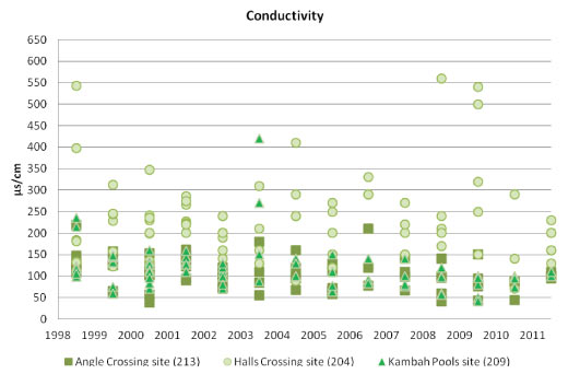
Salinity in ACT is measured as electrical conductivity (in microSiemens per centimetre, µS/cm, also called EC units). The salinity standard in Table 1 is set at 500 mg/L (milligrams total dissolved solids (TDS) per litre of water) for use in irrigation, a value that approximates to 800 EC units. During the reporting period, the salinities recorded in all waterbodies were less than 800 EC units. Maximum readings were around 550 EC units, recorded occasionally in the Murrumbidgee, Molonglo and Queanbeyan rivers during 2009 and 2010.
Long term data on water quality in ACT lakes, including data for this reporting period, are presented in Annex 1.
Lake Burley GriffinThe water in Lake Burley Griffin is monitored by the National Capital Authority, and data are not reported here. Monitoring is undertaken at the four specified swimming areas: Black Mountain Swimming Area, Weston Park (west) Swimming Area, Weston Park (east) Swimming Area, and Yarralumla Swimming Area.
A recent draft water quality assessment of the lake (Lawrence 2011) across all the monitored sites, has identified that in recent years, as compared to 1978, there have been:
- high levels of blue-green algal growth, frequently exceeding Health Guideline values;
- a shift towards greater blue-green algal dominance;
- a recent reduction in pH levels, as a result of increased organic material decomposition activity; and
- serious water quality degradation within the Beach embayments, as a result of shallowness, poor mixing, and trapping of open water wind-blown blue-green algal scum in these areas.
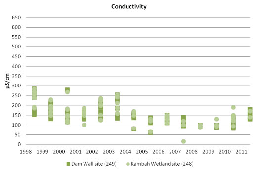
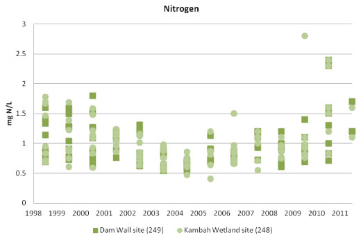
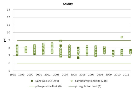
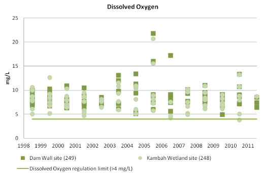
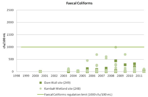
There are two water monitoring sites on Lake Tuggeranong, one located at the Kambah Wetland (Site 248), which is near the northern inflow to the Lake, and the other at the dam wall (Site 249). During the reporting period there have been many exceedances of the standard for phosphorus and for chlorophyll 'a', the latter possibly indicating the presence of blue-green algae. These happen especially during warmer months, and result in lake closures to reduce the risk to public health (for more information refer to the Impact indicator in this paper).
During the reporting period, measured turbidity concentrations, which are somewhat related to rainfall conditions, ranged from within the standard in 2007 to exceeding it several times in 2009 and 2010. There has been a decrease in electrical conductivity since 1998, which is likely to reflect a reduction in nearby construction work. Water quality (especially faecal coliform concentrations) in Lake Tuggeranong is affected by gross pollutant trap effectiveness.
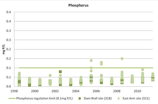
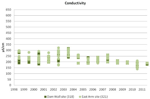
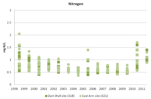
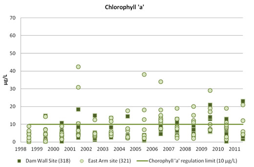
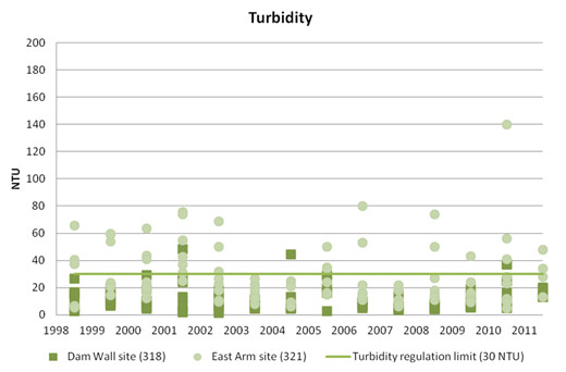
Lake GinniderraThere are two monitoring sites on Lake Ginninderra, one near the inflow of Ginninderra Creek in the east arm (Site 321) and the second near the dam wall (Site 318). During the reporting period, there were a number of exceedances of the chlorophyll 'a' standard, possibly indicating blue-green algae during warmer months. The readings caused lake closures for body-contact water sports.
Water quality monitoring for Lake Ginninderra also showed exceedances of suspended solid and turbidity concentrations, especially at the east arm site. This is likely to have resulted from local construction activity. Longer term trends show that water quality in the lake is generally good.
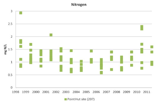
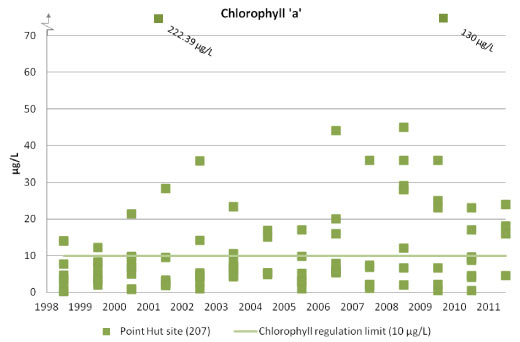
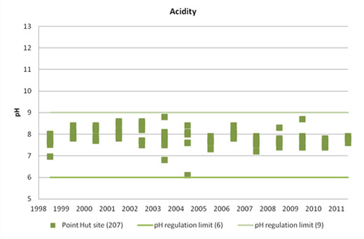
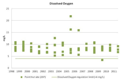
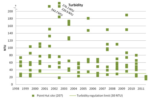
Point Hut PondThere is one monitoring site on Point Hut Pond (Site 207). Exceedances of chlorophyll 'a', suspended solids and turbidity standards were common during the reporting period. The standard for phosphorus was also exceeded several times in 2007, and once or twice in 2008, 2009 and 2010. Faecal coliform readings were generally within the standard during the reporting period. However, Point Hut Pond water quality has historically been poor; its catchment is primarily urban (DECCEW 2010).
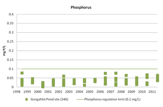
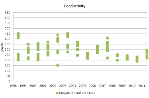
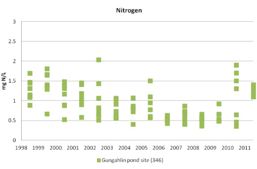
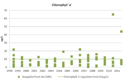
Gungahlin PondAt the one monitoring site on Gungahlin Pond (Site 346), water quality generally remained within regulation limits. As with the other lakes and ponds, exceedances were experienced in chlorophyll 'a' during the reporting period. The limits for turbidity and suspended solids were exceeded several times, with a high reading in February 2010 likely to have resulted from the storms in January 2010. Longer term trends indicate improved water quality in the Pond, particularly in dissolved oxygen, conductivity and faecal coliform concentrations.
Lakes and ponds generally show improvement in water quality between the inflow points and the dam walls, indicating the lakes are fulfilling the important role of improving water quality before it discharges into our river systems.
ACT rivers and creeks
The drought and extreme rainfall during the reporting period affected the water quality of rivers and creeks in the ACT and as a result surface water quality in the rivers was very varied. Sites affected by the 2003 bushfire appear to have recovered from the impacts and accommodated the ongoing periods of low flow, albeit at lower quality. Sites in urban and peri-urban areas appear generally affected by human actions such as altered flow regimes, nutrient enrichment, weed infestation and increased pollutants (DECCEW 2009, DECCEW 2010).
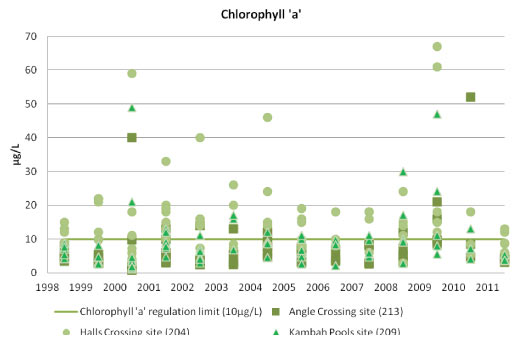
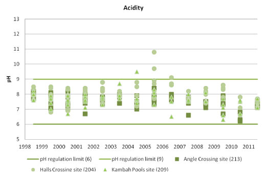
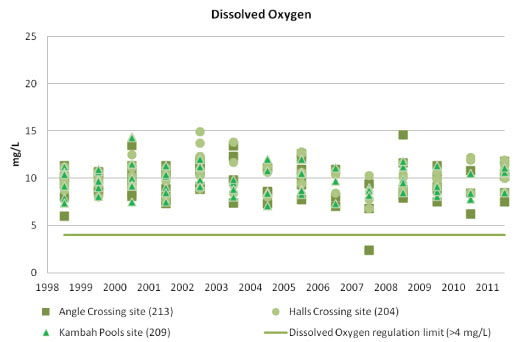
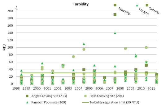
Murrumbidgee RiverThe Murrumbidgee River is the main river in the ACT and receives most of the material transported throughout ACT waterways (DECCEW 2010). There are three monitoring sites on the Murrumbidgee River: at Angle Crossing (Site 213) as the river enters the ACT, at Kambah Pools (Site 209), and Halls Crossing (Site 204) in NSW just downstream of the ACT.
The Halls Crossing site (204) is more alkaline and has higher conductivity and nitrogen levels than the other sites, which are upstream of urban areas (DECCEW 2009). Exceedances of chlorophyll 'a' were recorded at all sites during the reporting period, indicating that the river has become eutrophic and likely to be heavily contaminated by blue-green algae. Exceedances of the limits for faecal coliforms and turbidity also occurred at all sites in 2007-08 and 2009 and 2010, most likely due to low flows in 2007-08 and heavy rains in February 2010 (DECCEW 2008, 2010). Longer term trends indicate a rise in suspended solids and turbidity in the year following the 2003 fires and spikes in these indicators following high rainfall events since then. This indicates that the Murrumbidgee catchment remains fragile following the fire, and that storm events have a significant impact on the quality of the water (DECCEW2009).
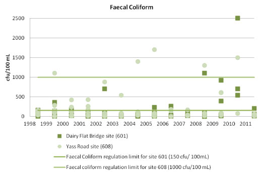
Molonglo RiverThere are two monitoring sites on the Molonglo River: Dairy Flat Bridge (Site 601), near the water-ski area, and Yass Road Bridge (Site 608) downstream of the Molonglo Gorge. The river runs through a highly urbanised catchment and is subject to pressures from urban and industrial sites including Queanbeyan and other NSW towns such as Captains Flat. It also receives the discharge from the Queanbeyan sewage treatment plant near Oaks Estate in the ACT.
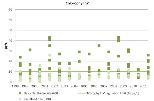
The Dairy Flat Bridge site (601) continued to show elevated levels of chlorophyll 'a' throughout the reporting period. The readings were identified as due to the toxic blue-green alga Microcystis aeruginosa and they resulted in closures of the site to recreational water users. Both nitrogen and phosphorus concentrations at the Dairy Flat Bridge site remain high, and management of these related parameters is encouraged.
Dissolved oxygen concentrations at the Yass Road Bridge site (608) increased during the period, though the readings were below the regulation limit. Long-term trends in dissolved oxygen continue to show fluctuations, which appear to be correlated with the mean annual flow in the river (DECCEW 2009).
There were exceedances in both suspended solids and turbidity during 2010 at both sites following high rainfall events (DECCEW 2010).
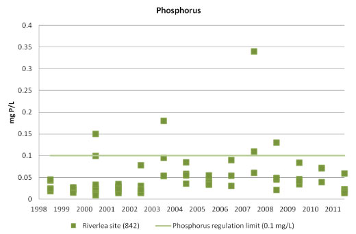
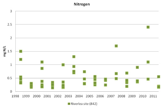
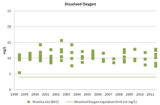
Paddy's RiverWater quality samples for Paddy's River (Site 842) showed the water quality was generally good over the reporting period. The catchment has a mix of conservation, agricultural and forestry land uses, and large parts of the catchment were affected by the 2003 bushfire.
High electrical conductivity readings recorded in 2009 are likely to result from low flows during this time. In December 2009 there was no water flow recorded in the river below the Riverlea homestead (DECCEW 2009, 2010).
Faecal coliform concentrations over the period which consistently exceeded the limit for swimming were likely to result from rural activities and slow post-fire stabilisation of catchment areas (DECCEW 2010). With a popular picnic spot at Murray's Corner, management of faecal organism concentrations is important.
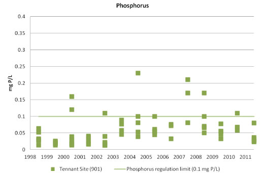
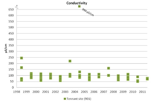
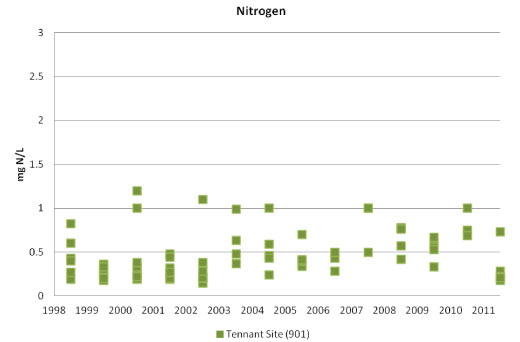
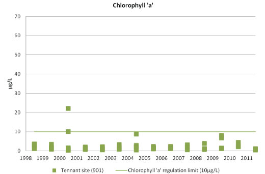
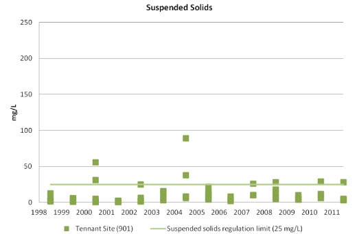
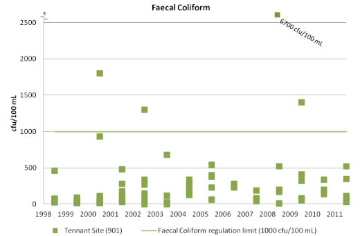
Gudgenby RiverWater quality samples for Gudgenby River are taken at Tennant (Site 901). The Gudgenby River catchment is dominated by native species and limited agriculture. Large parts of the catchment were affected by the 2003 bushfire. During the reporting period, water quality in Gudgenby River was generally good. There was a significant peak in faecal coliform concentration in 2008 and fluctuations over the reporting period, which may be explained by changing stock densities in the rural catchment. Faecal coliform bacteria of livestock origin can affect human health, and efforts to reduce these concentrations are encouraged.
Turbidity concentrations also fluctuated throughout the period, with several exceedances likely to have resulted from rain events. Phosphorus concentrations also exceeded the limit on several occasions during the reporting period.
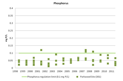
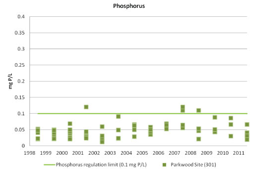
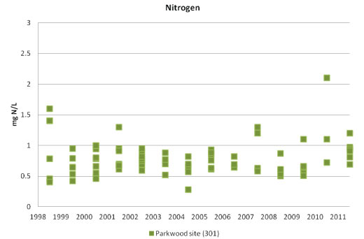
Ginninderra CreekWater quality samples for Ginniderra Creek are taken at Parkwood (Site 301). The creek runs through a highly urbanised catchment, including Gungahlin where significant construction has been occurring in recent years. Very high concentrations of faecal coliforms were recorded during the reporting period and may be associated with low water levels and flows, urban run-off or sewage contamination. Elevated turbidity and suspended solids concentrations occurred in 2010 as a result of storms.
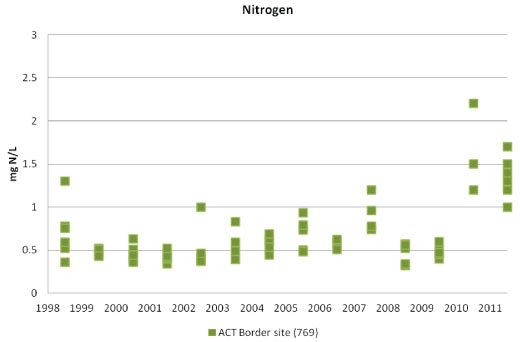
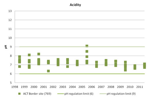
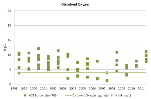
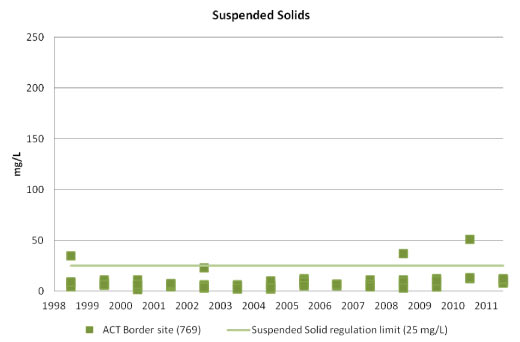
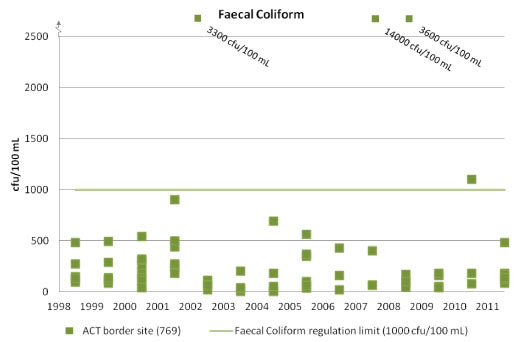
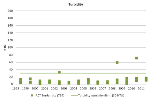
Queanbeyan RiverWater quality in the Queanbeyan River is sampled at the ACT border (Site 769), before the river reaches the Molonglo River. (Quality of potable water supplied from upstream parts of the Queanbeyan river via Googong Reservoir is reported in the Water supply indicator cluster.) The catchment includes the city of Queanbeyan. Water quality over the reporting period was generally good. However, concentrations of dissolved oxygen dropped below regulation limits in 2007 and 2009. This was associated with low flow in the river. Quality over the period is reflective of longer term trends which show fluctuations in dissolved oxygen correlated with the mean annual flow in the river (DECCEW 2009).
Pressure indicators [top ]
Discharge to waters
Discharges to waters from known point sources can place significant pressures on water quality. In the ACT the two main point sources for discharge are the Lower Molonglo Water Quality Control Centre (LMWQCC), and the Queanbeyan Sewage Treatment Plant. The LMWQCC treats most of ACT's wastewater and sewage and discharges it to the Molonglo River, approximately 1.4 km upstream of the confluence of the Molonglo and Murrumbidgee rivers.
The LMWQCC is the single largest point source of pollutants within the ACT. The LMWQCC treated 26,769 ML of sewage in 2009-10, and 32,336 ML in 2010-11 (ActewAGL 2011). Because of the environmentally sensitive nature of the receiving waters the LMWQCC has implemented a comprehensive environmental monitoring program, which includes biological monitoring of the receiving waterways (DECCEW 2010). The LMWQCC and its discharge are regulated through an Authorisation issued by the EPA. During the reporting period, data were reported to the EPA, and the EPA has not recorded any breaches to the limits and conditions of the Authorisation.
The Queanbeyan Sewage Treatment Plant (QSTP) discharges treated effluent into the Molonglo River just inside the ACT. During the reporting period, effluent discharge increased from an average of 8.71 ML/day in 2007 to 9.22 ML/day in 2010. The EPA notes the Queanbeyan City Council (QCC) was generally compliant with its Authorisation for the plant during the reporting period with the only non-compliances relating to reporting times or data formatting. The discharge requirements imposed through their Authorisation are consistent with those that apply to the LMWQCC. However, there was an incident at the QSTP during December 2010 which potentially posed environmental harm to downstream waters such as Lake Burley Griffin. At that time, during localised flooding, a breach of a wall at a secondary treatment maturation pond released partially treated sewage into the Molonglo River. The EPA is currently investigating this incident. Both the EPA and the QCC recognise that the ageing plant is near the limit of its capacity to treat the effluent generated by the growing city of Queanbeyan. Unless the plant is upgraded it is likely that non-compliances with the Authorisation will become more frequent.
A recent draft water quality assessment of Lake Burley Griffin indicated that there has been a significant reduction in total phosphorus and biochemical oxygen demand (BOD) in the treated water discharged from the QSTP over the past 30 years. This is a result of major upgrades to the plant (Lawrence 2011).
Nutrients in stormwater may be the largest factor leading to poor water quality and excessive concentrations of blue-green algae in Lake Burley Griffin (Lawrence 2011). Perhaps one of the less notable but extremely significant modifiers of water quality is the contribution that diffuse sources make through the Canberra stormwater system.
Land use can also have a significant impact on the quality of water in rivers, lakes and wetlands as well as in groundwater. For example, land use can affect the total amounts of suspended solids and nutrients (phosphorus and nitrogen) in the waterways. As outlined in the Land health indicator cluster, over 50% of the ACT is managed as conservation reserves, which are characterised by less runoff and erosion than urban and rural land uses, and therefore contribute smaller amounts of suspended solids and nutrients to waterways. When waters contain too high concentrations of nutrients relative to their capacity to assimilate them, the excess nutrients can promote growth of cells such as algae including blue-green algal blooms (see Impact indicator below).
Impact indicators [top ]
Water quality and human health impacts
Pathogens
Water quality standards are set with the aim of protecting the community and ecosystems from adverse health impacts. Water bodies generally contain a mixture of pathogenic and non-pathogenic organisms which can cause infection or disease. These pathogens may derive from a number of sources including sewage effluent overflows, as well as domestic, rural and native animals (ACT Health 2009). Human exposure to pathogens in water can occur through swallowing water or by water coming into contact with ears, eyes, nasal passages, mucous membranes or cuts in the skin (e.g. when swimming, diving, waterskiing, windsurfing, whitewater canoeing).
A pathogen's potential health impacts on a person depend on the specific pathogen, the form in which it is encountered, the conditions of exposure, and the person's susceptibility and immune status (ACT Health 2009).
The most common health impacts are enteric illnesses, such as self-limiting gastroenteritis, which may often be of short duration and may not be formally recorded in disease surveillance systems. Other adverse health effects such as respiratory illness, ear infections and skin and eye problems are also associated with recreational activities in contaminated water (ACT Health 2009).
Testing conducted at various sites across the ACT checks surface waters for potentially harmful bacteria. High concentrations of bacteria in the water could be harmful to human health, although they are not necessarily a problem for organisms in aquatic ecosystems that can feed on the bacteria. One method used to quantify the water quality and its potential impacts on human health is to measure the faecal coliforms in the water bodies. The World Health Organization advocates the use of intestinal enterococci as the single preferred indicator of faecal contamination. The presence of faecal coliforms or enterococci in a water sample is an indication that human or animal faeces may have contaminated the water. The standard (maximum advised) for recreational swimming is 150 colony forming units (cfu) of faecal coliforms per 100 mL of water, or 200 cfu of enterococci per 100 mL of water. For boating and other secondary contact the regulation limit or standard is 1000 cfu/100 mL. The EPA has set the faecal coliform standard at 1000 cfu/100 mL of water at all but five monitoring sites. The faecal coliform standard is set at 150 cfu/100 mL of water at Lake Tuggeranong at Dam (Site 249), Lake Ginninderra at Dam (Site 318) and at all 3 sites on the Murrumbidgee River (Halls Crossing - Site 204 , 209, Kambah Pool - Site and at Angle Crossing - Site 213). The limits are lower at these sites because primary contact with water (usually recreational swimming) is most likely near these sites.
As reported above (in Condition indicators) during the reporting period, the levels of faecal coliforms in ACT waterways occasionally exceeded regulation limits for swimming or boating. Bacterial levels in surface waters are generally higher following rainfall events, as a result of runoff from the surrounding urban and rural catchments. For example, the runoff collects pollutants from urban stormwater pipes and rural grazing land.
It should be noted that high concentrations of faecal coliforms do not necessarily indicate that human sewage is present in waterways; rather it is more likely a result of organic matter and rural animal waste attached to suspended solids. Faecal coliforms of livestock origin are frequent causes of adverse human health outbreaks.
A number of the ACT's rural rivers were closed to primary contact because of human health concerns as a result of the significant rainfall in late 2010.
Blue-green (cyanobacterial) algal blooms
Blue-green algae are common and naturally occurring organisms that can affect the recreational use of ACT waterways because of the public health risk they pose when present in high concentrations. Blue-green algal blooms are of particular concern for human health because of the variety of toxins which may be produced (Falconer 2005). Blooms generally occur where waters are warm and have high concentrations of nutrients, often in summer.
Blue-green algal cells in low numbers in a water body are not necessarily a risk. However, when these organisms multiply they form scums on the water surface which drift downwind into swimming areas and pose an increased health risk. In the ACT, the main toxic blue-green algae of concern are free floating forms such as Microcystis and Anabaena species, and also Tychonema species that live on the beds of rivers or lakes. These organisms present a particular health risk to humans and animals if taken in by mouth or by inhalation. Skin contact can cause allergic reactions.
Monitoring of ACT rivers and lakes includes counts of blue-green algae cells as well as measurement of chlorophyll 'a' concentrations to estimate the total quantity of algae (cyanobacteria and green algae) present. Chlorophyll 'a' is an indicator of the extent to which aquatic ecosystems have been affected by nutrient inputs. All rivers, urban lakes and ponds in the ACT are expected to contain no more than the standard, 10 µg/L (10 micrograms of chlorophyll 'a' per litre of water). For more information see Rivers, lakes and wetlands health indicator cluster.
Blue-green algal cell counts are carried out when samples are taken in accordance with the ACT Guidelines for Recreational Water Quality; that is, when a high value for chlorophyll 'a' has been measured at a particular location, or when high concentrations of blue-green algae have been visually identified. Blue-green algal monitoring can also be carried out by visual inspection, because clumps of the organisms can be seen in lake water when present.
Over the reporting period, ACT lakes contained elevated concentrations of chlorophyll 'a' and sporadic high or extremely high concentrations of blue-green algae. These elevated concentrations generally occurred between spring and autumn of each year, with peaks in February or March.
In December 2009, the ACT introduced new ACT Guidelines for Recreational Water Quality. Prior to the new guidelines, if a sample triggered a high-level alert (=50,000 blue-green algae cells/mL) the lake from which the sample was taken was closed to primary and secondary contact. Under the new guidelines a lake is only closed to primary contact (e.g. swimming) at a high- or extreme-level alert. At extreme levels (>125,000 blue-green algae cells/mL, or scums are consistently present) the public must also be advised that contact with water poses an increased level of risk for secondary contact users (e.g. boating) (ACT Health 2009).
Over the reporting period, there were a number of outbreaks of blue-green algae in ACT lakes and waterways. Lake Tuggeranong had a high- to extreme-level alert every summer from 2007 to 2011, while Lake Ginninderra and the Molonglo Reach Water Ski Area were affected less frequently by blue-green algal blooms. In most cases during the reporting period, the high- to extreme-level alerts in the ACT occurred in the summer months. This is generally when more people use these waterways. Table 2 gives a summary of the blue-green algal outbreaks and monitoring.
Table 2. Alert dates for algal blooms in ACT lakes
| Lake | Date | Alert |
|---|---|---|
| Lake Tuggeranong |
6 weeks, 2 days from 27 November 2007 3 weeks, 2 days from 12 March 2008 2 days from 3 February 2009 10 weeks, 2 days from 5 February 2009 13 weeks, 2 days from 18 May 2009 11 weeks from 28 January 2010 6 weeks from 15 April 2010 4 weeks 1 day from 10 February 3 weeks from 11 March 2011 2 weeks from 1 April 2011 |
High High Medium High Medium Extreme Medium High Extreme Lake Closed |
| Lake Ginninderra |
1 week 1 day from 3 February 2009 13 weeks 4 days from 11 February 2009 13 weeks 2 days from 18 May 2009 7 weeks from 22 April 2010 |
Medium High Medium Medium |
| Molonglo Ski Area |
1 week 1 day from 3 February 2009 18 weeks 1 day from 11 February 2009 8 weeks, 6 days from 18 2009 1 week from 14 January 2010 1 weeks from 21 January 2010 4 weeks from 28 January 2010 5 weeks from 8 April 2010 |
Medium High Medium Medium Extreme High Medium |
Source: DECCEW
The most recent 2010-11 recreational season closures for Lake Burley Griffin were (NCA 2011):
- “closure to all recreational users (excluding commercial ferry boat operators) for a period of less than two weeks of the six month recreational season due to high levels of faecal pollution, in part due to a Queanbeyan Sewage Treatment Plant spill in early December 2010”.
- “the entire lake closed to primary contact users only for a total of three weeks throughout the six month season, although there have been scattered closures to primary contact users across the lake sites at various points in time”.
- “the lake was open to all users across the majority of sites for a period of 20 weeks throughout the season and open across all sites for 16 of these weeks”.
Results from samples taken on 28 February 2011 reflected a spike in bacteria at Black Mountain Beach, Weston Park East and Weston Park West. Further investigation revealed that this spike was the result of ACT Roads cleaning out the Gross Pollutant Trap in Sullivans Creek on Thursday, 24 February 2011. Levels returned to normal within two weeks following this event (NCA 2011).
Response indicators [top ]
Recreational water quality
The ACT Guidelines for Recreational Water Quality, introduced in December 2009, provide a current framework for the management of recreational water sites within the ACT (ACT Health 2009). This document introduced new guidelines for managing recreational water quality, including the risks from blue-green algae and microbial pathogens.
Under the Lakes Ordinance 1976, the National Capital Authority (NCA) is responsible for the management of Lake Burley Griffin and undertakes regular water quality testing for blue-green algae and bacteria. The NCA takes weekly samples and tests water across 7 sites between mid-October and mid-April each year. Based on the ACT Guidelines for Recreational Water Quality (2010), these results are assessed and a decision is reached as to the status of each site around the lake for that week (NCA 2011).
In addition to weekly sampling throughout the recreational season, a routine sampling program is conducted across 5 mid-stream sites within the Lake. Water quality conditions are assessed and reported on a monthly basis (for 8 months of the year) to determine the overall water quality at these sites. The results from these reports are analysed annually and compared with historical data and the benchmark values of the Lake Burley Griffin Water Quality Management Plan.
During the reporting period the Office of the Commissioner for Sustainability and the Environment was requested to undertake an investigation into the state of the watercourses and catchments for Lake Burley Griffin. This is expected to be completed in 2012 and will provide an assessment of the origins of the poor water quality in the lake and may impact on future water quality management.
Effluent water treatment
Wastewater in the ACT is treated at the Lower Molonglo Water Quality Control Centre (LMWQCC), to a tertiary level. This includes screening to remove solids, biological treatment by activated sludge to remove organic material, and tertiary filtering to remove suspended solids and produce a clear effluent. The effluent is then dosed with chlorine to remove any remaining microbiological pathogens, and discharged to the Molonglo River. On average, LMWQCC treats 80-100 ML of wastewater each day. The sludge and screenings from the wastewater is converted to Agri-Ash, which can be used as a soil conditioner for agricultural purposes. To minimise waste from the wastewater treatment (apart from carbon dioxide), the LMWQCC produces approximately 16 tonnes of Agri-Ash a day.
Effluent is also treated at the Queanbeyan Sewage Treatment Plant and discharged into the Molonglo River. During the reporting period, effluent discharge increased from an average of 8.71 ML/day in 2007 to 9.22 ML/day in 2010.
Water reuse and stormwater harvesting
Reusing water is an alternative to using potable water, and can reduce the demand for ACT's water supplies and the associated withholding of water from aquatic environments (see Water supply indicator for further details). In the ACT, water reuse provides water for irrigation of playing fields, and industrial and commercial uses.
The Australian Guidelines for Water Recycling: Managing Health and Environmental Risks (Phase 1) outline a national framework for water recycling management, including appropriate qualities of water for different uses. However, it is the responsibility of each state and territory government to ensure that appropriate health and environmental standards are being met by water reuse initiatives.
Currently there is no legislation in the ACT primarily focused on the safe management and use of greywater. Rather, the installation and use of greywater systems is guided by various pre-existing acts and regulations:
- ACT Public Health Act 1997, Public Health Regulations 2000 - the Act protects the public by preventing the creation of unsanitary conditions (conditions that may risk, damage or offend public health) and gives ACT Health the power to rectify the condition and penalise offenders.
- Water and Sewerage Act 2000, Water and Sewerage Regulations 2001 (under Construction Occupations (Licensing) Act 2004 (COLA), AS/NZS 3500 - the regulation requires all plumbing work to be undertaken by licensed plumbers. While greywater systems do not need to be formally registered on installation, the plumber is required to notify ACTPLA prior to beginning work.
- Environment Protection Act 1997 - this Act protects the environment against activities that cause environmental harm. Greywater systems are thus prohibited from contaminating environmental flows, groundwater and surrounding biodiversity. Greywater cannot be the source of offensive odours or other forms of pollution.
Stormwater is also used as a water resource throughout the community. Over the reporting period, the ACT Government implemented the Canberra Integrated Urban Waterways project, to improve water quality within Sullivans Creek (DECCEW 2011). The project focuses on integrating stormwater and urban waterways, by investigating opportunities such as stormwater harvesting and injection to groundwater storages by managed aquifer recharge. The project will develop a non-potable water reticulation system, which includes direct injection of stormwater to underground aquifers for storage and recovery.
Three pilot stormwater harvesting and injection projects have been implemented as part of the Urban Waterways project:
- Inner North Stormwater Reticulation Network (Flemington Road Ponds and Dickson and Lyneham Ponds);
- Weston Creek Stormwater Reticulation Network (North Weston Pond); and
- Tuggeranong Stormwater Reticulation Network (Lake Tuggeranong and Isabella Pond).
Also during the reporting period a number of wetlands were constructed in the urban area with the aim of providing a range of benefits including water quality improvements (see Rivers, lakes and wetlands health indicator cluster for further information). It is too early to assess the effectiveness of these wetlands in relation to water quality.
Gross pollutant traps are intended to capture coarse pollutants from stormwater before it drains into receiving waters. As identified in the last reporting period, there are no data available on the overall adequacy of the urban gross pollutant traps or their maintenance. Such information is important in assessing the effectiveness of these structures in controlling pollution in surface water, and should be collected and monitored on a regular basis.
Glossary [top ]
Electrical conductivity: a routinely used measure of salinity in water. While an appropriate concentration of salts is vital for aquatic plants and animals, salinity that is beyond the normal range for any species of organism will cause stress or even death to that organism. Salinity also affects the availability of nutrients to plant roots.
Eutrophic: waters containing large quantities of dead plant material that uses up dissolved oxygen as it decays, and adds nutrients in the process, which can lead to algal blooms
Greywater: untreated domestic or industrial wastewater
Turbidity: a measure of water clarity or the cloudiness of water resulting from the presence of suspended material such as silt and clay; turbidity is recorded in NTU (nephelometric turbidity units), based on how much light is scattered by the suspended particles
References [top ]
ACT Health 2009. ACT Guidelines for Recreational Water Quality, ACT Health, Canberra. http://www.health.act.gov.au/c/health?a=sendfile&ft=p&fid=1281404492&sid= (accessed 31/8/11)
ANZECC & ARMCANZ 2000. Australian and New Zealand Guidelines for Fresh and Marine Water Quality. National Water Quality Management Strategy paper no.4. Australian Government Department of Sustainability, Environment, Water, Population and Communities, Canberra. http://www.environment.gov.au/water/policy-programs/nwqms/#guidelines (accessed 27/11/11)
DECCEW 2008. ACT Water Report 2007-08. Environment Protection and Heritage, Territory and Municipal Services, Department of the Environment, Climate Change, Energy and Water. Canberra http://www.environment.act.gov.au/__data/assets/pdf_file/0005/152159/Annual_Report_2007-2008_Pdf.pdf (accessed 25/11/11)
DECCEW 2009. ACT Water Report 2008-09. Department of the Environment, Climate Change, Energy and Water, Canberra http://www.environment.act.gov.au/__data/assets/pdf_file/0003/175206/DECCEW_Water_Report_FINAL_FINAL.pdf (accessed 25/11/11)
DECCEW 2010. ACT Water Report 2009-10. Department of the Environment, Climate Change, Energy and Water, Canberra. http://www.environment.act.gov.au/__data/assets/pdf_file/0008/227978/DECCEW_Water_Report_WEB.pdf (accessed 25/11/11)
DECCEW 2011. Constructed Wetlands. Department of the Environment, Climate Change, Energy and Water, Canberra. http://www.environment.act.gov.au/water/constructed_wetlands (accessed 9/6/11)
Falconer, I.R. 2005. Cyanobacterial Toxins of Drinking Water Supplies. CRC Press, New York
Lawrence, I. 2011. Investigation into the state of water courses and catchments for Lake Burley Griffin: Water Quality Assessment Draft Report. Office of the Commissioner of Sustainability and the Environment. Canberra
MDFRC 2005. Wetland salinity: predicting the ecological consequences. Murray-Darling Freshwater Research Centre, Wodonga, Victoria. http://www.mdfrc.org.au/publications/images/Salinity_Factsheet_3_What_Is_Salinity1.pdf (accessed 12/9/11)
NCA 2011. Lake Burley Griffin Water Quality Management Fact Sheet. Australian Government National Capital Authority, Canberra. http://www.nationalcapital.gov.au/haveyoursay/attachments/article/143/LBG_Water_Quality_Management_Factsheet.pdf (accessed 25/11/11)
NHMRC 2004. Australian Drinking Water Guidelines. Australian Government National Health and Medical Research Council, Canberra. http://www.nhmrc.gov.au/publications/synopses/eh19syn.htm (accessed 31/5/11)
VDPI 1999. Measuring the salinity of water. http://www.dpi.vic.gov.au/agriculture/farming-management/soil-water/salinity/measuring-the-salinity-of-water (accessed 12/9/11)
Other data sources
In addition to these published reports, data for this paper were also sourced from:
- ACT Department of the Environment, Climate Change, Energy and Water (DECCEW) - now Environment,Sustainability and Development Directorate (ESDD)
- ActewAGL 2011. LMWQCC monitoring data. ActewAGL. Canberra
Annex 1 [top ]
ACT Lakes Water Quality
Lake Tuggeranong water quality indicators


Lake Ginninderra water quality indicators


Point Hut Pond water quality indicators


Gungahlin Pond water quality indicators


ACT Rivers and Creeks Water Quality
Murrumbidgee River water quality indicators


Note: the scale of the mg N/L data range differs from other sites due to higher reading values


Molonglo River water quality indicators
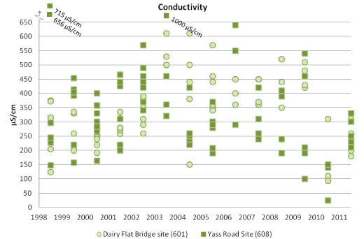
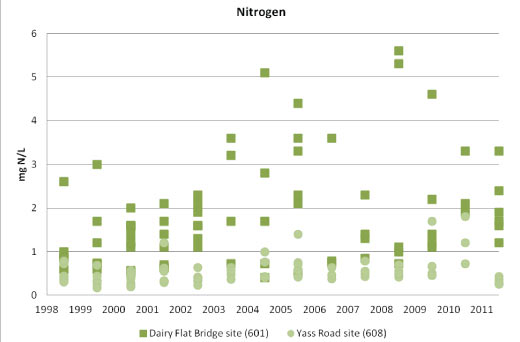
Note: the scale of the mg N/L data range differs from other sites due to higher reading values


Paddy?s River water quality indicators


Gudgenby River water quality indicators


Ginninderra Creek water quality indicators


Queanbeyan River water quality indicators


Share this page: