


ACT State of the Environment Report 2011
Accurate, timely & accessible information for the community regarding the condition of the environment, underlying pressures, and sustainability trends.
THEME: Biodiversity
Indicator cluster: Ecological communities
Download: Indicator cluster: Ecological communities.pdf
The indicators for this cluster are:
- Vegetation communities (C) - extent and distribution of vegetation communities;
- Vegetation condition (C) - the quality and condition of vegetation including remnant areas and connectivity;
- Protected areas (C) - area and distribution of protected areas, and new areas;
- Vegetation clearance (P) - area, distribution, fragmentation of connectivity and loss of soil;
- Conservation management (R) - effectiveness of conservation management responses including biodiversity offsets and connectivity restoration; and
- Protected area management (R) - effectiveness of protected area management.
Condition indicators (C) present data that tell us the state of the environment at any particular time.
Pressure indicators (P) present data about the main human activities that could potentially adversely affect the condition of the environment.
Impact indicators (I) present data on the effect that environmental changes have on environmental or human health.
Response indicators (R) present data about the main things we are doing to alleviate pressures, or to improve the condition of the environment.
Summary [top  ]
]
Thirty vegetation communities have been recorded within the ACT, of which Yellow Box-Red Gum Grassy Woodland, Alpine Fens and Bogs, and Natural Temperate Grassland are listed as endangered ecological communities under both the ACT Nature Conservation Act 1980 and the Commonwealth Environment Protection and Biodiversity Conservation Act 1999. Approximately 40% of the remaining area of these endangered ecological communities is now protected in nature reserves. A major threat to endangered ecological communities is urban development - a threat exacerbated by the strong economic position of the ACT because of the prevalence of large houses on separate blocks of land within the ACT and in neighbouring NSW.
Information is not available that would allow an accurate assessment of changes to the extent and condition of native vegetation in the ACT during the reporting period, but the ACT Woodland Assessment Project 2011 has determined that approximately 828 ha of lowland woodlands was cleared for urban development between 2003 and 2010. Natural temperate grasslands were mapped in the ACT in 2006. Since then 147 ha has been cleared, of which 145 ha has been on Commonwealth land. A mapping project is underway that will provide information on the extent of native vegetation, its condition and the connectivity of protected areas. No wildfires were identified during the reporting period that would contribute to vegetation modification. Since 2007, 3 new nature reserves have been gazetted and a further 2 are proposed. An ACT Biodiversity Offsets Policy is currently being developed as part of the review of the Nature Conservation Act.
Introduction [top ]
An ecological community is a naturally occurring assemblage of plant and animal species occupying the same geographical area. The species are functionally linked through direct or indirect influences on each other.
Reporting on the state of ecological communities in the ACT is important because they are an indicator of the condition of the natural environment, demonstrating the extent to which human activities have had an impact, and how well these impacts and other pressures have been moderated through management. Knowledge of the condition of ecological communities is also important for planning future development in the region and for identifying management strategies that could assist in improving the condition and extent of the native vegetation of the ACT.
Condition indicators [top ]
Vegetation types
In the ACT, 30 vegetation types are recognised. Of the 19 types mapped in Figure 1, forest occupies the largest area. Changes to the extent and distribution of these vegetation types since 2007 have not been recorded, but research is now classifying and mapping their current distribution.
Figure 1. Vegetation types in the ACT
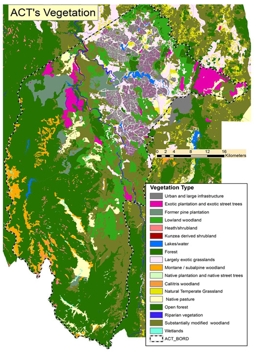
Source: TAMS
Under the ACT Nature Conservation Act 1980, 2 of the 30 vegetation types are listed as endangered. These are:
- Yellow Box-Red Gum Grassy Woodland; and
- Natural Temperate Grassland.
Yellow Box/Red Gum Grassy Woodland
Yellow Box-Red Gum Grassy Woodland is an endangered ecological community primarily because of previous land-clearing activities. It is of high conservation value, typically having a species-rich understorey that includes native grasses, forbs and shrubs. This ecological community supports suitable habitat for a number of threatened flora and fauna, such as the Button Wrinklewort (Rutidosis leptorrhyncoides) and the Hooded Robin (Melanodryas cucullata).
Yellow Box-Red Gum Woodland is the primary focus of Action Plan No. 27: ACT Lowland Woodland Conservation Strategy 2004 (TAMS 2004). The Action Plan outlines conservation and protection proposals for this ecological community, to minimise the effect of threatening processes.
Recent mapping has estimated that there are now approximately 12,034 ha of Yellow Box-Red Gum Grassy Woodland in the ACT - less than half of its original extent (Michael Mulvaney pers. comm. 2011). Urban development and agriculture in the Territory have destroyed or severely modified much of this ecological community. Currently 6160 ha of Yellow Box-Red Gum Grassy Woodland are protected in nature reserves (PCL), leaving more than 5500 ha unprotected. These areas are under continued threat from urban development expansion in particular, as well as from other land uses.
During the reporting period 322 ha of Yellow Box-Red Gum Grassy Woodland were added to the existing nature reserves while an additional 201 hectares are currently being managed for conservation in Kinlyside Reserve, near Hall in north-western ACT. Declaration of Kinlyside Reserve as a Nature Reserve is being considered.
Significant examples of Yellow Box-Red Gum Grassy Woodland previously protected in the ACT are in nature reserves at, for instance, Mulligans Flat, Goorooyarroo, Mount Ainslie, Mount Majura, Mugga Mugga, and Callum Brae.
Currently all areas of Yellow Box-Red Gum Woodland are being assessed for their potential for listing on the ACT Heritage Register as Natural Heritage Places. A draft nomination has been completed and forwarded to the ACT Heritage Council for consideration. The benefit of listing as a Natural Heritage Place is that such a listing would provide an additional layer of protection against threats, particularly urban development.
Natural Temperate Grassland
Natural Temperate Grassland is an ecological community under considerable threat. It is estimated that there were 20,000 ha of Natural Temperate Grassland in the ACT area prior to European settlement. Approximately 5% (1000 ha) of this grassland currently remains, in remnants recorded at 39 locations. Most of them are very small: only 4 sites are larger than 100 ha. Nationally, less than 1% of the original (pre 1788) community remains. In the ACT, 147 ha of Natural Temperate Grassland have been cleared since 2006; 145 ha of this was at the Canberra airport on Commonwealth land under Commonwealth approval processes (PCL).
The Natural Temperate Grassland ecological community is included in Action Plan No. 28: ACT Lowland Native Grassland Conservation Strategy (TAMS 2005). A draft implementation review of Action Plan No. 28 was prepared in June 2008. High priorities for management are the major threats to Natural Temperate Grasslands: urban development, herbivore grazing including by kangaroos, and weed invasions. Among protection priorities is a requirement that all land development proposals take into account protection of conservation areas, and minimise impacts to other areas of Natural Temperate Grasslands.
Since 2008, all sites of Natural Temperate Grasslands have been nominated as Natural Heritage Items, and are being assessed by the ACT Heritage Council. Nomination for these sites is yet to be resolved (see Heritage indicator cluster for information on the heritage assessment backlog). During the reporting period, the Report on ACT Lowland Native Grassland Investigation by the Office of the Commissioner for Sustainability and the Environment considered 49 lowland native grassland sites in the ACT, on both national and Territory land (OCSE 2009). The investigation found that the ACT is in a strong position to be able to advance the protection of lowland native grassland, in particular Natural Temperate Grassland communities and the species these grasslands support (OCSE 2009). However, management will be challenged by the fragmentation of the grassland sites and their proximity to urban areas (OCSE 2009).
Vegetation of Conservation Concern
In the 2007-08 ACT State of the Environment Report, 5 vegetation communities were assessed as likely to have less than 30% of their former distribution remaining, and therefore to be of concern:
- Snow Gum-Candlebark Tableland Woodland;
- River She-oak Tableland Riparian Woodland;
- Ribbon Gum Tableland Riparian Woodland;
- Black Cypress Pine Tableland Woodland; and
- Tableland Wetlands.
Each community is conserved, to some extent, in the ACT's nature conservation areas, and relevant conservation strategies are outlined in Action Plan No. 29: ACT Aquatic Species and Riparian Zone Conservation Strategy (2007). Examples of these communities are protected in nature reserves, including those along the Murrumbidgee and Molonglo river corridors. Threats to these communities include inappropriate fire regimes, weed invasion, erosion and herbivore grazing, which results in a lack of natural regeneration. A review of the success of implementation of conservation activities outlined in Action Plan No. 29 was completed in June 2010.
Little else is known about the location and condition of remaining remnants of these vegetation communities, or of the status of monitoring or conservation activities that have been directed at them.
The 2007-08 ACT State of the Environment Report identified a lack of knowledge and monitoring of the 5 ecological communities above. While a number of surveys and vegetation monitoring programs for riparian vegetation communities have commenced, specific monitoring and reporting of these ecological communities remain unavailable.
Snow Gum-Candlebark Tableland Woodland
Snow Gum-Candlebark Tableland Woodland is identified as a vegetation community of conservation concern in Action Plan No. 27: ACT Lowland Woodland Conservation Strategy (TAMS 2004). The plan identifies this vegetation community as Lowland Snow Gum Woodland, which occurs in low-lying frost-prone areas. A nomination for listing this community as endangered was considered, because there are so few localised sites of it in the ACT. However, in 2009 the ACT Flora and Fauna Committee rejected a nomination to list Lowland Snow Gum Woodland as threatened under the Nature Conservation Act because at that time there was insufficient information to make a determination. The 2007-08 ACT State of the Environment Report recommended a full assessment and recording of the location and condition of remaining examples of Snow Gum-Candlebark Tableland Woodland. This does not appear to have been undertaken.
In April 2011, this vegetation community was listed as threatened in NSW. In that light, and on receipt of a further nomination, the ACT Flora and Fauna Committee will be reconsidering the listing of this community (PCL).
During the reporting period no new areas of Lowland Snow Gum Woodland have been added to conservation reserves in the ACT. Priority conservation actions for this vegetation community under Action Plan No. 27 are to protect examples of Lowland Snow Gum Woodlands, especially between woodland and grassland areas.
Alpine Sphagnum Bogs and Associated Fens - Endangered ecological community (EPBC)
The Alpine Sphagnum Bogs and Associated Fens ecological community is listed as endangered under the Commonwealth Environment Protection and Biodiversity Conservation Act 1999 (EPBC Act). It occurs primarily within sub alpine and alpine areas. In the ACT this ecological community is found entirely within Namadgi National Park in areas more than 1000 m above sea level. The scattered bogs and fens have been mapped in detail. They were heavily damaged by the 2003 bushfire, but an extensive restoration program has already reversed much of the damage.
Natural Temperate Grassland and Box Gum Woodland - Endangered ecological community (EPBC)
Natural Temperate Grassland of the Southern Tablelands of NSW and the ACT, and White Box-Yellow Box- Blakely's Red Gum Grassy Woodland and Derived Native Grasses are also listed under the EPBC Act as endangered communities located in the ACT. These communities largely comprise the same species as are within the Natural Temperate Grassland endangered ecological community and Yellow Box-Red Gum Grassy Woodland, respectively, as described above.
Vegetation condition
A major threat to lowland grassland and woodland communities in the ACT is the continued encroachment of urban development which results in fragmentation of vegetation and a decline in connectivity between vegetation communities. In 2006, as part of the ACT's Natural Resource Management Plan (2004-2014), ecologists made an assessment of the extent of vegetation communities in the ACT. As discussed in the 2007-08 State of the Environment Report, these studies identified important woodland corridors across the ACT
Lowland grassland
As mentioned above, only 5% remains of the estimated 20,000 ha of original Natural Temperate Grassland in the ACT, which has been fragmented into 49 separate areas. The Report on ACT Lowland Native Grassland Investigation (OCSE 2009) assessed the 49 areas (1 of which is divided into 2, making 50 sites in total), and found that:
- 20 (40%) of the sites were in good condition;
- 20 (40%) were approaching a critical threshold; and
- 10 (20%) were in a critical condition.
Lower Cotter catchment regeneration
The catchment of the Cotter River is located almost wholly within the ACT. It occupies approximately 50,000 ha of land under a mixture of sub-alpine, wet and dry sclerophyll forests, perched swamps, valley floor grasslands and plantation forest. Recent vegetation condition assessments have been undertaken for the Cotter Reservoir catchment area by ACTEW and the ACT Government.
Satellite imagery studies following the 2003 fires have found that, within the native vegetation areas of the Lower Cotter catchment, much of the woody vegetation, shrubs and understorey has recovered significantly, either through epicormic regrowth (sprouting from the trunk), basal sprouting or seedlings (ACTEW 2011). Where forestry areas carried native vegetation, the cover has shown continual improvement over the period (ACTEW 2011), however natural regeneration in the pine-plantation forestry areas is poor and non-uniform. The limited natural regeneration can be attributed to the significant modification made to the site through clearing and site preparation during the previous operational forestry.
Generally, post-fire native vegetative regeneration has been dominated by Acacia species across the lower Cotter, with Eucalyptus seedling recovery occurring in many shrub and woodland areas. The predominance of acacias is not likely to be detrimental to the overall recovery of the vegetation community and its future diversity. Acacias are early-stage successional species, which are followed by mid- to long-term successional species that include eucalypts. Some acacia shrublands in areas that have been cleared of native vegetation for a long period of time contain poor biodiversity and are unlikely to recover to a diverse ecosystem without remedial plantings (ACTEW 2011).
Further information on riparian condition and catchment management can be found in the Rivers, lakes and wetlands health and Land health indicator cluster papers.
Lowland woodlands
The extent of lowland woodlands in the ACT is approximately 51,000 ha. About a third of the remaining lowland woodland in the ACT is now reserved (Table 1). Since the woodland mapping undertaken for preparation of the ACT Lowland Woodland Conservation Strategy 2004, the condition of many areas has changed, either through restoration or through clearing (TAMS 2010a). In many cases, simply a change in management and land use, such as the removal of stock, has led to positive changes in woodland condition. These changes have generally not been incorporated into woodland mapping (TAMS 2010a).
Table 1. Area of remaining lowland woodland in the ACT
| Vegetation type/condition |
Area (ha) remaining in the ACT (as mapped in 2004) |
Area (ha) reserved (up to mid 2010) |
|---|---|---|
| Partially modified lowland woodland | 9335 | 2921 |
| Moderately modified lowland woodland | 13,664 | 3717 |
| Moderately modified secondary grassland | 3697 | 616 |
| Substantially and severely modified lowland woodland | 12,434 | 3390 |
| Yellow Box-Blakely’s Red Gum Grassy Woodland | 12,034 | 6160 |
Source: PCL
Since the completion of the Lowland Woodland Strategy the extent of lowland woodland included in the ACT reserve system has increased by about 50%, from 4930 ha to around 7250 ha (TAMS 2010a).
In 2010 the Office of the Commissioner for Sustainability and the Environment commissioned a landscape function analysis for 34 existing nature reserves and one proposed nature reserve in the ACT in order to provide information for the Investigations into Canberra Nature Park (nature reserves), Molonglo River Corridor (nature reserves), and Googong Foreshores. Although a nature reserve can be given an overall condition classification, it is recognised that the conditions of areas within the reserve may differ.
The landscape functions of the forests, woodlands and grassy woodlands in the nature reserves were assessed and classified as being in the following conditions: satisfactory; approaching critical; or critical (Sharp 2011). Of the 35 areas (Sharp 2011):
- 28 nature reserves (80%) were in an overall satisfactory condition;
- within 6 nature reserves (17%), most of the reserve area was approaching a critical condition; and
- 1 reserve was assessed as in a critical condition.
See the Land health indicator cluster paper for more information.
Protected areas
The recent World Wildlife Fund assessment of Australia's protected areas identified the ACT reserve system as being "very close to adequate, with the chief remaining priority being the protection of Yellow Box-Red Gum grassy woodlands" (WWF 2011). Notwithstanding this general assessment, as Canberra expands and new suburbs and infrastructure such as major roads and service corridors are built, a significant consequence will be fragmentation of habitat at many scales (Manning et al. 2010). Fragmentation, modification and/or destruction of habitat are increasingly recognised as having potentially adverse impacts on biodiversity, as well as the integrity of protected areas.
The ACT's protected areas - the nature conservation estate - extend across more than 50% of the Territory and make an impressive contribution to national goals of establishing a comprehensive, adequate and representative national reserve system (Manning et al. 2010). The protected areas are managed as reserves and include Namadgi National Park, Tidbinbilla Nature Reserve, Murrumbidgee River Corridor and Canberra Nature Park.
Both Namadgi National Park (110,953 ha) and Tidbinbilla Nature Reserve (5936 ha) form part of the Australian Alps National Park. They support a range of vegetation communities including wetlands, grasslands, woodlands, wet and dry forests and sub-alpine and alpine areas.
The Murrumbidgee River flows through NSW and the ACT. The full length (66 km) of the ACT sector of the Murrumbidgee River is protected, being included in the Murrumbidgee River Corridor Reserve. All land and water up to a 4 km width along the 66 km length of the river is protected (ACT MRC 1998). Land uses in the corridor range from rural operations to low-impact recreation areas and nature reserves. Vegetation in the Murrumbidgee corridor includes riverine vegetation, grasslands and woodlands.
Canberra Nature Park is made up of 33 separate nature reserves including bushland hills, wetlands and lowland native grassland that cover approximately 10,305 ha. The Park also contains some of the best examples of Yellow Box-Red Gum Grassy Woodland left in Australia. Many of the areas within the Nature Park have previously been cleared for grazing, and many are now returning to native bushland, through management, revegetation and rehabilitation programs.
Table 2 lists the 33 reserves of the Canberra Nature Park, with approximate areas in hectares (OCSE 2011c). Significant proportions of these reserves are high quality representatives of the listed endangered ecological community (EEC), and/or they are considered to be of very high importance for the threatened species shown. Conservation values are shown as high, medium, low: HCV, MCV, LCV, respectively.
Table 2. Nature reserves in Canberra Nature Park (EEC = endangered ecological community)
| Park | Area (ha) | Threatened species and ecological communities |
Other biodiversity values |
|---|---|---|---|
| Aranda Bushland | 115 | Small Purple Pea |
HCV forest Snow Gum woodland Landscape connectivity |
| Black Mountain | 460 | Yellow Box-Red Gum Grassy Woodland EEC; Woodland birds; Pink-tailed Worm Lizard |
HCV forest Landscape connectivity |
| Bruce Ridge | 94 | None listed |
HCV forest Minor landscape connectivity |
| Callum Brae | 143 | Yellow Box-Red Gum Grassy Woodland EEC; Woodland birds; Perunga Grasshopper |
HCV woodland Landscape connectivity |
| Cooleman Ridge | 192 | Yellow Box-Red Gum Grassy Woodland EEC; Pink-tailed Worm Lizard |
LCV woodland Landscape connectivity |
| Dunlop Grasslands (woodland part only) | 106 | Natural Temperate Grassland EEC; Yellow Box-Red Gum Grassy Woodland EEC; Striped Legless Lizard | MCV woodland |
| Farrer Ridge | 195 | Yellow Box-Red Gum Grassy Woodland EEC; Woodland birds; Pink-tailed Worm Lizard; Small Purple Pea |
HCV woodland Rare plants Landscape connectivity |
| Googong Foreshores Western Foreshores) | 19,482 | Yellow Box-Red Gum Grassy Woodland EEC; Pink-tailed Worm Lizard; Button Wrinklewort |
MCV woodland, grassland Landscape connectivity |
| Goorooyarroo | 703 | Yellow Box-Red Gum Grassy Woodland EEC; Woodland birds; Golden Sun Moth |
HCV woodland Landscape connectivity |
| Gossan Hill | 47 | None listed | MCV woodland |
| Gungaderra Grasslands (woodland only) | 281 | Natural Temperate Grassland EEC; Yellow Box-Red Gum Grassy Woodland EEC; Declining birds; Striped Legless Lizard |
HCV woodland Rare species Snow Gum woodland |
| Isaacs Ridge | 325 | Yellow Box-Red Gum Grassy Woodland EEC; Woodland birds; Pink-tailed Worm Lizard |
MCV woodland Landscape connectivity |
| Jerrabomberra Wetlands | 212 | None listed | Waterbirds |
| Kama | 155 | Natural Temperate Grassland EEC; Yellow Box-Red Gum Grassy Woodland EEC; Woodland birds |
HCV woodland, grassland Landscape connectivity |
| Kinlyside | 357 | Yellow Box-Red Gum Grassy Woodland EEC; Woodland birds |
HCV woodland, grassland Landscape connectivity |
| Lower Molonglo | 570 | Yellow Box-Red Gum Grassy Woodland EEC; |
HCV woodland |
| River Corridor | Pink-tailed Worm Lizard; Woodland birds* |
Riparian vegetation associations Landscape connectivity |
|
| McQuoids Hill | 63 | Pink-tailed Worm Lizard |
MCV woodland Minor landscape connectivity |
| Molonglo Gorge | 994 | None listed |
HCV forest Landscape connectivity |
| Mt Ainslie | 640 | Yellow Box-Red Gum Grassy Woodland EEC; Woodland birds; Glossy Black-cockatoo; Canberra Spider Orchid |
HCV woodland, forest |
| Mt Majura | 481 | Yellow Box-Red Gum Grassy Woodland EEC; Woodland birds; Glossy Black-cockatoo; Canberra Spider Orchid |
HCV woodland, forest |
| Mt Mugga Mugga | 151 | Woodland birds, Pink-tailed Worm Lizard; Perunga Grasshopper |
MCV woodland Landscape connectivity |
| Mt Painter | 91 | None listed | Landscape connectivity |
| Mt Pleasant | 65 | Yellow Box-Red Gum Grassy Woodland EEC | LCV woodland |
|
Mt Taylor |
297 | Small Purple Pea; Pink-tailed Worm Lizard; Woodland birds |
MCV woodland |
| Mulligans Flat | 791 | Yellow Box-Red Gum Grassy Woodland EEC; Golden Sun Moth; Woodland birds |
HCV woodland |
| O’Connor Ridge | 59 | Yellow Box-Red Gum Grassy Woodland EEC | HCV forest |
| Oakey Hill | 66 | Pink-tailed Worm Lizard | LCV woodland |
| Percival Hill | 79 | None listed | LCV woodland |
| Red Hill | 298 | Yellow Box-Red Gum Grassy Woodland EEC; Woodland birds; Button Wrinklewort ; Pink-tailed Worm Lizard; Perunga Grasshopper |
HCV woodland |
| Rob Roy Range | 2017 | Woodland birds |
HCV forest Landscape connectivity |
| The Pinnacle | 135 | Woodland birds; Pink-tailed Worm Lizard |
HCV forest Landscape connectivity |
| Tuggeranong Hill | 372 | Yellow Box-Red Gum Grassy Woodland EEC; Woodland birds; Pink-tailed Worm Lizard; |
HCV grassland Landscape connectivity |
| Urambi Hills | 249 | Yellow Box-Red Gum Grassy Woodland EEC; Pink-tailed Worm Lizard |
HCV woodland Landscape connectivity |
| Wanniassa Hills | 286 | Yellow Box-Red Gum Grassy Woodland EEC; |
HCV woodland Landscape connectivity |
| West Jerrabomberra (woodland part only) | 272 | Natural Temperate Grassland EEC; Yellow Box-Red Gum Grassy Woodland EEC; Woodland birds; Grassland Earless Dragon; Pink-tailed Worm Lizard |
HCV woodland Landscape connectivity |
| Total area (ha) | 13,307 |
* Pers. Comm. (email), Ms Heather Tomlinson, ESDD, to Mrs Narelle Sargent, OCSE, 22 July 2011
Source: OCSE 2011c
Note: Yellow Box-Red Gum Grassy Woodland is shorthand for Yellow Box-Blakely's Red Gum Grassy Woodland Endangered Ecological Community. For Googong Foreshores, the area is for the western shore only.
Pressure indicators [top ]
Vegetation clearance
Vegetation clearing, overgrazing and urban development result in at least partial loss of vegetation communities, leading to changes in available habitat and connectivity in landscapes. Vegetation clearing makes the natural environment more susceptible to a range of impacts such as soil erosion, water quality, weed invasion and climate change. Information on the total area of vegetation cleared for development in the ACT is not complete. An indication could be gained from the development applications approved but these data are not combined to determine clearance of total vegetation or vegetation types. Such information would be valuable in assessing urban impacts and potentially monitoring thresholds for ecological communities across the ACT.
In collaboration with the NSW Office of Environment and Heritage (formerly the NSW Department of Environment, Climate Change and Water) the ACT Government is undertaking a project to map the extent and distribution of vegetation communities in the ACT. Once the vegetation communities for the ACT are mapped it will be possible to assess subsequent changes to the extent and condition of vegetation types. In 2007, the approximate extent of 30 vegetation communities was determined by amalgamating data from vegetation community surveys between 1972 and 2005 and ground-truthing surveys in 2006 (Sharp et al. 2007).
Overgrazing by herbivores including kangaroos and rabbits can also have a negative impact on groundcover, and therefore affect species composition. See the Threatening processes indicator cluster paper for more information. ACT Action Plans No. 27 and No. 28 both include an action for identifying and monitoring threats (including grazing) to the recovery of the ACT lowland grassland and grassy woodland endangered ecological communities.
In the aforementioned investigation of lowland grasslands it was recommended that the ACT Government prioritise reduction of the key threatening processes of weed invasion, inappropriate mowing and overgrazing by stock, rabbits and kangaroos as a matter of urgency (OCSE 2009). In 2009 a monitoring program began measuring the condition of vegetation, and the density and off-take of vegetation by kangaroos, at a number of grassland and woodland nature reserves. No comparisons between the vegetation parameters and the abundance of kangaroos have been made, because additional annual records are required to allow for a comprehensive analysis (CPR 2010).
Impact indicators [top ]
There are no impact indicators for this indicator cluster. However, as new urban areas are developed within or adjacent to native vegetation, the extent, and potentially the condition, of ecological communities in the ACT is inevitably affected. During the reporting period the area of land zoned for urban use in the ACT increased by about 9%.
The 2003 ACT State of the Environment Report identified that bushfires in 2003 burnt 70% of the ACT. Fire events, including operational burns and wildfire, have impacts on ecological communities. The predicted effects of climate change will also affect the species that together form ecological communities. For more information see the Threatening processes indicator cluster.
Response indicators [top ]
Connecting fragmented landscapes
Canberra is growing, and in that light the protection and conservation of the lowland woodland and grassland communities of the ACT is a particular challenge.
Innovative ways of simultaneously addressing urban expansion and conservation or protection of ecological communities will need to be considered within the framework of the ACT's objectives for both conservation and development. These could include identifying, protecting and enhancing areas of importance to ecological connectivity, increased options for off-reserve or private conservation, and introducing a biodiversity offsets policy.
The Nature Conservation Act provides for the declaration of threatened species and ecological communities, but protection focuses on threatened plants and animals and their nests rather than endangered communities. Where individual components of the ecological community are not themselves endangered or protected, interference can occur without committing an offence under the Nature Conservation Act (DECCEW 2010). It is increasingly recognised that nature conservation requires a whole-of-landscape and ecosystem approach. It is expected that the current single entity focus of the Act will be addressed in the review that is currently underway (DECCEW 2010).
The NSW Office of Environment and Heritage has recently finished describing and classifying the vegetation communities in the ACT and its surrounds. Within the next year, the ACT Government plans to build on this work by developing a vegetation map of the ACT which will provide extent and distributional information for the communities described. Once that is complete, the compiled information about the vegetation communities of the ACT should be reviewed to determine:
- the identification of vegetation communities that comply with criteria in the Nature Conservation Act or the EPBC Act for listing as Endangered Ecological Communities;
- the extent and distribution of listed Endangered Ecological Communities; and
- the extent and distribution of non-listed vegetation communities.
Such an assessment would show if there are additional ecological communities that should be considered for nomination as threatened under the Native Conservation Act.
Biodiversity or environmental offsets
Offsets are a mechanism to compensate for the adverse environmental impacts of a development on a site by enhancing the environmental values of another site. Biodiversity or environmental offsets are generally understood to be actions taken by developers to compensate for the adverse environmental impacts of a particular development (DECCEW 2007). It is important that offsets deliver a tangible conservation benefit; but they should be considered as a last resort after all avenues for mitigating potential impacts have been exhausted.
Currently there are no biodiversity offset guidelines for the ACT, but a draft ACT Biodiversity Offsets Policy is being developed. Ideally this new policy will avoid perverse results, protect areas with high ecological values, suit ACT context and administrative arrangements, and be based on sound land use planning practice (OCSE 2011a). At present, biodiversity offsets in the ACT are only implemented via the Commonwealth EPBC Act. The Australian Government uses biodiversity offsets in an attempt to achieve either no net loss, or a net gain in biodiversity outcomes while allowing for the development of areas containing matters of national environmental significance (this includes endangered ecological communities). There are no current programs that measure the outcomes of implementing biodiversity offsets for the ACT. As such, the draft ACT Biodiversity Offsets Policy should include a requirement to prepare a program that includes monitoring and independent auditing of the success of any biodiversity offsets implemented.
Four offset packages for endangered ecological communities have been developed as a Commonwealth requirement (Table 3).
Table 3. Commonwealth-required offset packages for the ACT.
| Biodiversity impact | Development | Offset actions |
|---|---|---|
| Loss of Golden Sun Moth (grassland) habitat | West Macgregor - residential development area | Developer is investing $200,000 in grassland restoration on an adjacent rural lease where dense populations of Golden Sun Moth have been recorded. University of Canberra will lead research into restoration methods. |
| Loss of Golden Sun Moth (grassland) habitat | Forde North - residential development area | Forde North developers are investing $100,000 on Golden Sun Moth research, including translocation studies. $10,000 in weed control for adjoining nature reserve. Construction of a dog-proof boundary fence between the suburb and the nature reserve and construction of a walking track into the reserve. |
| Loss of 2.5 ha of Box-Gum woodland | Clarrie Hermes Drive connection to Barton Highway | The Commonwealth requested an offset that would benefit woodlands across the region. The accepted proposal is to investigate methods for restoring ground-layer vegetation of Box-Gum woodland. $140,000 will be invested in a PhD and a further $50,000 in supporting Honours or Masters research project(s). A further $50,000 will be spent on on-ground work in Kama Nature Reserve. |
| Loss of 2.4 ha of Tablelands Grassy Box-Gum woodlands | Kings Highway Upgrade | The agreed offset strategy includes investment of $60,000 in studies by the Australian National University to identify connectivity corridors. A further $140,000 will be contributed to woodland restoration in the ACT. The location of restoration activity will be identified from the connectivity study. |
Source: TAMS
Connectivity
Wildlife corridors are increasingly regarded as particularly important as a way of providing added protection to the ecological systems in Canberra's reserves. However, it must be acknowledged that there is no one-size-fits-all approach to connectivity. Different species have different requirements for habitat and movement. It is important that these are recognised and incorporated into connectivity planning. Reduced connectivity can isolate remnant native vegetation, and this combined with climate change is likely to compound the fragmentation and hence isolation of ecological communities of the ACT Nature Reserves (Manning et al. 2010). Disrupting connectivity can inhibit movement between populations of flora and fauna, and prevent genetic migration between reserves. It can also lead to the permanent loss of local populations after catastrophic events, such as bushfire, habitat loss through pest invasion and diseases (Webb 2011).
During the reporting period, the ACT Government commissioned specific modelling of the connectivity-needs of 6 types of fauna. The report, Ecological Connectivity for Climate Change in the ACT and Surrounding Region (Manning et al. 2010), makes recommendations for incorporating connectivity into the ACT planning framework. The study was not intended to be comprehensive, and it is a starting point for additional, more detailed application of whole-of-landscape connectivity approaches in planning the ACT. For example, results from modelling indicate several locations where high priority should be given to maintaining or improving connectivity in the ACT. These include (Manning et al. 2010):
- Black Mountain to Belconnen Hills and the lower Molonglo River;
- Callum Brae/Jerrabomberra to NSW (via Hume);
- Hall to Mulligans Flat and Goorooyarroo nature reserves and then with Mt Ainslie and Mt Majura nature reserves and the Majura Valley (including land occupied by the Department of Defence);
- Mulligans Flat and Goorooyarroo nature reserves to NSW (Greater Goorooyarroo);
- East Jerrabomberra nature reserve to Queanbeyan Nature Reserve (NSW) (across railway line and Lanyon Drive).
Also:
- action to strengthen the links between Mulligans Flat and Goorooyarroo nature reserves with the Majura hills and adjacent NSW land (Greater Goorooyarroo) needs to be considered soon, before woodland habitat areas become more isolated and/or fragmented.
Building on that modelling, the ACT Government has commissioned further connectivity analysis, to:
- develop and deliver an ecosystem connectivity map for the ACT and surrounding area;
- provide the means where the relative connectivity value of a particular site can be assessed before and after clearing or restoration activities;
- identify priority areas for restoration activities, including woodland restoration;
- provide the means by which connectivity value can be identified and incorporated into a biodiversity layer being produced as part of the Canberra Spatial Plan Evaluation;
- assist in identifying those parts of the ACT that are of greatest importance to the capacity of ACT's wildlife to adapt to expected climate change impacts; and
- be useful in the consideration of biodiversity offsets.
Figure 2: Significant areas for ecological connectivity.
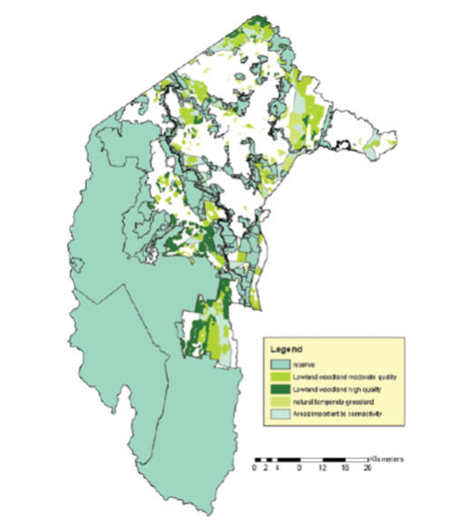
Source: DECCEW 2010.
Future work is required to improve connectivity between ecological communities through corridors and "stepping stones" of habitat, including integration with conservation outside of reserves. The 2010 review of Action Plan No. 27 has identified that the results of the connectivity work will be integrated into the ACT planning process and used in assessment of current development options. It is important to ensure that this happens and is updated on an ongoing basis as new information becomes available.
Protected Area management
The Nature Conservation Act provides for the protection and conservation of native plants and animals, declaration of threatened species and ecological communities. Over 50% of the ACT is protected within conservation areas. However, protected areas in themselves cannot guarantee the ongoing survival of threatened species or ecological communities. Effective adaptive management through monitoring and assessment is needed to ensure protected areas are restored or maintained in a good condition.
The large areas of reserves in the ACT are a major management challenge. In 2010-11, the ACT Government's budget for the environment was $40.8 million, which represents just over 1% of the ACT Government's total budget (OCSE 2011b). Of this, $8 million is spent on the management of Canberra Nature Park, and half of that is committed to implementing the Bushfire Operational Plan on reserves, restricting funds available per hectare for conservation and visitor programs (OCSE 2011b). A recent comparison of population, area of nature/conservation reserves (hectares), funding in Hobart City Council, Brisbane City Council and Canberra found that while overall more funds are invested in nature reserves in the ACT, the ACT has four times the area of the reserves that are managed in Hobart, and the ACT has only around one-third of the population (and therefore a far smaller income from rates) of Brisbane (OCSE 2011b). With increasing demand and pressure on the ACT's protected areas, management will continue to be a significant challenge.
Recently a new Plan of Management has been gazetted for Namadgi National Park, which replaces the 1986 Plan of Management. Since the development of the 1986 Namadgi National Park Management Plan there have been a number of significant changes to political, social and environmental settings relevant to the management of the park, including:
- expansion of the area of Namadgi National Park in 1991 (extending the park in the north-west from Mt Aggie to Mt Coree and Mt Blundell); and
- inclusion on the Australian Government National Heritage List as part of the Australian Alps national parks (TAMS 2010b).
No expansions of boundaries or additions have been made during the current reporting period.
A new Plan of Management for Tidbinbilla is expected to be gazetted in 2011. When finalised, it will replace the existing 1999 Plan. The Tidbinbilla Nature Reserve has been increased to include Jedbinbilla, a former pine plantation, and Birrigai, a special purpose reserve for recreation and education. In addition, the Tidbinbilla Plan of Management is expected to address the proposed inclusion of part of the Gibraltar Pine Forest, which was destroyed during the 2003 bushfire and is no longer used as a pine plantation. Since the 2003 bushfire, extensive forest regeneration has occurred using native forest species. The proposed incorporation of this area into Tidbinbilla would connect this reserve with Namadgi National Park.
During the reporting period three new nature reserves (Callum Brae, Jerrabomberra West and Kama) have been added as Canberra Nature Park conservation reserves. In addition, approximately 80 ha have been added to existing reserves (TAMS). Two additional nature reserves (Kinlyside and Jerrabomberra East) have also been proposed for inclusion into the Canberra Nature Park. The boundaries of the proposed nature reserves have been established and are currently managed for conservation values by the ACT Territory and Municipal Services (TAMS).
The new Canberra Nature Park inclusions largely consist of Natural Temperate Grassland and Yellow Box-Red Gum Grassy Woodland. The areas of vegetation in each reserve are shown in Table 4. These areas are approximate only and are derived from ACT-wide mapping of these communities (TAMS).
Table 4. New reserve inclusions for the Canberra Nature Park since 2007
| Reserve name | Total area (ha) | Area of Grassland | Area of Box - Gum Woodland | Area of other lowland woodland, including secondary grassland |
|---|---|---|---|---|
| Callum Brae | 143 | - | 122 | - |
| Jerrabomberra West | 261 | 181 | 65 | 8 |
| Kama | 155 | 39 | 98 | 19 |
| Kinylside (proposed) | 226 | - | 117 | 95 |
| Jerrabomberra East (proposed) | 99 | 78 | - | - |
Source: TAMS
There is a need to update the Canberra Nature Park Management Plan (ACT Government 1999) to incorporate the new reserves. Many of the ACT's woodland reserves were established to preserve hilltop vegetation rather than woodland conservation values; thus many reserves incorporate heavily degraded areas. It is estimated that 10-20% of the Canberra Nature Park supports highly degraded woodland in need of restoration (TAMS 2010a).
Currently a research and restoration experiment is underway in the Mulligans Flat - Goorooyarroo Woodland. This site includes the largest and most intact example of this type of Yellow Box-Red Gum Grassy Woodland in the ACT. The experiment aims to identify methods to restore the structure and function of temperate woodlands and increase biodiversity, and the intention is to support park managers in their work to conserve woodlands (Manning 2011). The experiment is a partnership between teams from the ANU, the ACT Government and CSIRO. See the Native species - fauna indicator cluster paper for more information.
The conservation of Endangered Ecological Communities in the ACT is an important part of protecting natural values and maintaining healthy ecosystems. Ensuring these ecological communities are retained in the ACT largely depends on eliminating or mitigating processes that result in habitat loss through urban development, fire regimes and climate change. These processes are largely identified through research and are currently managed by the ACT Government through the implementation of recovery actions, strategies and Action Plans. The Nature Conservation Act does not specify that Action Plans should include monitoring provisions to gauge their success; however, the plans generally include such a provision. Similarly the Act does not include a requirement or process to monitor and report progress on implementing Action Plans at periodic intervals. Existing ACT Action Plans for Endangered Ecological Communities include:
- Action Plan No. 27 - ACT Lowland Woodland Conservation Strategy - this strategy is focused on the protection of the remaining lowland grassy woodlands; it is also the statutory Action Plan for 11 species of plants and animals declared threatened under the Nature Conservation Act;
- Action Plan No. 28 - ACT Lowland Native Grassland Conservation Strategy - this strategy seeks to maintain and improve the natural integrity of the remaining lowland native grassland ecosystems; it also supersedes 7 separate Action Plans for ecological communities and species declared threatened under the Nature Conservation Act; and
- Action Plan No. 29 - ACT Aquatic Species and Riparian Zone Conservation Strategy - this strategy is focused on the protection and management of the rivers and riparian areas in the ACT that support threatened species and ecological communities; it is also the statutory Action Plan for 6 species of plants and animals declared threatened under the Nature Conservation Act.
The 3 Action Plans are complementary and recognise that ecological communities are dynamic; they change over time and integrate with each other. Each of these Action Plans has 5-year periods of action. Progress has been made on implementing the priority actions in the three comprehensive Action Plans released between 2004 and 2007. Action Plan No. 27 and Action Plan No. 29 were reviewed in 2010, and Action Plan No. 28 was reviewed in 2008, and the reviews indicate that the majority of the actions in the plans have been implemented or are ongoing. As such the plans are considered to be achieving their goals. For a summary of priority actions, progress and outcomes achieved during the review period see Table A1 in the Annex.
Lowland native grassland management
The Report on the Investigation into the ACT Lowland Native Grassland Investigation by the Office of the Commissioner for Sustainability and the Environment (OCSE 2009) made 32 recommendations to improve the protection and management of ACT Lowland Native Grasslands. The ACT Government agreed or agreed in principle with all recommendations. By the end of the reporting period, 14 of these recommendations had been fully implemented. The review of the Nature Conservation Act is expected to address a number of land-management matters recommended by the Commissioner's report. Other key actions that have advanced lowland native grassland protection and management include (OCSE 2011b):
- the Kama Woodland/Grassland (central Molonglo River Valley) was provisionally registered in 2009 under the Nature Conservation Act;
- the following grassland sites have been registration by the ACT Heritage Council: Tuggeranong Parkway Road Cutting, Small Purple Pea Habitat, Cotter Caves and Surrounds, and Button Wrinklewort Habitat; the Lower Molonglo Geological Site is provisionally registered; 2 nominations for Grassland Earless Dragon Habitat (Jerrabomberra Valley and Majura Valley) and Natural Temperate Grassland Ecological Community (Lawson and Majura Valley) are currently being assessed for provisional registration;
- during 2010-11 prescribed burns were undertaken for ecological reasons in a number of Lowland Native Grasslands sites; monitoring of these and other burns will provide information about the applicability of a wider program of ecological burning in Native Grasslands in the ACT;
- grazing on rural leases and licence areas containing high conservation grasslands is only permitted after consultation with grassland ecologists who review the proposals against conservation management strategies; their advice is included in the conditions attached to the grazing agreements;
Still to be implemented are: the development of an offsets policy and tool; making the location of sites publicly available; and ensuring assessment and adaptive management are implemented (OCSE 2011b). These would strengthen the management of Lowland Native Grassland in the ACT.
Independent Conservation Trust
Recently the ACT Government has undertaken a new approach to conservation management through the Capital Woodland and Wetlands Conservation Trust. This trust is a partnership between Government and the community and it aims to access private sector and community funding for projects located on public land, over and above normal government-funded operations. The Trust is being established to support projects in the Jerrabomberra Wetlands Nature Reserve and Mulligans Flat Woodland Sanctuary. The Trust is intended to supplement, rather than replace, annual government support for normal, ongoing management of these areas (OCSE 2011b). For more information see the Native species - fauna indicator cluster paper.
Community engagement
Community groups make an important contribution conservation management in the ACT with activities ranging from biodiversity conservation and species surveys, to water-quality monitoring and pest and weed control. This voluntary work has financial value (OCSE 2011b):
- the number of hours of voluntary work undertaken in Canberra Nature Park, Molonglo River Corridor and Googong Foreshores in the 2009-10 financial year was approximately 14,530 hours; and
- multiplying by an indicative payment rate of $25 per hour, the value is $363,250 (OCSE 2011b:97-98).
For more information on the role of community groups in conservation see the Community engagement indicator cluster in the People theme.
Glossary [top ]
Ecological community naturally occurring assemblage of plant and animal species occupying the same geographical area
Forb: a herbaceous flowering plant that is not a graminoid (grasses, sedges and rushes)
Perverse: a behaviour that is a deviation from what is considered orthodox or normal.
Vegetation community: assemblage of plant species within a designated geographical area, which forms a relatively uniform patch of vegetation, distinguishable from neighbouring patches of different vegetation types
References [top ]
ACT Government 1999. Canberra Nature Park Management Plan. Canberra. http://www.tams.act.gov.au/__data/assets/pdf_file/0019/145324/canberranatureparkmanagementplan1999.pdf (accessed 6/6/11)
ACT Government 2008. ACT Lowland Grassland Conservation Strategy Action Plan 28. Canberra. http://www.tams.act.gov.au/play/pcl/conservation_and_ecological_communities/grassland_conservation_strategy (accessed 27/7/11)
ACT Government 2010a. ACT Aquatic Species and Riparian Zone Conservation Strategy Action Plan 29. Canberra. http://www.tams.act.gov.au/play/pcl/conservation_and_ecological_communities/aquatic_species_and_riparian_zone_conservation_strategy (accessed 27/7/11)
ACT Government 2010b. ACT Lowland Woodland Conservation Strategy- Action Plan 27. Canberra http://www.tams.act.gov.au/play/pcl/conservation_and_ecological_communities/woodlands_strategy (accessed 27/7/11)
ACT MRC 1998. ACT Murrumbidgee River Corridor Management Plan. Department of Urban Services. ACT Government. Canberra. http://www.tams.act.gov.au/__data/assets/pdf_file/0020/201467/MRC_Plan_of_Management.pdf (accessed 1/5/11)
ACTEW 2011. Lower Cotter Catchment - 2010 Vegetation Assessment. ActewAGL. Canberra
CPR 2010. Planning and Research for Nature Conservation 2009-2010 Report .Conservation Planning and Research. Land Management and Planning. Territory and Municipal Services. ACT Government. Canberra. http://www.environment.act.gov.au/__data/assets/pdf_file/0007/236842/CPR_Annual_Report_2009-2010_V4-Pics_compressed.pdf (accessed 11/11/11)
DECCEW 2007. Draft Policy Statement: Use of Environmental Offsets Under the Environment Protection and Biodiversity Conservation Act 1999. Canberra
DECCEW 2010. Review of the Nature Conservation Act 1980 Discussion Paper. Canberra. http://www.environment.act.gov.au/__data/assets/pdf_file/0005/209984/Review_of_the_Nature_Conservation_Act_Discussion_Paper_WEB.pdf (accessed 5/9/11)
Manning, A.D., Shorthouse, D.J., Stein, J.L. and Stein, J.A. 2010. Technical Report 21: Ecological Connectivity for Climate Change in the ACT and Surrounding Region. Fenner School of Environment and Society. Australian National University. Canberra .
Manning, A. 2011. Mulligans Flat - Goorooyarroo Woodland Experiment. Australian National University. Canberra. http://people.anu.edu.au/adrian.manning/aboutMFGO.html (accessed 23/11/11)
OCSE 2009. Report on ACT Lowland Native Grassland Investigation. Office of the Commissioner for Sustainability and the Environment. Canberra. http://www.envcomm.act.gov.au/__data/assets/pdf_file/0011/169256/ocse_actgrasslandreport_0309_noappendices.pdf (accessed 1/12/11)
OCSE 2011a. Report on the Investigation into the Government's Tree Management Practices and the Renewal of Canberra's Urban Forest. Office of the Commissioner for Sustainability and the Environment. Canberra. http://www.envcomm.act.gov.au/__data/assets/pdf_file/0006/219354/OCSE_TreeInvestigation_Part1_ReportV5_28February2011.pdf (accessed 15/7/11)
OCSE 2011b. Annual Report 2010-2011. Office of the Commissioner for Sustainability and the Environment. Canberra. http://www.envcomm.act.gov.au/__data/assets/pdf_file/0016/233260/2010-11_OCSE_annual_report_for_Web.pdf (accessed 2/8/11)
OCSE 2011c. Report on the Canberra Nature Park (Nature Reserve); Molonglo River Corridor (Nature Reserves) and Googong Foreshores Investigation. Office of the Commissioner for Sustainability and the Environment. Canberra http://www.envcomm.act.gov.au/__data/assets/pdf_file/0006/234987/Part_I_Report.pdf (accessed 5/10/11)
Sharp, S. 2011. Landscape Function in Canberra Nature Park and Impacts of Threatening Processes on Landscape Function. Report for the ACT Office of the Commissioner for Sustainability and the Environment. Canberra
Sharp, S. Macdonald, T., Margaret, K. and Dunford, M. 2007. Setting Conservation Targets for Vegetation Communities in the ACT. Report to Natural Resource Management Council. Parks, Conservation and Lands. ACT Government. Canberra
TAMS 2004. Action Plan No. 27 - ACT Lowland Woodland Conservation Strategy. Environment ACT. ACT Urban Services. ACT Government. Canberra. http://www.tams.act.gov.au/__data/assets/pdf_file/0014/13604/actionplan27t1.pdf (accessed 5/6/11)
TAMS 2005. Action Plan No. 28 - ACT Lowland Native Grassland Conservation Strategy. Environment ACT. Urban Services. ACT Government. Canberra. http://www.tams.act.gov.au/__data/assets/pdf_file/0011/13016/actionplan28visionandcontents.pdf (accessed 11/4/11)
TAMS 2010a. ACT Woodland Restoration Implementation Plan. Territory and Municipal Services. ACT Government. Canberra
TAMS 2010b. Namadgi National Park Plan of Management. Territory and Municipal Services. ACT Government. Canberra. http://www.tams.act.gov.au/__data/assets/pdf_file/0019/200548/Final_NNP_Plan_151010_-_web_version.pdf (accessed 6/6/11)
Webb, B. 2011. Impacts of Climate on the Canberra Nature Park: Risks and Responses. Report for the ACT Office of the Commissioner for Sustainability and the Environment. Canberra http://www.envcomm.act.gov.au/__data/assets/pdf_file/0004/220477/OCSE_ANU_paper_climate_CNP.pdf (accessed 1/12/11)
WWF 2011. Building Nature's Safety Net 2011: The State of Protected Areas for Australia's Ecosystems and Wildlife. World Wildlife Fund. http://assets.wwfau.panda.org/downloads/bi037_building_natures_safety_net_2011_6jul11.pdf (accessed 1/9/11)
Other data sources
In addition to these published reports, data for this paper were also sourced from:
- Department of Sustainability, Environment, Water, Population (DSEWPaC)
- ACT Department of Territory and Municipal Service (TAMS) - now Territory and Municipal Service Directorate (TAMSD)
- ACT Department of the Environment, Climate Change Energy and Water (DECCEW) - now Environment and Sustainable Development Directorate (ESDD)
- Parks, Conservation and Lands (PCL) - now part of the Environment and Sustainable Development Directorate (ESDD)
Annex [top ]
Table A1. Summary of Action Plan implementation reviews
| Action Plan No. 27 - ACT Lowland Woodland Conservation Strategy 2007-2009 | |
|---|---|
| Monitoring Priority Actions | Progress and/or Outcomes of the Action |
| Completing surveys of woodlands including data collection on groundlayer and understorey vegetation and habitat characteristics. | 2924 woodland polygons mapped spatially and entered into a data base. |
| Protecting key habitat areas in Hall – Kinlyside, Gooroo, East Majura Valley and Callum Brae, and off-reserve areas such as Castle Hill (Tuggeranong – Naas complex). | Since 2003, reserves have been established at Callum Brae (414 ha) and Goorooyarroo (701 ha). Kinlyside (201 ha) is being managed for conservation. |
| Establishing mechanisms to assist in the application of best practice management (CMNs, voluntary management agreements, guidelines) to facilitate conservation outcomes on reserve and off-reserve land. | CPR monitoring of 15 Natural Temperate Grassland and Lowland Woodland reserves is measuring species richness, abundance and cover. |
| Threat Priority Actions | Progress and/or Outcomes of the Action |
| Reviewing management of lowland woodland areas in government horse paddocks and agisted land to ensure ecological condition is improved. |
Woodland condition and distribution on horse paddocks and agistment land has been assessed and mapped. Future work is required to assess the extent and nature of changed management practices to enhance ecological condition in government horse paddocks. |
| Protection Priority Actions | Progress and/or Outcomes of the Action |
| Protecting key habitat areas in Hall (Kinlyside), Goorooyarroo, East Majura Valley and Callum Brae, and off-reserve areas such as Castle Hill (Tuggeranong – Naas complex). |
Since 2003 reserves have been established at Callum Brae (414 ha) and Goorooyarroo (701 ha). Kinlyside (201 ha) is being managed for conservation. |
| Protecting examples of Snow Gum lowland woodland, especially ecotones between woodland and grassland. |
This priority has been applied in planning decisions (e.g. Kings Highway deviation) but no new Snow Gum lowland woodland has been added to the reserves system. Nomination to list Snow Gum Woodland as an Endangered Ecological Community was rejected by the ACT Flora and Fauna Committee: at the time of nomination not enough information was available to make an assessment. |
| Assessing woodlands for their potential for listing on the ACT Heritage Places Register as natural heritage places. | A draft nomination has been completed; stakeholder consultation is occurring. |
| Action Plan No. 28 - ACT Lowland Native Grassland Conservation Strategy 2005-2008 | |
| Monitoring Priority Actions | Progress and/or Outcomes of the Action |
|
The location, type and ecological condition of all Natural Temperate Grassland and habitat for threatened species in the ACT are described and the information kept current. |
Vegetation surveys of all known Natural Temperate Grassland sites have been undertaken and data are maintained in the ACT Vegetation Database. |
|
A comprehensive database of Natural Temperate Grassland and component species in the ACT is maintained. ACT data are included in national, state and community databases. |
The ACT checklist of vascular plants has been prepared by the Australian National Herbarium (ANH) and will be maintained on the ANH website. This will be an important reference for managers and researchers. |
| Threat Priority Actions | Progress and/or Outcomes of the Action |
| Substantially reduce or eliminate threats to natural temperate grassland through appropriate planning and management actions. |
Fire suppression guidelines have been developed for ACT declared threatened species and communities. The guidelines will be used in fire management and fire suppression operations to ensure fire managers are aware of appropriate techniques to apply to prevent damage to threatened species and communities. Data on threatened species locations have been updated and generalised maps prepared for use in fire management. An ACT Kangaroo Management Plan is being prepared and it will address conservation issues associated with kangaroo grazing pressures. |
| Reduce the impact and occurrence in grasslands of weeds of concern. | Annual weed programs of all Territory and Commonwealth land managers include, as a priority, weed control in areas of Natural Temperate Grassland and threatened species habitat. |
| Protection Priority Actions | Progress and/or Outcomes of the Action |
| A comprehensive, adequate and representative system of Natural Temperate Grassland areas in the ACT is protected by reservation, or other measures where reservation is not practical or desirable. | About 400 ha of grasslands in the Jerrabomberra valley have been identified for reservation. The Territory Plan has been amended to include these areas in nature reserves, except for Jerrabomberra East (about 125 ha) which is currently being surveyed to prepare a Draft Variation to the Territory Plan. |
| The ACT Heritage Places Register includes natural temperate grassland and key habitats for threatened grassland species. |
All Natural Temperate Grassland sites have been nominated for heritage listing and are being considered by the ACT Heritage Council. Not finalised at time of writing. |
| Action Plan No. 29 - ACT Aquatic Species and Riparian Zone Conservation Strategy 2008-2010 | |
| Monitoring Priority Actions | Progress and/or Outcomes of the Action |
| Comprehensive survey undertaken of riparian vegetation and habitat for high priority areas. |
Riparian vegetation composition determined, condition assessed, and management needs assessed and mapped. A Murrumbidgee report and a major tributaries report has been produced, with included maps. |
| Vegetation monitoring program designed and commenced for priority species/ecological communities. | Method trialled, yet to be implemented. |
| Survey and other relevant data entered into ACT vegetation database within 6 months of collection. | Ongoing |
| Extent of recovery of fire affected riverine and riparian ecosystems and ecological communities reported. |
Commentary provided in annual fish species reports. |
| Threat Priority Actions | Progress and/or Outcomes of the Action |
| Actions to address threats have been prepared and are being implemented. | Lower Cotter Catchment revegetation program (ACTEW 2011) to help address sedimentation. |
| Area of riparian zone occupied by weeds has been reduced. Incidence of high priority weeds has been reduced and their spread controlled. | Significant reduction in environmental weed cover at the locations mentioned. |
| Threats to rivers and riparian areas are substantially reduced or decreasing. | Ongoing |
| Protection Priority Actions | Progress and/or Outcomes of the Action |
| Conservation status of aquatic and riparian species and ecological communities assessed. Where appropriate, threatened species nominations prepared. |
Reports prepared annually that include assessment of status of different species. |
| Key riverine and riparian habitats are protected by legislation, reservation, planning and management actions. |
Murrumbidgee River Corridor largely protected in nature reserve. |
| Extent to which development proposals are assessed under applicable legislation. |
Assessments under Planning and Development Act and EPBC Act undertaken and expert comments provided. |
| Rivers and riparian zones have been assessed for suitable entries to the ACT Heritage Places Register and nominations prepared (2010-2012). | No progress to date. |
Source: ACT Government 2008, 2010a, 2010b


Share this page: