Regional Snapshot - Land Management
Land Management – Protecting Our Land Resources
Australia’s third largest region, the Australian Capital Region (ACR) supports a diverse range of land-uses (refer Figure 1). It has a total area of 6.7 million hectares, a population of 571,561 people, and a population density of approximately 11 hectares per person. In fact, the ACR is the third most populous non-metropolitan region in Australia, following the NSW Hunter region (626,000) and the Qld Gold Coast (903,000). Land use is diversified across agriculture, forestry, and national parks. However, the region also includes sizeable urban centres, such as Queanbeyan and Goulburn. Tourism and recreational land-use are major contributors to the regional economy with much of the Alpine area and large tracts of coastal land designated as national park and reserves.
Figure 1: Different Landuses in the Region
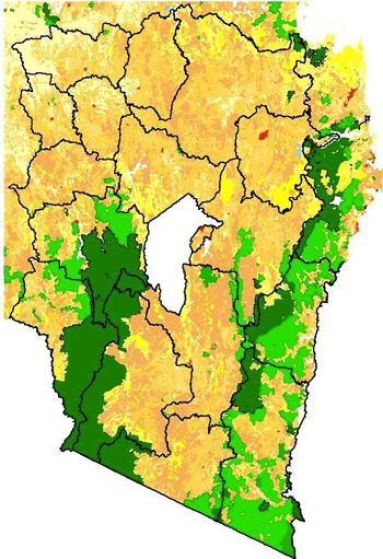
Source: NSW Department of Lands, 2008
Effective policy and governance in combination with community engagement, are essential elements in effective land management. At the local and regional level, managing our land resources is an important focus for councils. The involvement of many different stakeholders adds to the challenge of developing and implementing sustainable land management.
Numerous pressures affect the ACR landscape: population, drought and rural, residential and peri-urban development. These changes act as stressors on soils, biodiversity, water resources and infrastructure. As competition for land resources increases, we need to ensure that we do not impede the future capacity of our land. Consequently, we need to become more innovative in how we plan and develop our communities, especially in light of changing demographics.
The ACR’s soils vary in quality, fertility and resilience. For example, particular soils are more suitable for agriculture, forestry or urban uses. To make the most efficient use of our land, and to minimise potential damage to the surrounding environment, the various pressures that affect land productivity need to be well understood.
The land’s capacity to support a given use needs to be accounted for when developing land management strategies and assessing new developments. Partnerships between governments, community and industry groups will be of increasing importance as these land-use issues extend beyond Council borders.
Our land resources are affected by both natural and human processes, especially erosion and salinity. For example, erosion is a natural process that can be accelerated by human activities, such as vegetation removal, crop cultivation, mining, fires, earthworks and livestock grazing.1
Salinity, another major land management issue, is the result of widespread land clearing. The increased presence of shallow-rooted annual crops and pastures results in less water being drawn from the ground and greater water uptake, in soils, following rain. The effect is a rise in the water table. As it rises, the groundwater dissolves salt in the soil and brings it to the surface. This saline water kills native vegetation, reduces biodiversity, results in loss of agricultural productivity, and damages infrastructure.2 Salinity affects numerous parts of the ACR. Consequently, sustainable land management, for example Boorowa’s River Recovery Project, is critical to the region’s future productivity.
Weed control is also a major regional sustainability issue. Weeds displace native species, accelerate land degradation, and reduce farm and forest productivity, as they compete with native plants for space, nutrients and sunlight.3
Council Responses
Sustainable land management should be a key focus for local councils. It calls for appropriate planning and collaboration, especially with local Catchment Management Authorities and community groups.
Councils are encouraged to undertake the following actions:
- Work with the CMA and NSW Department of Primary Industries to identify effective and high-risk landuses, and implement appropriate planning controls.
- Continue to support and encourage community revegetation projects in the region.
- Understand, identify and take action to reduce salinity risks, for example, by avoiding excess irrigation and planting more deep-rooted vegetation
- Encourage farmers and landowners to maintain adequate ground cover to reduce wind and/or water erosion
- Plan and implement effective fire management strategies
References and Footnotes
1 NSW Department of Primary Industries, 2005, Saving Soil – A Landholder’s Guide to Preventing and Repairing Soil Erosion, viewed at http://www.dpi.nsw.gov.au/agriculture/resources/soils/erosion/saving-soil
2 Swinton, Gibbs and Grogan, 2000, Irrigation Salinity Facts, viewed at http://www.dpi.nsw.gov.au/__data/assets/pdf_file/0006/168891/reusing-irrigation-water.pdf
3 Weeds in Australia, 2009, viewed at http://www.weeds.gov.au/