Palerang
Indicator: Water Use
Results for this indicator are also available for [an error occurred while processing this directive]
Please note: Text or data highlighted in this colour represent an update to this indicator for the period 2008/09.
What the results tell us for Palerang
Water use of potable water supplied by Council over the last five years has been similar each year, with no clear trends. Water restrictions and conservation measures have been imposed, but their effect cannot be identified. The population supplied with reticulated water has increased over this period, which the Council has estimated to be a 3.8% increase per annum. It is likely that a small decrease in per capita consumption balanced the population increase. There is no current re-use of treated wastewater.
Supply- how much water could we have?
Palerang Council supplies reticulated potable water to the three main villages in the Council area, Bungendore, Braidwood and Captains Flat. Water is drawn from the Shoalhaven River to supply the Braidwood Dam, which holds 80 ML. The dam is operated at full capacity. Water for the reticulated supply is chlorinated, but receives no other treatment.
The Captains Flat dam is fed from the Molonglo River and has a capacity of 820 ML. This dam was originally constructed to supply a mining area, which is now closed. Water from this dam is micro-filtered and chlorinated.
Bungendore’s water supply is provided by bores, however no flow rates were provided. The water is aerated and chlorinated.
Palerang Council’s population is growing, and the additional Defence facility at Bungendore can be expected to stimulate further growth. The NSW Government licenses water allocations, including extraction rates for bores.
The provision of fluoridation to the reticulated water supplies is planned.
How much water was available?
It was estimated that 27% of the population, of about 13,900 (June 2008), is connected to reticulated water managed by Palerang Council. A few of these village residents also have private bores and an increasing number have rainwater tanks. The remaining 73% of residents use rainfall tanks, private bores, dams and creeks for water supply.
Consumption – how much water was used?
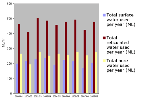
The current consumption of surface water from the Shoalhaven and Molonglo rivers, for reticulated supply to Braidwood and Captains Flat, is approximately 200 ML/Yr, with no clear trend in volume used. Similarly, Council-managed bore water use in Bungendore has been at a rate of about 265 ML/Yr. No data are available for surface water use in 2007-08.
| Total volume used ML/year | 2004-05 | 2005-06 | 2006-07 | 2007-08 | 2008-09 |
|---|---|---|---|---|---|
| Surface water (e.g. dams, reservoirs, rivers) | 191.5 | 221.8 | 214.1 | 170.5 | 202.8 |
| Reticulated water | 456.0 | 477.7 | 491.9 | 423.8 | 477.9 |
| Bore water | 264.5 | 255.9 | 277.8 | 253.38 | 275.1 |
Figures provided above are for Council controlled water supplies only. Records are not sought or kept by Council for private domestic systems.
Table 1 was added to include data for 2004-05 to 2008-09.
Figure 1. Total water use in Palerang Council area 2000-01 to 2008-09
Use by sector
| Town/Village | Sector | 2004-05 | 2005-06 | 2006-07 | 2007-08 | 2008-09 |
|---|---|---|---|---|---|---|
| Bungendore | Residential | 249.98 | 241.82 | 262.53 | 239.45 | 259.9 |
| Commercial | 7.94 | 7.68 | 8.33 | 7.60 | 8.3 | |
| Industrial | 3.97 | 3.84 | 4.17 | 3.80 | 4.1 | |
| Public parks | 2.65 | 2.56 | 2.78 | 2.53 | 2.8 | |
| Total | 264.53 | 255.89 | 277.813 | 253.383 | 275.1 | |
| Captain's Flat | Residential | 46.34 | 44.91 | 54.84 | 49.6 | 49.68 |
| Commercial | 1.14 | 1.10 | 1.35 | 1.22 | 1.22 | |
| Public parks | 0.00 | 0.00 | 0.00 | 0 | 0 | |
| Total | 47.48 | 46.01 | 56.189 | 50.82 | 50.9 | |
| Braidwood | Residential | 112.52 | 144.80 | 143.47 | 108.7 | 137.94 |
| Commercial | 5.15 | 6.63 | 6.57 | 5.03 | 6.38 | |
| Industrial | 2.07 | 2.66 | 2.64 | 2.03 | 2.58 | |
| Public parks | 4.12 | 5.31 | 5.26 | 3.95 | 5.01 | |
| Total | 123.87 | 159.40 | 157.94 | 119.71 | 151.91 | |
| Total for Palerang Shire area | Residential | 408.84 | 431.53 | 460.85 | 239.45 | 447.52 |
| Commercial | 14.23 | 15.41 | 16.25 | 7.60 | 15.9 | |
| Industrial | 6.04 | 6.50 | 6.80 | 3.80 | 6.68 | |
| Public parks | 6.77 | 7.87 | 8.04 | 2.53 | 7.81 | |
| Total | 435.87 | 461.31 | 491.94 | 423.91 | 477.91 |
Source: Palerang Shire Council
Table 2 was added to include data for 2004 -05 to 2008-09.
Figure 2. Palerang Council area reticulated water use by sector 2008-09
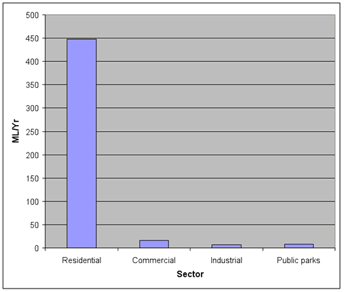
The graph above (Figure 2) for 2008-09, which is the last complete set of data, shows a typical distribution of water use by sector. It is apparent that domestic use accounts for almost all the reticulated water use in the Council area.
Environmental flows
The only environmental flow of potential importance is that from Captains Flat Dam down the Molonglo River. This river flows to Canberra and supplies Lake Burley Griffin with water. No data were provided.
Managing water demand and use
Water conservation
Both water restrictions and water conservation measures have been put in place in the Council area. Water restrictions follow the framework applied in Canberra and Queanbeyan. Restrictions and/or water conservation measures have been implemented in Bungendore for the entire four years of the current reporting period, and continuously since December 2006 for Braidwood and Captains Flat.
In Braidwood water restrictions applied at level 1 on 128 days in 2006-07, and 251 days in 2007-08. Water conservation measures applied for 84 days in 2006-07 and 114 days in 2007-2008. Since 8 March 2008 conservation measures equivalent to restrictions Level 1 or 2 have been in place.
In Captain’s Flat water restrictions applied at Level 1 on 119 days in 2007-08. Water conservation measures applied for 212 days in 2006-07, and 247 days in 2007-08. These are mandatory and equivalent to restrictions under Level 1 or 2.
Bungendore was put on Level 1 water restrictions in 2002-03, which applied for the whole year in 2003-04, 2004-05 and 2005-06. In 2006-07 they applied for 153 days, when Level 2 came into place for the rest of the year. In 2007-08 Level 2 restrictions applied for 247 days, followed by Level 3. Since March 2008 Bungendore has been on Level 2 restrictions.
Notwithstanding these restrictions, the volume of reticulated water used in the Council area rose from 456 ML/Yr in 2004-05 to 492 in 2006-07, the last year with comprehensive data available.
Recycling – making the drop go further
Currently no recycling of treated wastewater occurs in the Council area. Palerang Council has undertaken a Draft Development Servicing Plan for Braidwood Sewage Treatment Plant, to upgrade the facility. The Plan notes that it is proposed to replace the existing treatment plant in Braidwood because the quality of effluent does not meet the standard required by the NSW Department of Environment and Climate Change. It is also noted that the effluent from the new treatment plant may be reused for irrigation including the Braidwood golf course.
Laws and policy
Palerang Council area includes parts of the Southern Rivers and Murrumbidgee Catchment Authority areas. It is fully within NSW.
About the data
Quantitative data were received from Palerang Council.