Palerang
Atmosphere & Weather | Biodiversity | Catchments | Resources Use
Summary of updates to Palerang indicators for 2008/09.
Palerang Snapshots
These "snapshot" profiles celebrate recent environmental initiatives within this LGA.
Archive of 2008 snapshots for Palerang.
2009 Snapshots
1. A Changing Landscape – Capital Wind Farm
2. Environmentally Sensitive Areas Now Mapped
3. Royalla Riparian Restoration
A Changing Landscape – Capital Wind Farm
Construction of the Capital Wind Farm Project was undertaken during 2008/09 on ridges of the Great Dividing Range to the east of Lake George. A total of 63 wind turbines were constructed, along with associated facilities, in a project worth $220 million.
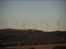
Capital Wind Farm turbines
Photo: Palerang Shire Council
While there were some environmental and community concerns about the proposed development, the New South Wales Department of Planning (NSW DoP) was satisfied that the potential impacts were able to be mitigated and managed.
The project was approved due to the environmental benefits that it will provide through green power generation. Each of the 2.1 megawatt turbines has a 90 metre diameter rotor mounted on an 80 metre tall tower. The farm will be capable of generating 405,600 megawatt hours per year of electricity (that’s enough to supply approximately 71,000 households for a year!). If the project displaces coal fired power generation it will offset the equivalent of about 390,000 tonnes of carbon dioxide (CO2) emissions per year. This is equal to removing 78,000 large cars off the street!
This project provides a sustainable and clean source of energy. Once established, wind power generation produces zero carbon dioxide emissions, and it takes only approximately seven months of operation to offset the energy used in its manufacture, transportation and construction. (see regional snapshot)
Environmentally Sensitive Areas Now Mapped
Palerang Council has undertaken an important assessment over the past year to identify, rate and map environmentally sensitive areas across the Council.
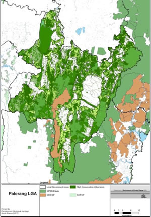
Palerang LGA map of sensitive areas
This assessment was completed with assistance from the former New South Wales (NSW) Department of Environment and Climate Change, NSW Department of Water and Energy, and NSW Department of Primary Industries. The Environmentally Sensitive Areas Overlay will be used as a basis for a “whole of landscape approach” to strategic planning for biodiversity protection and enhancement.
The outcomes of this project will result in better identification and protection of riparian corridors, identification of existing conservation and vegetation values and identification of potential future conservation corridors. By identifying these areas, Palerang Council will be better able to plan and protect for the environment. The map overlay will be incorporated into the new Palerang Local Environmental Plan, which is currently under development.
Royalla Riparian Restoration
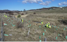
Revegetation work
In 2008/09, Palerang Council commenced the Palerang Riparian Restoration Program at three public land sites along waterways at Royalla, Carwoola and Bungendore. The site in Royalla involves weed removal and revegetation at Royalla Park, along Jerrabomberra Creek Reserve and some adjacent private land. The program is being coordinated by Palerang Council with funding from the Australian and NSW Governments via the Murrumbidgee Catchment Management Authority, along with support by local community organisations.
The program’s objectives are to improve water quality through reduced in-stream sediment and improved biodiversity. This will be achieved by reducing weeds and planting native vegetation along the creek.
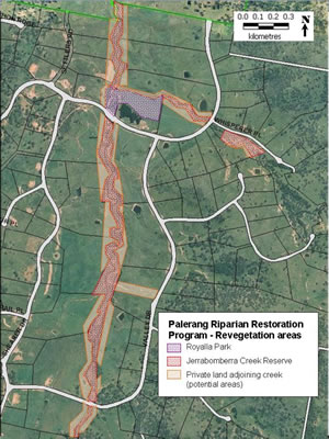
Palerang riparian restoration program revegetation areas
The map below shows the location of the proposed works. The general areas and proposed works are as follows:
1. Royalla Park, including the open area north of the elm wood and recycle bins, extending west and north across the creeks. Noxious weeds will be controlled and small native woodlands including recreational access paths established.
2. Jerrabomberra Creek Reserve, including along the main Jerrabomberra Creek and side gully near Whisperer Place. Noxious weeds will be controlled where accessible and native trees/shrubs/grasses/forbs planted on top of the bank to complement Royalla Landcare gully plantings.
Works on private land adjoining Jerrabomberra Creek Reserve are subject to agreements with individual landholders. The program will provide funding for ground preparation and tubestock planting with guards and fencing materials. Landholders will be required to erect protective fences and maintain the plants.
In addition, Palerang Council has been working with Royalla Landcare, who received a Highly Commended Award at the 2009 Murrumbidgee Regional Landcare Awards, to support ongoing efforts to restore the local environment along the creek. Over the coming year, the Riparian Restoration Program will plant 8,300 native seedlings to create woodlands at the Royalla Park and habitat corridors along approximately 5 km of the creek.
Palerang Council is also being supported by local volunteers. This program will help achieve significant local environmental improvements through improved bank stability, reduced erosion and sediment pollution, and improved biodiversity.