Palerang
Indicator: Population
Results for this indicator are also available for [an error occurred while processing this directive]
What the results tell us for Palerang
Palerang Council area remains relatively static with only a small percentage in growth observed. According to the 2006 Census there were 12,913 residents in the Council area with an estimated 13,419 in 2007. Since the end of the previous State of the Environment Reporting period, the population of the Council area is estimated to have risen by 3.7% per year or 1,459 persons over the three years to June 2007.
Compared with New South Wales (NSW), Palerang has a higher aged population, a lower Indigenous population and a slight decrease in the proportion of persons born overseas. Along with many other jurisdictions in Australia, Palerang Council will need to consider the impacts of an ageing population on its economy, and infrastructure.
The composition of households has continued the trend noted in the 2004 report with a further reduction in the number of households comprising couples with children and a consequent increase in couples without children and also lone person households. These are similar to trends observed in other Councils. Palerang Council’s Social Plan is committed to addressing these issues.
Population is growing in number and age
The population in Palerang Council area was 12,913 at the 2006 Census (Table 1). Based on the latest available ABS figures (2008), it can be seen that the population rose by 1,459 persons since 2004, or a growth of 3.7% for the period, compared with 0.7% average for the Australian Capital Region for the period, and 0.8% for NSW. Compared with all local government areas across the State, the Council area ranked 2 out of 149 for the fastest growth and 49 out of 152 for the largest growth. Figure 1 illustrates the population for the years 2004 to 2007, showing the annual estimated residential population at 30 June for each year.
| 2004 | 2005 | 2006 | 2007 | Population Change2004-2007 |
|---|---|---|---|---|
| 11,960 | 12,329 | 12,913 | 13,419 | 1,459 (3.7 % p.a.) |
See About the data for Australian Bureau of Statistics comments on years 2001-2007;
Source: Australian Bureau of Statistics Catalogue No. 3218.0 (2008)
Figure 1. Population growth, Palerang Council area, 2004 to 2007
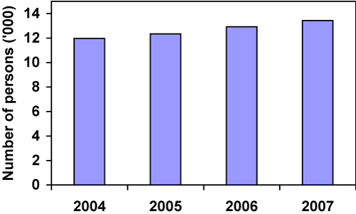
Source: Australian Bureau of Statistics Catalogue No. 3218.0 (2008)
Since the 2004 report, the Palerang Council area has experienced a small increase in population but the population demographic is continuing the trend of decreasing youth and increasing ‘middle’ and older persons. The decreasing youth was noted in the last report but has now decreased a further 2.6% since 2001 and 2.5% compared to the 1996 level. The ‘middle’ age group increased by 1.6% (1996-2006) with 1.3% of this increase occurring since 2001. The proportion of the population aged 65+ increased by 1.3% compared with the 0.7% increase during the earlier period (1996-2001). The median age as at 2006 was 39 years in Palerang Council area compared with the State median of 37 years. In 2001 the median was 38 with 35 for the State, and in 1996, 36 and 34 years respectively. Percentages and figures are illustrated in Table 2.
These trends are similar to those evident in other Councils in the Region and will have resultant impacts on the Council’s healthcare, social, economic and transport needs into the future.
| Age | 1996 | 2001 | 2006 | |||
|---|---|---|---|---|---|---|
| No. | % | No. | % | No. | % | |
| <15 years | 2,440 | 25.8 | 2,694 | 24.9 | 2,757 | 22.3 |
| 15–64 years | 6,307 | 66.7 | 7,256 | 67.0 | 8,459 | 68.3 |
| 65+ years | 703 | 7.4 | 881 | 8.1 | 1,171 | 9.4 |
| Totals | 9,450 | 100 | 10,831 | 100 | 12,387 | 100 |
See About the data for Australian Bureau of Statistics comments on this table;
Source: Australian Bureau of Statistics Census 2006 Time Series Profile Catalogue No. 2003.0
Ethnicity and diversity
Gender
Palerang Council area’s population as at the 2006 Census was split 50.62% male and 49.38% female. Compared with the gender distribution for NSW (49.3% males to 50.7% females), the Shire’s population reverses the trend observed in the State and other Councils. See Figures 2 and 3 for a comparison of the gender and age distribution for the Shire and NSW respectively.
Figure 2. Age and sex distribution, Palerang Council area, 2006
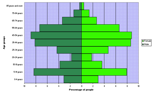
Source of data: Australian Bureau of Statistics Census 2006 Time Series Profile Catalogue No. 2003.0
Figure 3. Age and sex distribution, New South Wales, 2006
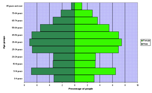
Source of data: Australian Bureau of Statistics Census 2006 Time Series Profile Catalogue No. 2003.0
Origins
In 2006, 84.2% of Palerang Council area’s non-Indigenous residents were born in Australia, compared with 83.3% in 2001 and 84.6% in 1996 (Table 3). By comparison, NSWs has experienced a drop of about 1% between Censuses (1996, 2001, and 2006). The proportion of Iindigenous population for the Council area has fallen slightly since the last report to 0.9% from 1.0% in 2001, but still up from 0.6% in 1996. This is a lower percentage compared with the rest of the State (2.2%) in 2006. The ‘Born overseas’ group has reduced by 0.7% to 14.9% in the 2006 Census from 15.6% in 2001 compared with the gradual increase (0.65%) in proportion experienced by NSW as a whole.
| Origin | 1996 Census | 2001 Census | 2006 Census | |||
|---|---|---|---|---|---|---|
| No. | % | No. | % | No. | % | |
| Indigenous persons | 57 | 0.6 | 106 | 1.0 | 103 | 0.9 |
| Born in Australia | 7,757 | 84.6 | 8,606 | 83.3 | 9,841 | 84.2 |
| Born overseas (a) | 1,352 | 14.8 | 1,615 | 15.6 | 1,740 | 14.9 |
| Total | 9,166 | 100 | 10,327 | 100 | 11,684 | 100 |
See About the data for notes on (a);
Source: Australian Bureau of Statistics Census 2006 Time Series Profile Catalogue No. 2003.0
Households and family type
In 2006, 74.2% of the Council area’s residents lived in one-family households consisting of 36.3% couples with children, 31% couples with no children and 6.4% were one-parent families. About 18.3% of the population consisted of lone person households. (Table 4). These compositions are similar to the 2001 census. The group with the most significant percentage drop was the ‘One parent family’ group, having fallen by 0.6% since the 1996 Census but note that the real numbers of these households actually rose by 20. This anomaly is due to the increase in population in the Council area in 2006 compared to 2001.
| Household composition | 1996 Census | 2001 Census | 2006 Census | |||
|---|---|---|---|---|---|---|
| Dwellings | % | Dwellings | % | Dwellings | % | |
| One family household: | ||||||
| Couple family with children | 1,337 | 39.4 | 1,398 | 36.2 | 1,651 | 36.3 |
| Couple family without children | 1,006 | 29.6 | 1,194 | 30.9 | 1,407 | 31.0 |
| One parent family | 259 | 7.6 | 269 | 7.0 | 289 | 6.4 |
| Other family | 15 | 0.4 | 27 | 0.7 | 24 | 0.5 |
| Total | 2,617 | 77.0 | 2,888 | 74.8 | 3,371 | 74.2 |
| Miscellaneous households: | ||||||
| Group household | 71 | 2.1 | 75 | 1.9 | 70 | 1.5 |
| Lone person household | 594 | 17.5 | 707 | 18.3 | 831 | 18.3 |
| Other household (c) | 115 | 3.4 | 192 | 5.0 | 270 | 5.9 |
| Total | 3,397 | 100 | 3,862 | 100 | 4,542 | 100 |
For notes on (a), (b) and (c) see About the data;
Source: Australian Bureau of Statistics Census 2006 Time Series Profile, Catalogue No. 2003.0
Where people are working and what they are earning
The public administration and safety sector is the highest employer as at the 2006 census at 19.8%, an increase of 4.1% since the 2001 census compared to a State-wide increase of 0.8%. The construction sector is the next highest employer with 9.1% in 2006, an increase of 1.2% since 2001.
The agriculture, forestry and fishing sector has had the largest decrease falling 2.5% to 6.9% in 2006. As with other Councils in the area, the effects of the drought are impacting on this sector which has fallen by 0.7% for the State as a whole.
| Industry of employment (a) | 1996 Census | 2001 Census | 2006 Census | |||
|---|---|---|---|---|---|---|
| Persons | % | Persons | % | Persons | % | |
| Agriculture, forestry & fishing | 535 | 11.7 | 490 | 9.4 | 443 | 6.9 |
| Mining | 22 | 0.5 | 14 | 0.3 | 14 | 0.2 |
| Manufacturing | 237 | 5.2 | 294 | 5.6 | 325 | 5.1 |
| Electricity, gas, water & waste services | 27 | 0.6 | 47 | 0.9 | 71 | 1.1 |
| Construction | 282 | 6.2 | 414 | 7.9 | 579 | 9.1 |
| Wholesale trade | 167 | 3.7 | 147 | 2.8 | 147 | 2.3 |
| Retail trade | 346 | 7.6 | 379 | 7.3 | 529 | 8.3 |
| Accommodation & food services | 255 | 6.0 | 329 | 6.3 | 327 | 5.1 |
| Transport, postal & warehousing | 183 | 4.0 | 200 | 3.8 | 227 | 3.6 |
| Information media & telecommunications | 120 | 2.6 | 143 | 2.7 | 144 | 2.3 |
| Financial & insurance services | 89 | 1.9 | 81 | 1.5 | 126 | 2.0 |
| Rental, hiring & real estate services | 61 | 1.3 | 71 | 1.4 | 79 | 1.2 |
| Professional, scientific & technical services | 331 | 7.2 | 461 | 8.8 | 535 | 8.4 |
| Administrative & support services | 69 | 1.5 | 126 | 2.4 | 136 | 2.1 |
| Public administration & safety | 749 | 16.4 | 819 | 15.7 | 1,264 | 19.8 |
| Education & training | 371 | 8.1 | 427 | 8.2 | 498 | 7.8 |
| Health care & social assistance | 297 | 6.5 | 359 | 6.9 | 459 | 7.2 |
| Arts & recreation services | 67 | 1.5 | 85 | 1.6 | 104 | 1.6 |
| Other services | 188 | 4.1 | 189 | 3.6 | 230 | 3.6 |
| Inadequately described/Not stated | 168 | 3.7 | 135 | 2.6 | 146 | 2.3 |
| Total | 4,564 | 100 | 5,210 | 100 | 6,383 | 100 |
For notes on (a) see About the data;
Source: Australian Bureau of Statistics Census 2006 Time Series Profile, Catalogue No. 2003.0
About the data
Data for this indicator were sourced from the Australian Bureau of Statistics
Data for Table 1— Estimated Residential Population Australian Bureau of Statistics Catalogue No. 3218.0. Years 2004-06 are preliminary rebased figures, whereas 2007 figures are preliminary. The figure for 2004 was only preliminary at the time of writing the 2004 State of the Environment Report; therefore it has now been revised. As explained in the Extract from Explanatory Notes, Australian Bureau of Statistics—Catalogue No. 3218.0 (2008), ‘To meet the conflicting demands for accuracy and timeliness there are several versions of sub-state/territory population estimates. Preliminary estimates are normally available nine months after the reference date (i.e. March), revised estimates twelve months later and rebased and final estimates after the following census.' Estimated population is preliminary rebased for 2002 to 2006, based on results of the 2006 Census of Population and Housing, and preliminary for 2007. At the time of writing, final 2006 Census-based estimates for 2002 to 2006, together with the first revision of 2007 were not yet available.
Data for Table 2 – Selected Person Characteristics: Australian Bureau of Statistics, Time Series Profile (T01), Catalogue No. 2003.0, Commonwealth of Australia, 2006.
Data for Table 3 – Selected Person Characteristics: Australian Bureau of Statistics, Time Series Profile (T01), Catalogue No. 2003.0, Commonwealth of Australia, 2006, (a) Includes 'Australian External Territories', 'Inadequately described', 'At sea' and 'Not elsewhere classified'.
Data for Table 4 —Dwelling Structure by Household Composition and Family Composition: Australian Bureau of Statistics, Time Series Profile (T14), Catalogue No. 2003.0, Commonwealth of Australia, 2006 (a) The 'Household Composition' variable replaced 'Household Type', which was used in 1996 and 2001; (b) The 'Family Composition' variable replaced 'Family Type', which was used in 1996 and 2001; (c) Comprises 'Visitors only' and 'Other not classifiable' households.
Data for Table 5 — Industry types in Palerang Council Area: Australian Bureau of Statistics, Time Series Profile (T25), Catalogue No. 2003.0, Commonwealth of Australia, 2006. (a) Industry of employment was coded to the 2006 Australian and New Zealand Standard Industrial Classification (ANZSIC) edition. This has replaced the 1993 ANZSIC edition.
References
Australian Bureau of Statistics (2007) Regional Population Growth, Australia, 1996 to 2006, Catalogue No. 3218.0 — ‘Estimated Residential Population—30 June ', Commonwealth of Australia, http://www.abs.gov.au/
Australian Bureau of Statistics (2008) Regional Population Growth, Australia, 2006-07, Catalogue No. 3218.0 — ‘Population Estimates by Local Government Area, 2001 to 2007 — 30 June', Commonwealth of Australia, http://www.abs.gov.au/
Australian Bureau of Statistics (2006) Time Series Profile, Catalogue No. 2003.0, Commonwealth of Australia, http://www.abs.gov.au/