Palerang
Indicator: Land Use
Results for this indicator are also available for [an error occurred while processing this directive]
Please note: Text or data highlighted in this colour represent an update to this indicator for the period 2008/09.
What the results tell us for Palerang
Maps of land use in | 1997 | 2000 | 2004 | 2008 (see below)
How is the land being used now?
Of the total council area (514,447 hectares), the dominant landuses at the end of the reporting period were agriculture (43%), bushland (24%) and conservation (23%) (see Figure 1). Bungendore, Braidwood and Captains Flat townships comprised the majority of the urban land, covering less than 1% of the total area. The remaining areas are classed as timber production and waterbodies.
Figure 1. Major landuse in Palerang Council, June 2008
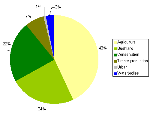
Source: Palerang State of the Environment Report 2004; Palerang Council
What has changed and why?
The only significant overall change is a 1% increase in land dedicated to conservation (see Table 1). There were minor decreases in area of agriculture, bushland and timber production, however these are not detectable when rounded to the nearest percentage of total council area. There has also been an increase in urban housing, particularly in Bungendore, however the area is insignificant as a percentage of the entire council area. In 2008-09 there was a slight increase in conservation land, mostly converted from bushland, due to an increase in the size of Morton National Park and some Property Vegetation Plans.
| Landuse Category | 1997 | 2000 | 2004 | 2008 |
|---|---|---|---|---|
| Agriculture | 43% | 43% | 43% | 43% |
| Bushland | 27% | 27% | 24% | 24% |
| Conservation | 13% | 13% | 22% | 23% |
| Timber production | 14% | 14% | 7% | 7% |
| Urban | 0.9% | 0.9% | 0.9% | 0.9% |
| Waterbodies | 3% | 3% | 3% | 3% |
Source: Palerang State of the Environment Report 2004; Palerang Council
Agriculture
The total amount of land classed as agricultural has remained quite stable since 1997 (see Table 1). Some areas of agricultural land are in the process of being converted to pine tree plantations for timber production, however the loss of agricultural land is estimated at only a fraction of a percent of the total Palerang area.
It is noted that land use maps produced for the 2004 report, including 2004 and preceding periods, were based on the original boundary of Palerang when first established in 2004. There has subsequently been a minor boundary adjustment with around 4,500ha added from Cooma-Monaro shire, of which about 1500ha was agricultural.
The broad class of agriculture includes productive agricultural land, mostly for grazing with limited areas of broadacre cropping in favourable years, and smaller rural-residential holdings. Rural residential holdings are an important characteristic of Palerang, particularly in the western areas close to Canberra. It is estimated that more than half of the shire’s population live on these small rural blocks. Some blocks are used for micro intensive agricultural pursuits such as grapes, olives, nuts and alpacas, whilst many others just hold a few horses for personal use or provide a spacious rural setting.
During the current reporting period there was a continual conversion of agricultural land from productive agriculture to smaller rural residential blocks, more noticably in the eastern areas of Palerang than in previous periods.
Timber production
Significant land use changes were reported during the previous period, from 2000 to 2004, when half of the timber production areas were converted to conservation as part of the Southern Regional Forest Agreement. Following on from that, there has been a further conversion of some timber production land to conservation at a much smaller scale. Simultaneously, there has been an increase in private pine plantation, so that overall the decrease in forestry production is only a fraction of a percent of the total Palerang area.
Bushland
A small area of bushland was converted to conservation during the 2008 reporting period. A boundary change that added part of the Cooma-Monaro shire to Palerang also added about 500ha of bushland. Overall there was a net decrease in area classed as bushland which totalled only a fraction of a percent of the Palerang area. During 2008-09 some bushland was converted to national park and conservation under Property Vegetation Plans.
Conservation
After a major increase in conservation land use during the previous reporting period, particularly from timber production plus some bushland, there was only a minor increase of about 1% of Palerang’s area from 2004 to 2008. This was largely a result of timber production and bushland areas being converted to conservation, including additions to Monga National Park and Bees Nest Nature Reserve.
It is noted that land use maps produced for the 2004 report, including 2004 and preceding periods, were based on the original boundary of Palerang when first established in 2004. A subsequent boundary adjustment transferred about 2500ha of conservation land, forming parts of Tinderry Nature Reserve and Yanununbeyan State Conservation Area, from Cooma Monaro to Palerang shire.
A number of Property vegetation plans have been registered with the CMAs during the 2004-09 reporting period.
During 2008-09 an additional 244ha near Nerriga was reserved as national park extending the northern end of Morton National Park within the Palerang local area.
Future planning
Palerang Council inherited five Local Environment Plans (LEPs) when it was formed in 2004, namely the Tallaganda LEP 1991, Yarrowlumla LEP 2002, Mulwaree LEP 1995, Gunning Shire Council LEP 1997, and Cooma Monaro LEP 1999 (Rural). Council is nearing completion of a new standardised LEP to cover the entire council area.
About the data
The landuse maps and statistics reported here were prepared either by Agrecon or the Office of the Commissioner for the Environment, using sources that included State Government agency and council data, and satellite image classification. The primary purpose of the mapping was to assess trends in landuse change and not to provide an accurate account of the actual areas changed.
Palerang Council provided Local Environment Plan information and cadastral data. In general the data provided by council and State Government departments showed a higher level of detail than satellite classifications. Therefore, these layers were usually used as the primary source of data and supplemented by satellite imagery (Landsat data and SPOT VI data) as needed (mostly for agricultural landuses and bushland).
All landuse maps for Palerang Council Area were provided to council for checking and correction, particularly for 2004 and 2000.
All percentages shown in this indicator are a percentage of the council area and not a percentage of the landuse type. The areal extents of the various landuse types (hectares) were calculated from data that had been adjusted (normalised) to take account of (usually minor) differences between the size of Palerang Council Area as gazetted by council, and the size calculated from spatial data.