Goulburn Mulwaree
Issue: Catchments
This issue is discussed for these areas: [an error occurred while processing this directive]
For more information refer to the following Indicators:
Contaminated Sites | Discharge to Waters | Groundwater | Land Degradation | Land Use | Surface Water Quality
How has Catchment Quality Changed?
Goulburn Mulwaree Council is located in the Southern Tablelands of New South Wales (NSW) in the Southern Rivers and Hawksbury Nepean Catchments. The Council covers an area of 3,232 km2 and has a population of approximately 27,000 people. The Council is known as a sheep grazing area that produces high quality, fine Merino wool. This is mixed with cattle grazing country and emerging wine regions.
Insufficient data was available for Goulburn Mulwaree Council area to assess changes to, or impacts on, many aspects of catchment quality over the current reporting period. As a result, changes in erosion and groundwater quality are not reported.
Drought was a significant event impacting on catchment quality in Goulburn Mulwaree Coucil area over the current reporting period. The drought, which commenced just prior to 1997, is as serious if not worse than other major prolonged droughts such as 1895 to 1903 and 1938 to 1945. Previous extreme drought years include 1902, 1914, 1938, 1940, 1944, 1967, 1982 and 2002. The 2006–07 irrigation season was a record dry season for much of the area.
As water availability has changed, water allocations within the catchment have been adjusted. Water allocations are made in a way that reflects the priority given to domestic and basic rights supplies, then to core environmental needs, then to irrigation and industry. Operational plans for 2007–08 reflect that the catchment experienced one of the lowest inflow periods in history. In many cases, high security licences were permitted to carryover unused water for the first time.
Drought or excessive water extraction causes water bodies to dry out, water quality conditions deteriorate and the fish within them may die or be eaten by birds. This scenario is unlikely for the main river channels, but is likely for many of the smaller creeks and tributaries. Indeed, many of the smaller creeks have already dried back to a series of disconnected pools.
Algal blooms are also more frequent during drought conditions due to low, slow flows.
During the drought, salinity levels are generally relatively low. This is due to little or no inflows from higher salinity tributaries and no return flows. Groundwater leakages from saline floodplains are generally also lower. However, if dilution flows continue to reduce, river salinity levels increase.
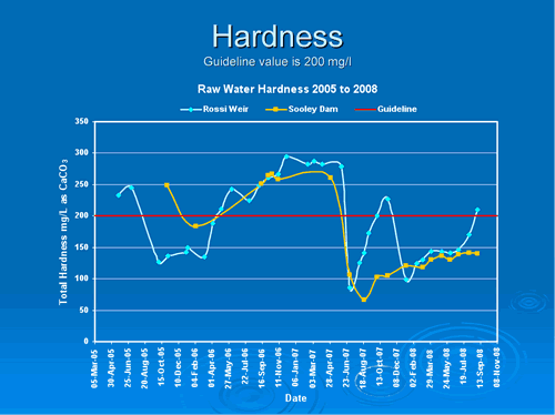
The local catchment promotes hardness in all streams and this has been higher during the drought. Heavy rain in June 2007 reduced hardness but it has since risen as shown in Figure 1. Rossi Weir is on the Wollondilly River above Goulburn.
Figure 1. Raw water hardness in Goulburn Mulwaree Council area
With little water available for irrigation, there is the potential for substantial economic impacts. Irrigators who grow annual crops generally adjust their planting area depending on water availability. However, irrigators who grow perennial crops are impacted in the long term if they are unable to ensure crop survival.
Over the current reporting period, water allocations that were assigned in July 2006 had to be suspended in October and November 2006, due to the drought that resulted in inflows being below previous recorded low inflows. Domestic water restrictions are currently in the majority towns within the catchment. These are used to raise awareness and understanding of the current drought and encourage people to conserve and use water more efficiently, resulting in lower water consumption.
Where are the ‘Hot-Spots’?
The vast majority of the land in Goulburn Mulwaree Council area is used for rural purposes. Land use change has accelerated over the last two reporting periods with many new approvals for additional residential developments and industrial developments occurring. These developments have taken place on land that has long been earmarked for such development and hence these applications have not resulted in the loss of open space. Over the current reporting period, agriculture land use decreased and conservation areas increased.
Treated effluent is disposed of through irrigation onto Council owned land, soccer fields and the Goulburn Racetrack.
The stormwater discharged is not monitored however gross pollutant traps are installed to prevent solid wastes entering the river. A larger discharge during wet weather provided substantial dilution.
Southern Rivers Catchment Management Authority identify some of the key challenges facing catchments in the Goulburn-Mulwaree region as:
- conserving, rehabilitating and sustaining aquatic and terrestrial biodiversity,
- protecting the soil,
- maintaining sustainable production and development,
- developing healthy urban environments,
- recognising and protecting cultural heritage, and
- maximising community participation in catchment health (Southern Rivers CMA, 2008).
What has been done to address Catchment Quality?
The Council is in the process of reviewing its Environmental Protection Zoning as part of the Goulburn Mulwaree Local Environmental Plan. This document is currently being developed.
Land quality issues within rural areas have been a focus for Goulburn Mulwaree Council over the reporting period, with issues relating to noxious weed identification and removal, fertiliser spreading and intensive agriculture requiring Council’s attention. Goulburn Mulwaree Council is addressing rural land use conflicts as part of the Local Environmental Plan and associated Strategy Plan by consulting with the community about techniques to avoid such conflicts.
Treated effluent from the sewage treatment plant is discharged to Council owned land in a sustainable manner to prevent build up of nutrients in the soil. Water quality in adjacent water courses are regularly monitored, ensuring environmental compliance. Over the reporting period, further enhancements were made to the effluent transport and irrigation systems, allowing Goulburn Mulwaree Council to sustainably irrigate an increased annual volume of effluent. Improvements will also be undertaken on the wastewater treatment plant to handle more extreme storm events, with a reduced risk of bypass and potential adverse environmental impacts.
Goulburn Mulwaree Council relaxed water restrictions from Level 5 to Level 3 over the reporting period. Demands remained low and this continues to reduce impacts on the river
Further to this, Goulburn Mulwaree Council continued the education campaign regarding how to achieve low water consumption rates over the reporting period. Households were requested to reduce their water consumption by limiting water use within the home to essential uses only and using water saving devices where possible. Outdoor water use was limited to one hour of hand-held watering in towns. Business and industrial water uses are still restricted but may apply for an exemption to restrictions for specific purposes including enhancing health and education.
Goulburn Mulwaree Council also has a rebate scheme in operation to help manage low water consumption. Rebates apply to 4 Star rated washing machines, 3 Star showerheads and 3 Star dual flush toilet. Council actively encourages the installation of rainwater tanks to existing homes utilizing the NSW Government rebate scheme. In addition to BASIX regulations a 10,000 litre rainwater tank is a mandatory condition for all new homes constructed within Goulburn.
Over the reporting period, Goulburn Mulwaree Council was successful in attracting $40m in funding from the NSW and Commonwealth Governments for drought-proofing Goulburn. The Highlands Source Project was adopted and is to be completed in 2010. One of the benefits of importing water is that appropriate environmental flows can be released to the upper Wollondilly River.
What does this mean for Council?
The catchment data supplied from Council and the Department of Water and Energy is lacking for many indicators. This means that only partial assessment of the catchment quality is possible.
There is limited Council monitoring of erosion, sedimentation, salinity and ground and surface water quality. Therefore, impacts from urban and rural development and significant natural pressures such as drought cannot be fully determined. The monitoring of the implemented Council strategies and associated actions is also necessary to determine their effectiveness in achieving the desired catchment management outcomes.
Goulburn Mulwaree Council should undertake the following actions to ensure environmental improvement in the catchment:
- continue to work closely with Southern Rivers and Hawksbury-Nepean Catchment Management Authorities, to implement joint projects and ensure consistency in approach to land and water management and complementary actions.
- continue and build on the effective relationship NSW State Government agencies to ensure up to date information regarding condition of the catchments environmental drivers such as salinity, and associated management issues relevant to them.
- monitor and adapt to the impacts of climate change to ensure no significant detrimental catchment effect is sustained from the changing conditions and any future actions.
- continue to ensure impacts on ground and surface water quality are considered in landuse zoning, development applications, sewage and water supply treatment.
- implement appropriate environmental monitoring programs to measure the effectiveness of Council's policies, strategies, and management activities.
- support and encourage sustainable land use and water management in the urban and rural communities. Approach business and industries regarding sustainable practices and monitoring.
References
Southern Rivers CMA (2008) Southern Rivers Catchment Management Authority, viewed at http://www.southern.cma.nsw.gov.au/index.html on 14 October 2008.