Goulburn Mulwaree
Indicator: Water Use
Results for this indicator are also available for [an error occurred while processing this directive]
Please note: Text or data highlighted in this colour represent an update to this indicator for the period 2008/09.
What the results tell us about Goulburn Mulwaree
The last time in which the Goulburn water supply dams were full was November 1999 and since that time they dropped to their lowest level of 16.8% in May 2007. Only 182 mm of rain in June 2007 prevented the dire situation continuing. Severe Level 5 restrictions on water use were put into place in 2004 and continued until July 2007. These resulted in a reduction in water use of 54% compared to water use in 1999-2000. It is apparent that urgent action is needed to supplement the Goulburn water supply on a permanent basis, particularly in the light of predicted declines in rainfall in South Eastern Australia resulting from climate change.
Supply- how much water could we have?
The two dams and weir on the Wollondilly River supply water to the drinking water treatment works, for reticulation into the town. The treatment works has full treatment facilities, with capacity to use powdered activated carbon and potassium permanganate for further purification. The microbiological quality of the water distributed is excellent, despite the variable raw water quality and quantity.
Table 1 below shows the capacity of the water storages. The total capacity when full is 13,441 ML., to supply a population of approximately 23,000 people and significant industrial and commercial use.
| Sources of reticulated water (dams, rivers, weirs, bores, etc) | Reticulated water supply for (town/village) | Capacity of dams ML |
|---|---|---|
| Sooley Dam | Goulburn | 6100 |
| Pejar Dam | Goulburn | 9000 |
| Rossi Weir | Goulburn | 300 |
| Wollondilly River | Marulan | Not applicable |
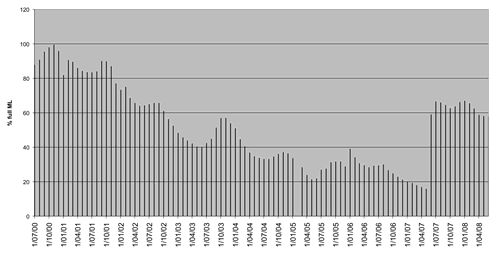
The southern tablelands area of NSW had extensive drought from 2001 which had a direct impact on storage volumes. Figure 1 below shows the combined percentage fullness of the Goulburn water storages from July 2000 at monthly intervals until June 2008. The lowest level reached was in May 2007 with only 16.8 percent of capacity. This represents 2,260 ML of water, or one year of use under severe restrictions, or 6 months supply under normal conditions. In practice the raw water quality deteriorates to the extent that it cannot be processed as dam levels fall towards empty, so the above estimates of the supply are over optimistic.
Heavy rain of 182 mm in June 2007 resulted in recovery of dam levels to 66% in July and August, with only a slow drop to 58% by June 2008. The predicted drop in rainfall over South Eastern Australia resulting from climate change indicates the extreme vulnerability of the Goulburn water supply in the future.
Figure 1. Percentage of fullness of supply dams from July 2000 to June 2008
Consumption – how much water was used?
Total Use
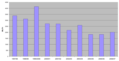
From a peak use of over 4,000 ML in 1999-2000 water consumption has fallen to 1830 ML in 2005-2006. This is a 54% reduction in 5 years.
Figure 2. Total volume of reticulated water used per year.
Use by sector
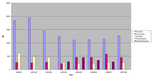
Figure 3 below shows water use by sector, indicating which components of total water use have been reduced to make up the overall water savings at Goulburn. Residential use was lowest in 2004 to 2006, with a small rise in 2007-2008. Commercial water use rose during the drought, from 267 ML/Yr in 2000-2001 to 584 in 2006-2007. Over the same period industrial use fell from 612 to 263 ML/Yr. The operation of the new gaol required 300 to 450 ML/Yr.
Figure 3. Water use by sector in Goulburn Mulwaree Council
Environmental flows
There is no information on environmental flows, though it can be expected that flow in the Wollondilly River below Goulburn would have been minimal as the discharge from the wastewater treatment plant was totally used for irrigation.
Managing water use and demand
Water conservation
Water restrictions commenced in 2002-2003 and progressively increased in severity up to Level 5 for 273 days in 2004-2005, and all year in 2005-2006 and 2006-2007. Since July 2007 restrictions have been relaxed to Level 3. Consumption trends indicate that demands did not immediately increase after the change from level 5 (Target 5/ml/DAY) to level 3 (Target 7.8 ML/day) restrictions on 6 July 2007. During 2008-09 the level three restriction target of 7.8ML/day was exceeded on 41 days. Often the excess was only minimal and, as would be expected, occurred in the period of hottest weather between December 2008 and March 2009. Conversely, water use was well below target (often almost half) for the remainder of the period. Table 4 presents water consumption in Goulburn Mulwaree Shire for the period 2008-09. Table 5 presents comparison data for the 'pre-drought' period 200-01.
Figure 4. Goulburn water consumption June 2008 to June 2009
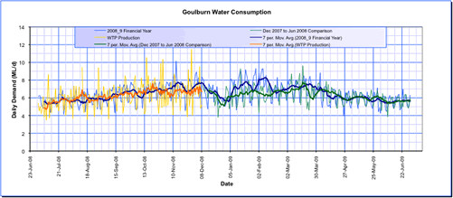
Source: Goulburn Mulwaree Shire Council
Figure 4 was updated to include data for 2008/09.
Figure 5. Goulburn water consumption comparison to June 2000 to June 2001 'pre-drought'
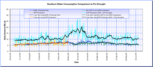
Source: Goulburn Mulwaree Shire Council
Figure 5 was updated to include data for 2008/09.
The regulations applying to water restrictions in Goulburn are set out on the web site below, together with the trigger levels at which the restrictions come into force.
http://goulburn.local-e.nsw.gov.au/files/3778/File/PolicyonWaterRestrictions20.12.05.pdf
Water restrictions applied in Marulan village since 2002, and limit reticulated water use to within the home, and the watering of lawns and gardens by hand within fixed hours. Fixed irrigation systems are banned from use.
All treated wastewater from Goulburn and Marulan treatment plants was used for irrigation.
Laws and policy
Goulburn Mulwaree Council is currently in the process of developing a Water Management Strategy to provide a long term sustainable solution to water issues in the Local Government Area (LGA).
The strategy will be developed in partnership with the community, key stakeholders and a range of government agencies, so that potential management options reflect the needs and concerns of these groups.
Future water supply.
The outcome of the policy development will guide the resolution of the ongoing water shortage in Goulburn. It is clear that additional supply is required from another river system, either by dam and pipeline or by pumping, from a more reliable river.
About the data
Quantitative data were received from the Goulburn Mulwaree Council.