Eurobodalla
Please note: Text or data highlighted in this colour represent an update to this indicator for the period 2008/09. All temperature figures have been updated on this page. Evaporation and Soil Moisture have also been included in this update.
Temperature Analysis
Moruya Heads Pilot Station (Bureau of Meteorology Station No. 069018) commenced operation in 1876 and has a continuous set of high quality temperature observations since 1910. It is a Bureau of Meteorology Climate Reference Station.
Note that in the following analyses temperatures for individual months are compared to the long-term average (or climatology) from 1975-2004. A 30-year period is used to calculate climatological averages to conform with World Meteorological Organisation practice; this takes into account year-to-year variations and less frequent events such as El Niño or La Niña. This particular 30-year period is used in this analysis because it is the period with the best temperature data availability across the Australian Capital Region.
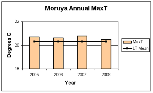
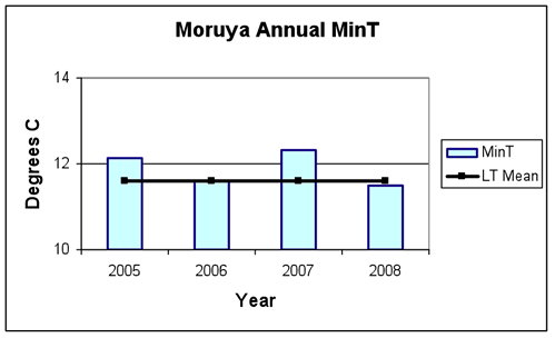
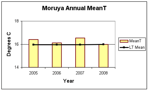
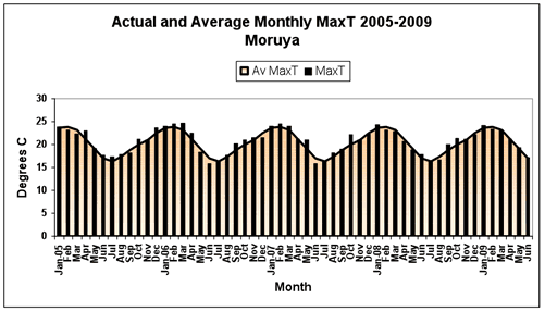
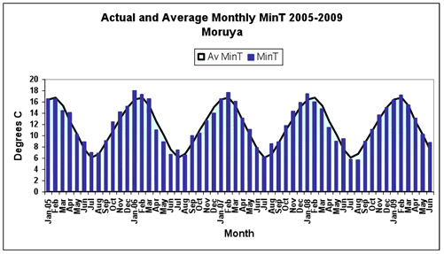
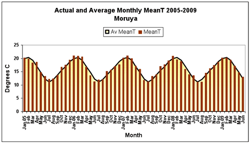
The annual averages of both maximum and minimum temperatures for the period 2005-2008 (Table 1 and Figure 1) were around or above the long-term mean. The daily maximum temperature is usually measured in the early afternoon, while the minimum temperature is usually recorded just before sunrise. Overall mean daily temperatures, calculated as the average of the maximum and minimum temperature each day, were thus also average or above average in all four years.
2005 |
2006 |
2007 |
2008 |
|
|---|---|---|---|---|
| Mean Daily Maximum Temperature | 20.7 |
20.6 |
20.8 |
20.5 |
| Anomaly (oC) | 0.4 |
0.3 |
0.5 |
0.2 |
| Anomaly (%) | 2% |
2% |
2% |
2% |
| Mean (1975-2004) | 20.3 |
|||
| Mean Daily Minimum Temperature | 12.1 |
11.6 |
12.3 |
11.5 |
| Anomaly (oC) | 0.5 |
0.0 |
0.7 |
-0.1 |
| Anomaly (%) | 4% |
0% |
6% |
-1% |
| Mean (1975-2004) | 11.6 |
|||
| Mean Daily Mean Temperature | 16.4 |
16.1 |
16.5 |
16.0 |
| Anomaly (oC) | 0.5 |
0.2 |
0.6 |
0 |
| Anomaly (%) | 3% |
1% |
4% |
0% |
| Mean (1975-2004) | 16.0 |
|||
|
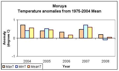
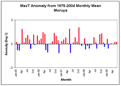
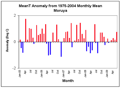
In the 54-month period January 2005- June 2009 there were 34 months (63%) in which the monthly maximum temperatures were above the long-term average (Figure 2). This four year period had generally warmer monthly average daytime temperatures than the long-term mean. Maximum temperature anomalies were highest in October 2007 (2.1oC above the monthly average), whereas in December 2006 the average daily maximum temperature was 1.2oC below the monthly average.
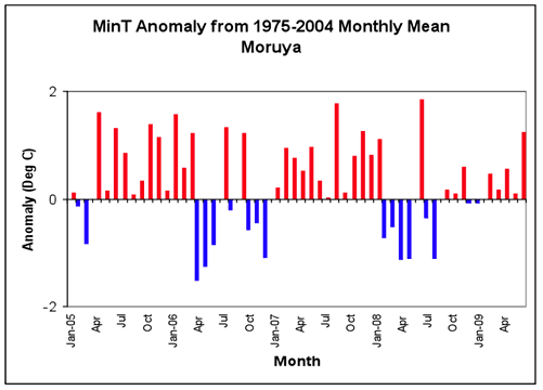
For minimum temperatures, there were also 34 months (63%) with temperatures above the long-term average (Figure 2), particularly between April 2005 and March 2006, and from January 2007-January 2008. Minimum temperature anomalies were highest in June 2008 (1.9oC above the monthly average), whereas in April 2006 the average daily minimum temperature was 1.5oC below the monthly mean.
Overall, the daily mean temperatures show a warm period in both maximum and minimum temperatures with sixteen months below the long term average. The longest period of cooler than average conditions was January -March 2008. Note that an El Niño event occurred in 2006/2007; temperatures tend to be above average during these events, particularly during spring and summer.
|
Long Term Climate Trend
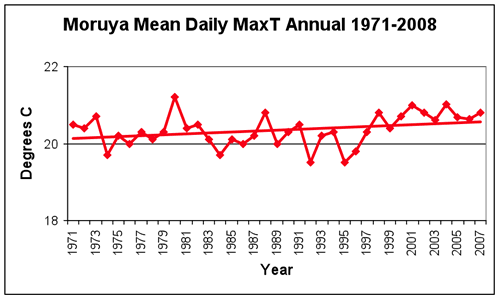
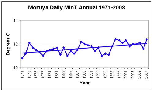
It is useful to compare recent climate observations with a longer record in order to assess how unusual recent events may be. Both maximum and minimum temperatures at Moruya have increased since 1971 (Figure 3). In particular, this increasing trend is quite evident over the last ten years for maximum temperatures, while minimum temperatures have remained relatively steady over this same period at levels above the average.
|
Evaporation and Soil Moisture
Evaporation and soil moisture are important components of the moisture balance in the environment. Potential evaporation (the amount of moisture evaporated from an open water surface under prevailing conditions) occurs as a consequence of a combination of factors including incoming solar radiation, temperature, wind and the humidity of the air. The balance among the factors controls the amount of potential evaporation, so that an increase in solar radiation or temperature (which would cause evaporation to increase if all other factors remained unchanged) might be offset by a decrease in wind (which would cause evaporation to decrease). Soil moisture reflects the interaction between rainfall and evaporation, and provides an indication of the amount of moisture available for plant growth.
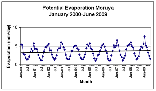
The variation in potential evaporation at Moruya for the period 2000-2008 is illustrated in Figure 4. There is strong seasonal variation between summer and winter, with low values in winter and high values in summer. Potential evaporation over this period shows little overall trend or change from year to year, except during the 2008-9 summer when potential evaporation increased.
|
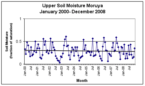
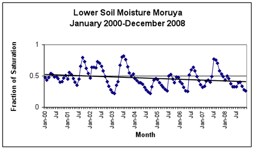
Soil moisture variations at Moruya in the upper and lower layers in the period 2000-2008 are illustrated in Figure 5. The impact of rainfall on the upper level soil moisture profile is evident in the relatively large and rapid fluctuations within the time period, which closely mirror the variability of rainfall at Moruya. The lower level soil moisture shows the effects of recurrent dry periods since 2000; there is a slight overall decline in the lower soil moisture, with any increases in moisture being relatively abrupt (following larger rainfall events) followed by longer periods of drying. The overall downward trend in lower-level soil moisture at Moruya is smaller than it is at inland locations in the region. The time lag in changes to the lower level soil moisture following rain events is also evident.
|
About the data
Evaporation and soil moisture data were extracted from the Australian Water Availability Project (AWAP) dataset, a jointly funded project developed by CSIRO Marine and Atmospheric Research (CMAR), the Bureau of Meteorology (BoM) and the Bureau of Rural Science (BRS) to monitor the terrestrial water balance of Australia. Upper level soil depth is considered to be to a depth of 0.2m while lower level soil depth is considered to be to between 0.2m and 1.5 m.
References
M.R. Raupach, P.R. Briggs, V. Haverd, E.A. King, M. Paget and C.M. Trudinger, 2009 Australian Water Availability Project (AWAP): CSIRO Marine and Atmospheric Research Component: Final Report for Phase 3. CAWCR Technical Report No. 013. 67 pp.