Cootamundra
Indicator: Land Use
Results for this indicator are also available for [an error occurred while processing this directive]
What the results tell us for Cootamundra
Maps of land use in | 1997 | 2000 | 2004 | 2008 (see below)
At the time of reporting, there was no current landuse data available for Cootamundra Shire for the 2008 reporting period. As such, it is unknown whether there have been any major landuse changes in the Shire since 2004.
In 2004, the main landuse in Cootamundra Shire was agriculture, which made up 93% of the total Shire area. Conservation was the next most significant landuse within the Shire, comprising some 3% of the total Shire area.
How is the land being used now?
As reported in 2004, of the total Council area (152,360 hectares), the dominant landuse at the end of the previous reporting period was agriculture (93%) (see Figure 1). The township of Cootamundra and the villages of Wallendbeen and Stockinbingal, which cover 2% of the total Shire area, comprised the majority of urban land.
Figure 1. Major landuse in Cootamundra Shire, June 2004
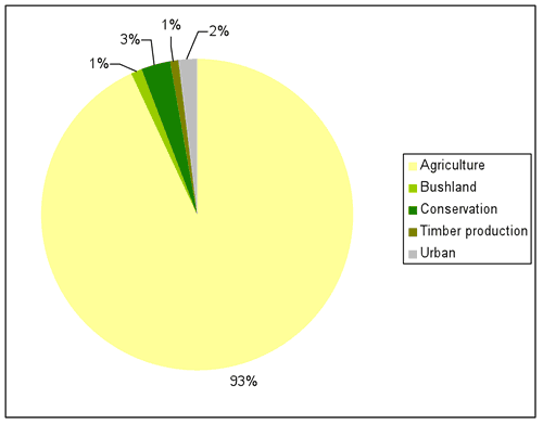
Source: Cootamundra State of the Environment Report 2004
What has changed and why?
In the previous reporting period, that no major broadscale changes in landuse within the Shire between 1997 and 2004 (see Table 1). With no available landuse data for the current reporting period, it is unknown whether there have been major landuse changes since the 2004 report.
| Landuse Category | 1997 | 2000 | 2004 |
|---|---|---|---|
| Agriculture | 93% | 93% | 93% |
| Bushland | 1% | 1% | 1% |
| Conservation | 3% | 3% | 3% |
| Quarries | -% | -% | -% |
| Timber production | 0.8% | 0.8% | 0.8% |
| Urban | 2% | 2% | 2% |
| Waterbodies | 0.04% | 0.04% | -% |
Source: Cootamundra State of the Environment Report 2004
Agriculture
No current agriculture landuse data was available for Cootamundra Shire for the 2008 reporting period.
The total amount of land under agricultural production in the Shire has remained relatively stable since 1997 (see Table 1). In 2004, despite the 2002–03 drought being the third driest year since 1882, there appears to have been a shift from grazing and mixed farming to cropping. Mixed farming in the Shire appears to have decreased since 1997, while the areas under cropping and grazing have fluctuated. In 2004, the Shire had considerable crop growing and sheep grazing, with some cattle grazing, and was experiencing a shift away from sheep grazing to wheat growing in the last decade (Schirmer et al. 2005).
Timber production
No current timber landuse data was available for Cootamundra Shire for the 2008 reporting period.
In 2004, the area of State owned timber production forest remained stable during the previous reporting period. No softwood plantations occur on private lands within the Shire.
Bushland
No current landuse data relating to bushland was available for Cootamundra Shire for the current reporting period.
The area of bushland in the Shire categorised as bushland has remained relatively stable since 1997 (see Table 1).
Conservation
No current landuse data relating to conservation was available for Cootamundra Shire for the current reporting period.
In 2004, no new conservation reserves or additions to existing conservation reserves within the Shire have occurred since 1982. Although two wildlife refuges are located within the Shire, they were mapped mostly as agricultural landuses.
Future planning
As part of its 2006-07 Annual Report, Council has prepared an Environmental Action Plan to facilitate environmentally sustainable development and to ensure the ongoing protection of the environment. The plan has also updated the existing planning controls for the Cootamundra Shire area.
About the data
The landuse maps and statistics reported in this section are based on data from NSW State Government agencies, Council and statellite images. The primary purpose of the mapping was to assess trends in landuse change and not to provide an accurate account of the actual areas changed.
Cootamundra Shire Council provided Draft Local Environmental Plan data. In general the data provided by Council and State Government departments showed a higher level of detail than satellite classifications. Therefore, these layers were usually used as the primary source of data and supplemented by satellite imagery (Landsat data and SPOT VI data) as needed (mostly for agricultural landuses and bushland). Agricultural subcategories were not used in the final maps, and all agricultural land was classified as 'agricultural—general'. However, general statements regarding trends in agricultural subclasses were derived from mapped data.
All landuse maps for Cootamundra Shire were provided to Council for checking and correction, particularly for 2004 and 2000.
All percentages shown in this indicator are a percentage of the Shire and not a percentage of the landuse type. The areal extents of the various landuse types (hectares) were calculated from data that had been adjusted (normalised) to take account of (usually minor) differences between the size of Cootamundra Shire as gazetted by Council, and the size calculated from spatial data.
References
Schirmer, J, Parsons, M, Charalambou, C and Gavran, M (2005) Socio-economic Impacts of Plantation Forestry in the South West Slopes of NSW, 1991 to 2004, report produced for Forest and Wood Products Research and Development Corporation, project no PN04.4007, Bureau of Rural Sciences, Canberra.
