Boorowa
Indicator: Surface Water Quality
Results for this indicator are also available for [an error occurred while processing this directive]
What the results tell us for Boorowa
Boorowa Council area features Boorowa River, Hovells Creek and the Lachlan River that forms the eastern boundary. It is located in the upper catchment of the Lachlan River. The Council area has a diverse network of surface drainage leading to the main river systems. Water from these river systems also sustains much of Boorowa’s irrigated agriculture.
The Boorowa River flow rate varies from less than 1 ML/day to over 10,000 ML/day in peak flow conditions. The Boorowa River’s catchment is divided into eight local sub-catchments that flow into the river, these are Breakfast Creek, Castle Creek, Gunnary Creek, Kangiara Creek, Langs Creek, Narallen Creek, Pudman Creek and Yellow Waterhole.
Three key determinants of surface water quality, electrical conductivity, total phosphorus and turbidity levels. There are two monitoring sites in Boorowa. However the only results for electrical conductivity were available over the reporting period.
Trends in surface water quality
Surface water quality monitoring is undertaken at:
- Boorowa River at Prossers Crossing (site number 412029), and
- Lachlan River at Wyangala (site number 412067).
| Parameter* and location | Median values | Default trigger values ** | ||
|---|---|---|---|---|
| 1997–2000 | 2000–04 | 2004-08 | ||
| Boorowa River at Prossers Crossing (412029) | ||||
| Electrical conductivity (µS/cm) | 929 | 928 | 811 | 350 |
| Total phosphorus (µg/L) | 35 | 39 | - | 20 |
| Turbidity (NTU) | 5 | 7 | - | 25 |
| Lachlan River at Wyangala (412067) | ||||
| Electrical conductivity (µS/cm) | 339 | 350 | ||
| Total phosphorus (µg/L) | - | 20 | ||
| Turbidity (NTU) | - | 25 | ||
* µS/cm = microsiemens per centimetre; µg/L = microgram per litre; NTU = nephelometric turbidity unit; ** For information on default trigger values, see About the Data
Source: NSW Provisional River Data, 2008
Figure 1. Electrical Conductivity for Boorowa River at Prossers Crossing, 2004-08
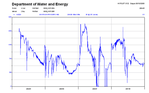
Source: NSW Provisional River Data, 2008
Figure 2. Electrical Conductivity for Lachlan River at Wyangala, 2004-08
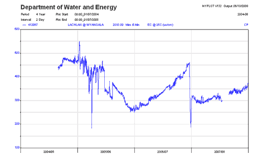
Source: NSW Provisional River Data, 2008
Boorowa River at Prossers Crossing
During the reporting period, the median value for electrical conductivity at Prossers Crossing was more than double the default trigger value(Table 1). This trend is consistent with the previous two reporting periods between 1997 to 2000 and 2000 to 2004. Figure 1 shows large variations in the electrical conductivity over the reporting period.
Turbidity exceedence is rated as poor at this site but the total phosphorus exceedance is rated as good (Australian Natural Resources Atlas).
Lachlan River at Numby
Water quality samples at the Lachlan River at Numby (412088) have not been sampled since 2002. Total phosphorous exceedance was rated as fair for the reporting period (Australian Natural Resources Atlas). The salinity exceedance was good, and the turbidity exceedance as poor (Australian Natural Resources Atlas).
Lachlan River at Wyangala
During the reporting period, at Wyangala the median value for electrical conductivity was slightly under the default trigger value. No trends are able to be reported monitoring site, as it has not been previously reported. The monitoring site appears to have been installed in 2001. However over the current reporting period, there were small fluctuations in electrical conductivity (Figure 2).
Other studies
Two Waterwatch sites exist in the Council, at Kiamma Creek and the school dam which flows into Narrallen Creek.
About the data
Data for the monitoring sites covered in this report were from the NSW Department of Water and Energy (DWE) http://www.dwe.nsw.gov.au/
Data is routinely reported at http://nratlas.nsw.gov.au. DWE is responsible for quality control and on-going maintenance of the data collected in its databases.
Interpreting the data
Default environmental value
The Water Quality and River Flow Interim Environmental Objectives (EPA 1999) for NSW, which are still current, indicate that protection of aquatic ecosystems is the default environmental value for most water bodies in catchments associated with Boorowa Council area. Although individual councils are free to assign additional or different value through local processes and based on site-specific information, so far no councils in the Australian Capital Region have done so.
Default trigger values
The default trigger values used in this report were those values set out in Australian and New Zealand Environment and Conservation Council (ANZECC) and Agriculture and Resource Management Council of Australia and New Zealand (ARMCANZ) (2001). The values applicable to the Australian Capital Region are those for "south-east Australia for slightly disturbed ecosystems" (ANZECC and ARMCANZ 2001). The default trigger values for different water quality parameters for the protection of aquatic ecosystems are based on the type of water body in question. Compared to most other environmental objectives, the protection of aquatic ecosystems is one that requires more stringent water quality guidelines.
The median value (i.e. middle value of a data series) for each monitoring site in the Council area over the reporting period was compared with the default trigger value from the guideline values suggested in ANZECC and ARMCANZ (2001). This approach was recommended when no environmental values were set, water quality objectives were not determined, local reference sites were unavailable and local site-specific information could not be sourced. This broad reporting approach cannot be used to assess 'compliance'; it is merely a warning system to alert natural resource managers.
The data was firstly sourced from the NSW Natural Resource Atlas, if the relevant data wasn’t available from this resource, the information supplied from the NSW Department of Water and Energy (DEW) was used. The data from the NSW Natural Resource Atlas generally provided daily data on stream flow and electrical conductivity, amongst others. Whereas the data supplied by the DEW had periodic samples of the data, however did include values for the turbidity and total phosphorus.
Electrical conductivity is a measure of the ability of water to conduct an electric current. This is considered an appropriate indicator of salinity, as it is proportional to the concentration of total dissolved salts in water.
Phosphorus is considered as a key indicator of eutrophication in Australian freshwaters because it is typically a limiting nutrient for primary production under natural conditions (Cullen 1986; Donnelly et al. 1992). Total phosphorus is analysed as it represents an aggregation of all fractions of phosphorus reaching the water column from various processes and it represents the potential maximum concentration of phosphorus available for biological uptake (NSW EPA 2000).
Australia has naturally turbid waters, owing to deeply weathered soils rich in clay-sized particles. These particles are readily transported to streams during storms. Because of their colloidal nature they remain suspended in the water column, resulting in high turbidity (Cullen 1986). In addition to natural causes, the turbidity of many waters has increased as a result of human-induced erosion through practices such as land clearing (agriculture and forestry), urbanisation, extractive industries and river regulation (Walker 1985). Turbidity is a measure of light scattering and absorptive properties of water, which are roughly proportional to the type and concentration of suspended matter. It is therefore commonly used as an indicator of the amount of suspended matter in the water column, although quantitative relationships between the two are difficult to define, because various types of suspended material have different light-scattering properties.
Additional data
Other potential sources of water quality monitoring data include the Community Access to Natural Resources Information (CANRI) website and the Waterwatch program.
References
ANZECC – see Australian and New Zealand Environment and Conservation Council
ARMCANZ – see Agriculture and Resource Management Council of Australia and New Zealand
Australian and New Zealand Water Environment and Conservation Council (ANZECC) (1992) Australian Water Quality Guidelines for Fresh and Marine Waters, Prepared for the National Water Quality Management Strategy
Australian and New Zealand Environment and Conservation Council and Agricultural and Resource Management Council of Australia and New Zealand (ARMCANZ) (2001) Australian Water Quality Guidelines for Fresh and Marine Waters, Prepared for the National Water Quality Management Strategy
Australian Government (2008), Australian Natural Resources Atlas, viewed at http://www.anra.gov.au/index.html on 7 October 2008
Cullen, P. 1986, ‘Managing nutrients in aquatic ecosystems: the eutrophication problem’, in Deckker P. and Williams W.D. (eds) Limnology in Australia, CSIRO, Melbourne, pp.539–554.
Donnelly, T.H., Caitcheon, G.G. and Wasson, R.J. 1992, ‘Algal blooms in inland Australian water systems: sourcing nutrients and turbidity’, in CSIRO Division of Water Resources Divisional Report 92/4, CSIRO, Canberra, pp.74–81
NSW EPA (2000) NSW 2000 State of the Environment Report – Waters Chapter
NSW NRA (2008), New South Wales Natural Resource Atlas: NSW Provisional River Data, viewed at http://nratlas.nsw.gov.au on 7 October 2008
Walker, K.F. 1985, ‘A review of the ecological effects of river regulation in Australia’, Hydrobiologia vol.125, pp.111–129
Waterwatch NSE (2006), Waterwatch NSW, view at http://www.waterwatch.nsw.gov.au/index.html on 7 October 2008
