Boorowa
Indicator: Land Use
Results for this indicator are also available for [an error occurred while processing this directive]
What the results tell us for Boorowa
Maps of land use in | 1997 | 2000 | 2004 | 2008 (see below)
The Boorowa Council area covers an area of 2,579 km2. Boorowa Council area is known to be one of the best fine wool sheep growing areas in Australia. It is also the main natural breeding habitats for the threatened species, the Superb Parrot.
Key industries in Boorowa Council area include fine merino sheep wool production, horse breeding and cattle studs. The temperate climate, rich soils and reliable rainfall also make the region ideal for agricultural production, such as wheat and canola.
How is the land being used now?
The majority of agricultural land in the Council area is used for grazing. Figure 1 shows most rural land use is classified as either grazing natural vegetation or grazing modified pastures. Livestock grazing generally applies to grazing on native pasture and grazing of modified/sown pastures, cropping and horticulture, is where no irrigation is used.
Figure 1. Landuse, Boorowa Council Area, 2001
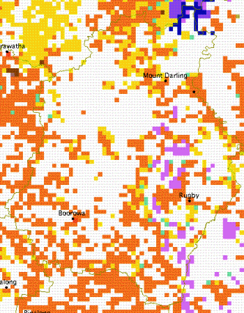
Source: Australian Natural Resources Atlas, 2008
Agriculture
Agriculture is the major industry within Boorowa Council area with prominent activities including sheep and wool production, grain and oil seed growing, beef cattle, and piggeries.
Conservation
Boorowa Council area does not contain any large reserves of Crown Land with the majority of land being within private ownership. In the past, extensive clearing of an estimated 85% of the native vegetation within Boorowa Council are for farming has had a substantial impact, whereby almost all of the native vegetation communities have been cleared or substantially modified (Habitat Planning, 2006).
What has changed and why?
No figures were provided from the Council on changes to landuse over the current reporting period. However, it is possible that no broadscale change in landuse was expected, as there has been no significant landuse change over the previous three Regional State of the Environment reporting periods.
Future planning
The current local environmental planning instrument being administered by Boorowa Council is Interim Development Order No. 1 – Shire of Boorowa. The document is ‘deemed’ to be a Local Environmental Plan for the purposes of the Environmental Planning and Assessment Act 1979.
The Interim Development Order is relatively simple and provides for just three land use zones – Village or Township, Non-urban ‘A’ and Non-urban ‘B’. Development controls are expressed in the document relate to building setbacks, amenity impacts, traffic, parking, access, flooding, subdivision, rural dwellings, advertising signs, exemptions for public works and tree preservation order. The document was first advertised in April 1975, however, it has been amended twice since.
Boorowa Council has started to prepare a new planning instrument to replace the existing Interim Development Order. The new planning instrument is to include a Strategic Land Use Plan (currently in draft form) and Local Environmental Plan in accordance with the State Government’s Planning Reform Program. The recommendations of the Strategic Land Use Plan will form the basis of the new Local Environmental Plan for Boorowa.
About the data
All percentages shown in this indicator are a percentage of the Council area and not a percentage of the landuse type.
References
Australian Natural Resources Atlas (2008) Australian Natural Resources Map, Landuse 2001, Australian Government, viewed at http://www.anra.gov.au/mapmaker/mapservlet?app=anra on 1 October 2008.
Habitat Planning (2006) Boorowa Council New Planning Instrument–Draft for Public Exhibition, Habitat Planning, Albury-Wodonga, viewed at http://www.boorowa.nsw.gov.au/files/1436/File/DRAFTSTRATEGICLANDUSEPLAN.pdf on 1 October 2008.
Office of the Commissioner for the Environment (1997) Australian Capital Region State of the Environment Report 1997, Office of the Commissioner for the Environment, Canberra.
Office of the Commissioner for the Environment (2000) Australian Capital Region State of the Environment Report 2000, Office of the Commissioner for the Environment, Canberra.
Office of the Commissioner for the Environment (2005) Australian Capital Region State of the Environment Report 2004, Office of the Commissioner for the Environment, Canberra.
