Yass Valley
Indicator: Land Use
Results for this indicator are also available for [an error occurred while processing this directive]
What the results tell us for Yass Valley
Maps of land use in | 1997 | 2000 | 2004 | 2008 (see below)
Landuse in the Yass Valley Council area is similar to that for the previous reporting period. In 2008, the main landuse in Yass Valley Council area continues to be agriculture, which made up 73% of the total Council area. Bushland and conservation were the other major landuses, comprising some 16% and 8% of the Council area respectively.
How is the land being used now?
Of the total Council area (398,511 hectares), the dominant landuses at the end of the current reporting period continued to be agriculture (73%) and bushland (16%) (see Figure 1). Yass township, which comprised approximately 1% of the total Council area, comprised the majority of urban land.
Figure 1. Major landuse in Yass Valley Council area, June 2008
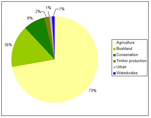
Source: Yass Valley Council
What has changed and why?
Landuse within the Yass Valley Council area has remained relatively stable since 1997, with no major changes in landuse occurring in the current reporting period (see Table 1). Minor changes that have occurred since 2000 included a decrease in land classified under bushland and a close corresponding increase in the land categorised as conservation.
| Landuse Category | 1997 | 2000 | 2004 | 2008 |
|---|---|---|---|---|
| Agriculture | 72% | 72% | 72% | 73% |
| Bushland | 19% | 19% | 17% | 16% |
| Conservation | 4% | 4% | 6% | 7% |
| Quaries | 0.03% | 0.03% | 0.03% | 0.03% |
| Timber production | 2% | 2% | 2% | 2% |
| Urban | 1% | 1% | 1% | 1% |
| Waterbodies | 2% | 1% | 1% | 1% |
Source: Yass Valley Council
Agriculture
The total amount of land under agricultural production in the Council area remained relatively constant in the current reporting period (see Table 1).
At this stage in the reporting cycle, it is unknown whether there has been a significant change in the use of land under agricultural production. Preliminary land use data provided by Yass Valley Council suggests that the use of land under agricultural production has remained relatively stable in the current reporting period, with estimated grazing (approximately 49% of total Council area) remaining the dominant use of agricultural land.
As noted in 2004, there has been a longer trend shift from grazing to cropping and mixed farming within the Council area. Possible drivers of change in agricultural landuses (Sheppard 2006) include: drought and availability of water; poor returns; adoption of new crops/pastures as well as new technologies/methods, resulting in the intensification and/or conversion of land uses; land degradation; people seeking "lifestyle change"; and increasing pressure for subdivision and rezoning of land from rural to urban.
Timber production
The area of land under timber production within the Council area remained constant in the current reporting period (see Table 1), and has remained stable since 1997.
At this stage in the reporting cycle, it is unknown whether there has been a significant change in the use of land under timber production. However, as reported in 2004, the area of state-owned timber production forests in the Council area decreased over the previous reporting period, while the area of private lands under timber production increased by approximately 90 hectares (predominantly through the conversion of agricultural land to softwood plantations). Overall, there was a net decrease of about 1,800 hectares of land under timber production in the Council area (see Figure 2).
In 2004 State Forest land used for timber production decreased by about 1,400 hectares, due to its rezoning as part of the Southern Regional Forest Agreement (Southern RFA) to Forest Management Zone 2 (informal reserves). Areas of this forest management zone are still managed by Forests New South Wales (NSW) but for the protection of their high or significant conservation values instead of for timber production. The native hardwood forests transferred from timber production to conservation zones may have been selectively logged at some time in the past, but would generally have comprised the least productive forest. For more information about the Southern RFA process, which was part of comprehensive regional assessments undertaken in NSW between 1997 and 2000, see www.racac.nsw.gov.au/overview/cras.shtml.
Figure 2. Timber production landuse subcategories in Yass Valley Council area in 1997, 2000 and 2004*
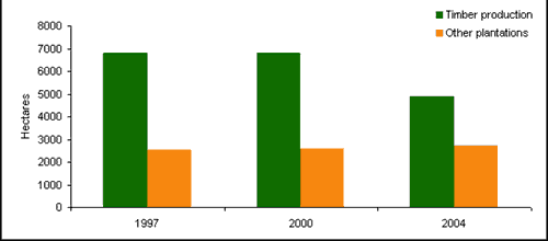
Source: 2004 ACT State of the Environment Report; *timber landuse subcategory information was not available for 2008 at the time of reporting.
Source: see About the data
Bushland
The area of land in the Yass Valley Council area categorised as bushland decreased slightly during the current reporting period, from 17% of the total Council area in 2004 to 16% of the total Council area in 2008.
Conservation
The area of land under conservation in the Council area increased slightly to 7% (approximately 27,600 hectares) of the total Council area in 2008 from 6% of the total Council area in 2004.
Since 2000 there has been an increase in the total area of land under conservation in the Council area. As reported in 2004, this is in part due to land converted from timber production and transferred from other Crown lands under the Southern RFA to help develop a comprehensive, adequate and representative reserve system to protect forest ecosystems and conserve biodiversity. These lands became nature reserves and 'other conservation' areas (see Figure 3). Areas of Crown lands shown as bushland in 2000 and 1997 were also converted to national park, nature reserve and state conservation areas under the Southern RFA. Three new reserves were created within the Council area during the reporting period, i.e. Black Andrew and Oak Creek Nature Reserves and Brindabella State Conservation Area. Additions to existing reserves in 2004 included Brindabella National Park and Burrinjuck Nature Reserve.
Figure 3. Conservation landuse subcategories in Yass Valley Council area in 1997, 2000 and 2004*
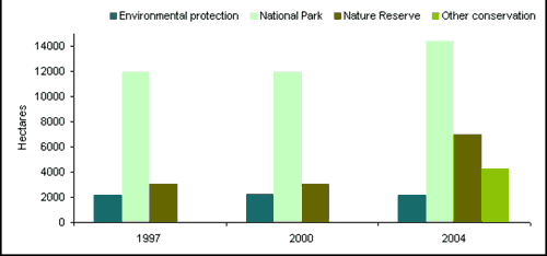
Source: 2004 ACT State of the Environment Report; *conservation landuse subcategory information was not available for 2008 at the time of reporting.
Source: see About the data
Future planning
Following the Local Government boundary changes which occurred during the 2004 reporting period, Yass Valley Council is in the process of reviewing the 1987 Yass Local Environmental Plan (LEP), the 1997 Gunning LEP, and the 2002 Yarrowlumla LEP and is currently undertaking a comprehensive strategic planning work program to prepare a comprehensive LEP to supersede all three of these.
About the data
The landuse maps and statistics reported in this section are based on data from NSW State Government agencies, Council and satellite images. The primary purpose of the mapping was to assess trends in landuse change and not to provide an accurate account of the actual areas changed.
In general the data provided by Council and State Government departments showed a higher level of detail than satellite classifications. Therefore, these layers were usually used as the primary source of data and supplemented by satellite imagery (Landsat data and SPOT VI data) as needed (mostly for agricultural landuses and bushland).
All landuse maps for Yass Valley Local Government area were provided to Council for checking and correction, particularly for 2004 and 2000.
All percentages shown in this indicator are a percentage of the local government area and not a percentage of the landuse type. The area extents of the various landuse types (hectares) were calculated from data that had been adjusted (normalised) to take account of (usually minor) differences between the size of Yass Valley Local Government Area as gazetted by Council and the size calculated from spatial data.