Upper Lachlan
Indicator: Land Use
Results for this indicator are also available for [an error occurred while processing this directive]
Please note: Text or data highlighted in this colour represent an update to this indicator for the period 2008/09.
What the results tell us for Upper Lachlan
Maps of land use in | 1997 | 2000 | 2004 | 2008 (see below)
No landuse data are available for the current reporting period. Information provided is based on data from the previous reporting period. The main landuse in Upper Lachlan Shire in 2004 was agriculture which made up 72% of the total Shire. The other major landuse was bushland, which comprised some 23% of the Shire.
How is the land being used now?
Of the total Shire (708,886 hectares), the dominant landuses in Upper Lachlan Shire in 2004 were agriculture (72%) and bushland (23%) (see Figure 1). The villages of Crookwell, Taralga and Gunning made up the majority of the urban land, which comprised only 0.1% of the total area.
Figure 1. Major landuse in Upper Lachlan Shire, June 2004*
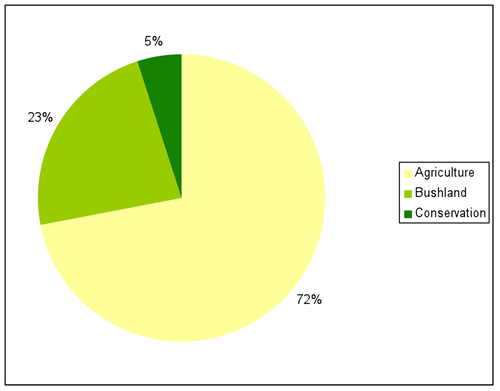
Source: Upper Lachlan Shire Council; *Landuse information for 2008 was not available at time of reporting, some subcategories are too low to appear in the figure
What has changed and why?
No landuse data was available at the time of reporting for the current period. No major broadscale changes in landuse occurred within the Shire between 1997 and 2004 (see Table 1).
| Landuse Category | 1997 | 2000 | 2004 |
|---|---|---|---|
| Agriculture | 71.5% | 71.5% | 71.5% |
| Bushland | 23% | 23% | 23% |
| Conservation | 4.6% | 4.6% | 4.7% |
| Quarries | 0.02% | 0.02% | 0.02% |
| Timber production | 0.4% | 0.4% | 0.3% |
| Urban | 0.1% | 0.1% | 0.1% |
| Waterbodies | 0.5% | 0.5% | 0.5% |
Source: Upper Lachlan Shire Council
Agriculture
As illustrated in Table 1 the total amount of land under agricultural production in the Shire has remained constant since 1997.
At this stage in the reporting cycle, it is unknown whether there has been a significant change in the use of land under agricultural production. As reported in 2004, the areas of cropping and mixed farming land increased by approximately 12,600 hectares and 19,000 hectares respectively, while land used for grazing decreased by a similar amount. It is possible that some of these changes may have been the result of prolonged drought conditions. The 2002–03 drought was the third driest year since 1882.
The shift from grazing to cropping and mixed farming is part of a longer-term trend within the Shire (see Figure 2). During the 2004 reporting period there has been an increase in grazing of animals such as alpacas and a switch from sheep to cattle grazing within the Shire.
Figure 2. Agricultural landuse subcategories in Upper Lachlan Shire in 1997, 200 and 2004*
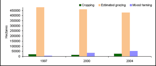
Source: 2004 Regional State of the Environment Report; *Agricultural landuse subcategory information for 2008 was not available at time of reporting.
Timber production
At this stage in the reporting cycle, it is unknown whether there has been a change in the use of land under timber production in 2008. With timber production accounting for only approximately 0.3% of the total Upper Lachlan Shire in 2004, it is unlikely that any change in the use of land under timber production will be substantial.
Bushland
There has been no reported change to the area of bushland in the Shire in the current reporting period.
Conservation
At the time of reporting, no information regarding the area of land under conservation in 2008 was available. In 2004, the area of land in the Shire under conservation increased by approximately 1025 hectares. This was predominantly due to land being converted from timber production under the Southern Regional Forestry Authority (RFA) to help develop a comprehensive, adequate and representative reserve system to protect forest ecosystems and conserve biodiversity. These lands became 'other conservation' areas.
Future planning
Following the Local Government boundary changes which occurred during the 2004 reporting period, Council amalgamated and reviewed the 1997 Gunning Local Environmental Plan (LEP), the 1994 Crookwell LEP and the 1995 Mulwaree LEP to produce a single plan covering the whole Council area. As part of the review, Council is preparing an Upper Lachlan Strategy Plan to include a local environmental study, a new comprehensive LEP and a set of principles for development control. This strategy will provide a framework for development within the Shire until the year 2020 (Upper Lachlan Shire Council 2005).
The new Draft Local Environmental Plan (Upper Lachlan Local Environmental Plan 2008) was placed on Public Exhibition in May 2009 and will guide the future landuse of the Shire.
About the data
At the time of reporting, no landuse data for the current period was available.
The landuse maps and statistics reported in this section are based on data from NSW State Government agencies, Council and satellite images. The primary purpose of the mapping was to assess trends in landuse change and not to provide an accurate account of the actual areas changed.
Upper Lachlan Shire Council provided LEP rural residential and village boundaries. In general the data provided by Council and State Government departments showed a higher level of detail than satellite classifications. Therefore, these layers were usually used as the primary source of data and supplemented by satellite imagery (Landsat data and SPOT VI data) as needed (mostly for agricultural landuses and bushland).
All landuse maps for Upper Lachlan Shire were provided to Council for checking and correction, particularly for 2004 and 2000.
All percentages shown in this indicator are a percentage of the Shire and not a percentage of the landuse type. The areal extents of the various landuse types (hectares) were calculated from data that had been adjusted (normalised) to take account of (usually minor) differences between the size of Upper Lachlan Shire as gazetted by Council, and the size calculated from spatial data.
References
Upper Lachlan Shire Council (2005) Upper Lachlan Strategy 2020 Vision, Newsletter October 2005, Upper Lachlan Council, Crookwell, viewed 21 April 2006, http://upperlachlan.local-e.nsw.gov.au/files/2957/File/NewsletterOct2005.pdf.
