Queanbeyan
Indicator: Surface Water Quality
Results for this indicator are also available for [an error occurred while processing this directive]
What the results tell us for Queanbeyan
The Queanbeyan River lies within the Murrumbidgee Catchment. Over the reporting period, Council undertook water quality monitoring at seven locations on the Queanbeyan River. These seven locations are at Wickerslack Lane, Barracks Flat, Dane Street, Weir Pool, Riverside Cemetery, Jerra Weir Pool and Jerra Lake.
| Parameter* and location | Median values | Default trigger values ** | ||
|---|---|---|---|---|
| 1997–2000 | 2000–04 | 2004-08 | ||
| Queanbeyan River at Wickerslack Lane | ||||
| Dissolved oxygen (mg/L) | 9 | 9 | 10 | |
| Dissolved oxygen saturation (%) | - | - | - | Between 90-110 |
| Electrical conductivity (µS/cm) | - | 173 | 111 | 350 |
| pH | 6.5 | 6.5 | 6.7 | Between 6.5 - 7.5 |
| Temperature (degrees C) | 14 | 15 | 9 | |
| Total phosphorus (µg/L) | 0.05 | 0.03 | 0.0007 | 20 |
| Total suspended solids (mg/L) | 70 | 60 | - | |
| Turbidity (NTU) | 10 | 10 | - | 25 |
| Queanbeyan River at Dane Street | ||||
| Dissolved oxygen (mg/L) | 8 | 8 | 9 | |
| Dissolved oxygen saturation (%) | - | - | - | Between 90-110 |
| Electrical conductivity (µS/cm) | - | 208 | 131 | 350 |
| pH | 7 | 6.5 | 7.1 | Between 6.5 - 7.5 |
| Temperature (degrees C) | 12 | 15 | 12 | |
| Total phosphorus (µg/L) | 0.03 | 0.05 | 0.0004 | 20 |
| Total suspended solids (mg/L) | 80 | 75 | - | |
| Turbidity (NTU) | 10 | 10 | - | 25 |
* µS/cm = microsiemens per centimetre; µg/L = microgram per litre; NTU = nephelometric turbidity unit; ** For information on default trigger values, see About the Data
Source: Queanbeyan City Council, 2008
Four sites were comparable due to the previous Regional State of theEnvironment Report being based on different sites. In addition, only ten water quality monitoring samples were taken at each site over the reporting period, all between May 2007 to June 2008. This means that these water quality monitoring results may not be representative of the actual conditions over the reporting period.
Figure 1. Electrical Conductivity at Queanbeyan monitoring sites over the current reporting period.
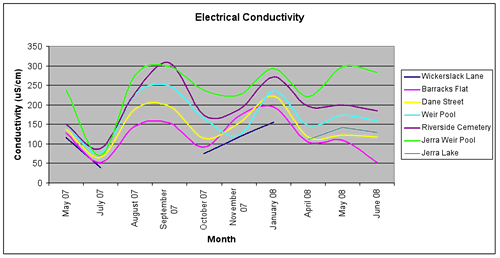
Figure 1 shows that there are significant variations in the surface water electrical conductivity for Queanbeyan. The variations are shown across all sites monitored by the council.
Monitoring and reporting of surface water quality data is critical for the Queanbeyan River, as the river is a tributary of the Murrumbidgee River which was reported by the Sustainable Rivers Audit to be in very poor ecological health. New development in the Queanbeyan Rivers catchment may also further erode the health of the catchment (MDBC, 2008).
About the data
Data for the monitoring sites covered in this report were from Queanbeyan City Council.
Data is also routinely reported at http://nratlas.nsw.gov.au. Department of Water and Energy (DWE) is responsible for quality control and on-going maintenance of the data collected in its databases.
Interpreting the data
Default environmental value
The Water Quality and River Flow Interim Environmental Objectives (EPA 1999) for NSW, which are still current, indicate that protection of aquatic ecosystems is the default environmental value for most water bodies in catchments associated with Boorowa Shire. Although individual councils are free to assign additional or different value through local processes and based on site-specific information, so far no councils in the Australian Capital Region have done so.
Default trigger values
The default trigger values used in this report were those values set out in ANZECC and ARMCANZ (2001). The values applicable to the Australian Capital Region are those for "south-east Australia for slightly disturbed ecosystems" (ANZECC and ARMCANZ 2001). The default trigger values for different water quality parameters for the protection of aquatic ecosystems are based on the type of water body in question. Compared to most other environmental objectives, the protection of aquatic ecosystems is one that requires more stringent water quality guidelines.
The median value (i.e. middle value of a data series) for each monitoring site in the shire over the reporting period was compared with the default trigger value from the guideline values suggested in ANZECC and ARMCANZ (2001). This approach was recommended when no environmental values were set, water quality objectives were not determined, local reference sites were unavailable and local site-specific information could not be sourced. This broad reporting approach cannot be used to assess 'compliance'; it is merely a warning system to alert natural resource managers.
The data was firstly sourced from the NSW Natural Resource Atlas, if the relevant data wasn’t available from this resource, the information supplied from the NSW Department of Water and Energy (DEW) was used. The data from the NSW Natural Resource Atlas generally provided daily data on stream flow and electrical conductivity, amongst others. Whereas the data supplied by the DEW had periodic samples of the data, however did include values for the turbidity and total phosphorus.
Electrical conductivity is a measure of the ability of water to conduct an electric current. This is considered an appropriate indicator of salinity, as it is proportional to the concentration of total dissolved salts in water.
Phosphorus is considered as a key indicator of eutrophication in Australian freshwaters because it is typically a limiting nutrient for primary production under natural conditions (Cullen 1986; Donnelly et al. 1992). Total phosphorus is analysed as it represents an aggregation of all fractions of phosphorus reaching the water column from various processes and it represents the potential maximum concentration of phosphorus available for biological uptake (NSW EPA 2000).
Australia has naturally turbid waters, owing to deeply weathered soils rich in clay-sized particles. These particles are readily transported to streams during storms. Because of their colloidal nature they remain suspended in the water column, resulting in high turbidity (Cullen 1986). In addition to natural causes, the turbidity of many waters has increased as a result of human-induced erosion through practices such as land clearing (agriculture and forestry), urbanisation, extractive industries and river regulation (Walker 1985). Turbidity is a measure of light scattering and absorptive properties of water, which are roughly proportional to the type and concentration of suspended matter. It is therefore commonly used as an indicator of the amount of suspended matter in the water column, although quantitative relationships between the two are difficult to define, because various types of suspended material have different light-scattering properties.
Additional data
Other potential sources of water quality monitoring data include the Community Access to Natural Resources Information (CANRI) website and the Waterwatch program.
References
MDBC, 2008, Sustainable Rivers Audit – A report on the Ecological Health of rivers in the Murray-Darling Basin, 2004-2007, Murray Darling Basin Commission, SRA Report 1, June 2008. Viewed at http://www.mdbc.gov.au/SRA on 10 October 2008.