Queanbeyan
Indicator: Riparian Conditions
Results for this indicator are also available for [an error occurred while processing this directive]
Please note: Text or data highlighted in this colour represent an update to this indicator for the period 2008/09.
What the results tell us for Queanbeyan
No quantitative information was available to assess change in riparian condition within the Queanbeyan City Council area during the current reporting period and the previous reporting period.
This current reporting period has seen six threatening processes which impact on riparian condition listed under the Threatened Species Conservation Act, 1995 and the Fisheries Management Act, 1994.
Council implemented the beginnings of the Queanbeyan River Corridor Plan of Management, part of the Murrumbidgee Catchment Action Plan (MCAP). This plan places ‘riparian zone management’ as a high priority issue for the Queanbeyan River (QCC 2008).
Condition of riparian zones in the City Council
The extent to which the condition of riparian vegetation and streambank disturbance across the City Council changed in the 2004-08 period is not known, as no comprehensive assessment of riparian condition was undertaken for the period and no other detailed City Council-wide information was available. During the 2008-09 period the condition of riparian vegetation and streambank disturbance along the Queanbeyan River has changed slightly with 1400m of riparian zone now removed of willow and other woody weeds.
Threats to riparian condition
Three processes relating to riparian condition have been listed as key threatening processes in the state (see Table 1) by the New South Wales (NSW) Scientific committee under the Threatened Species Conservation Act 1995. Fisheries Scientific Committee also listed, under the Fisheries Management Act 1994, three key threatening processes relevant to riparian areas.
| Name of threatening process | Date of Final Determination or Gazettal |
|---|---|
| Alteration to the natural flow regimes of rivers, streams, floodplains and wetlands (DECC, 2008a) | Final: 31 May 2002 |
| Clearing of Native Vegetation (DECC, 2008b) | Final: 21 September 2001 |
| Human-caused climate change (DECC, 2008c) | Gazetted: 17 November 2000 |
| Removal and degradation of native riparian vegetation (DPI, 2008a) | Final: 01 June 2005 |
| Installation and operation of instream structures and other mechanisms that alter the natural flow regimes of rivers and streams (DPI, 2008b) | Final: 01 June 2005 |
| Removal of large woody debris from NSW rivers and streams (DPI, 2008c) | Final: 01 June 2005 |
The impacts of these key threatening processes on riparian conditions and waterways include (DECC 2008 a, b; DPI 2008, a, b; DPI 2005a):
- bank erosion
- loss of biological diversity
- impairment of important ecosystem services for fish and invertebrates (e.g. removal of refuges used during flooding or drought or removal of spawning sites)
- reduced nutrient filtering capacity
- increased light penetration of the water-body and loss of shade and shelter for fish
- reduced inputs of organic carbon (for example, twigs and leaves)
- changes to stream behaviour (increased and decreased flow, seasonality, frequency, duration, magnitude, timing predictability, rate of rise and fall of water levels and altering surface and subsurface water levels)
- exotic plants such as Alligator weed (Alternanthera philoxeroides) reducing stream flow.
What is being done to protect riparian zones?
Queanbeyan City Council is working on actions from The Queanbeyan River Corridor Plan of Management (1998) with on-ground works along the Queanbeyan River. A major project of willow removal and revegetation has commenced with the employment of a team of indigenous trainees who have been undertaking TAFE units to gain their Certificate II in Conservation Land Management. The team has been undertaking the following tasks:
- removal of weeds in project area;
- revegetation of native vegetation in project area;
- fencing to protect and enhance native vegetation in project area;
- riparian zone management;and
- stream bank erosion control.
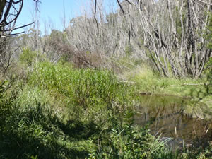
Figure 1 -A section of the Queanbeyan River after Willow
poisoning, but before removal and rehabilitation.
The Murrumbidgee Catchment Action Plan (CAP) sets the strategic direction for integrated catchment management actions. It details specific and measurable targets to be achieved over a 10-year timeframe and has been endorsed by the Australian and NSW Governments as a template for investment of funds available under National Action Plan for Salinity and Water Quality (NAP) and other programs. The directions and strategies for action set out in the Queanbeyan River Corridor Plan of Management (1999) and the Plan of Management for Jerrabomberra Creek (2006) are in keeping with the CAP model.
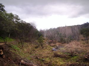
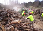
Figure 2 - A section of the Queanbeyan River that is heavily
choked with willows and other woody weeds.
The Murrumbidgee Catchment Management Authority (CMA) has provided Queanbeyan City Council with funding to undertake riparian restoration on-ground works by Traditional Owners and Aboriginal people of the Queanbeyan area in partnership with Queanbeyan City Council (QCC), the Local Aboriginal Community, Department of Lands, Department of Environment and Climate Change, TAFE, Murrumbidgee CMA and other stakeholders. This project aims to:
- increase the capacity and involvement in NRM of Traditional Owners and other Aboriginal peoples of the Queanbeyan area;
- increase the capacity of the the wider community to improve NRM by incorporating Aboriginal cultural heritage sites and values in the Murrumbidgee catchment; and
- restore the Queanbeyan River Corridor, Mount Jerrabomberra and natural areas of public and private land in accordance with the project milestones.
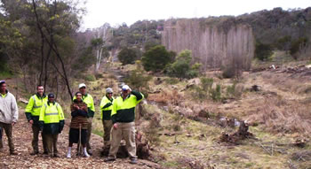
Figure 3 - The Queanbeyan River Restoration Team assessing the
work to be done.
A wide range of activities has been undertaken during the 2008-09 reporting period under the Willow Removal and Revegetation Program the team has been engaged in:
- continuing woody weed removal with a large area of willows already cut and mulched;
- seed collection and plant propagation at our nursery;
- some planting and revegetation work; and
- an access track along the river has been cut.
 5.
5. 6.
6.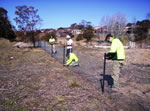
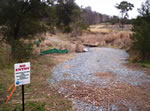
Figure 4 - New access points were created in order to cope with the heavy machinery required on the site.
Figure 5 -
The Queanbeyan River Restoration Team assists contracted chippers with disposal of dead willows.
Figure 6 - The Queanbeyan River Restoration Team carryout fencing works.
This project aims to preserve remaining biodiversity assets and increase vegetation cover and condition within targeted areas of the Queanbeyan urban landscape.
In addition the project will improve the condition of targeted tributaries of the Murrumbidgee River. The outcomes of this component are to:
- form a Queanbeyan Riparian Restoration Team from the Traditional Owners and Aboriginal people of the Queanbeyan area to increase their capacity to be involved in NRM; and
- provide training and accreditation of the Queanbeyan Riparian Restoration Team to increase their capacity to be involved in NRM.
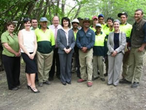
Figure 7 - The team have a visit from the then NSW Minister
for the Environment, Carmel Tebutt and other dignitaries.
The project also provides for on-ground riparian restoration works by the Queanbeyan Riparian Restoration Team. Actions to protect and enhance Aboriginal cultural heritage sites and natural and biodiversity values of riparian areas within the project area include:
- removal of weeds;
- revegetation of native vegetation;
- fencing to protect and enhance native vegetation;and
- construction of access and interpretive facilities.
Comprehensive assessment and recognition of Aboriginal cultural heritage sites and values within the project area is undertaken by the Queanbeyan Riparian Restoration Team.
Other projects
The Murrumbidgee Catchment Action Plan (CAP) sets the strategic direction for integrated catchment management actions. It details specific and measurable targets to be achieved over a 10-year timeframe and has been endorsed by the Australian and NSW Governments as a template for investment of funds available under National Action Plan for Salinity and Water Quality (NAP) and other programs. This fits in with the Queanbeyan River Corridor Plan of Management (1999) and the Plan of Management for Jerrabomberra Creek (2006).
The Murrumbidgee Catchment Management Authority (CMA) has provided Queanbeyan City Council with funding for the willow removal and restoration program on Jerrabomberra Creek and the Queanbeyan River. This program was identified as high importance by both the Murrumbidgee CMA and the Queanbeyan City Council. A wide range of activities have been undertaken during the reporting period with the willows poisoned and contractors engaged to cut and mulch the trees on both the Queanbeyan River and Jerrabomberra Creek. Substantial landscaping and planting of local endemic species has been undertaken along the river corridor.
The following has been undertaken as a result in 2007:
- Queanbeyan City Council has developed a vegetation management plan for targeted riparian areas along the river.
- Willow control and revegetation activities implemented in accordance with approved vegetation management plan
- Project on-ground works to achieve the following
- 500 metres of river/creek native riparian vegetation protected and enhanced along Jerrabomberra Creek.
- 1200 metres of native riparian vegetation established on Queanbeyan River.
The plan will also detail on-going maintenance activities proposed to be undertaken on these sites.
This project aims to preserve remaining biodiversity assets and increase vegetation cover and condition within targeted areas of the Queanbeyan urban landscape. In addition the project improves the condition of the targeted tributaries of the Murrumbidgee River. These objectives will be achieved through the implementation of actions identified within the Plans of Management:
- develop vegetation plans of management for targeted riparian areas within the catchments
- through the implementation of the vegetation plans of management improve the condition of the Queanbeyan River and Jerrabomberra Creek
- protect and actively manage high value native vegetation communities
- promote current recommended practise to enhance biodiversity within urban landscapes.
The Outcomes of this component are to:
- protect and enhance priority terrestrial vegetation sites
- protect riparian areas from degrading influences
- improve aquatic ecosystem function and improve in-stream habitat
- improve water quality by reducing in-stream sediment
- improve biodiversity values within terrestrial and riparian landscapes.
References
DECC - Department of Environment and Climate Change
Department of Environment and Climate Change (NSW) (2008a) NSW Scientific Committee—Final Determination, Alteration to the Natural Flow Regimes of Rivers, Streams, Floodplains and Wetlands—Key Threatening Process Declaration, NSW Department of Environment and Climate Change, viewed 14 October 2008, http://www.threatenedspecies.environment.nsw.gov.au/tsprofile/profile.aspx?id=20002
Department of Environment and Climate Change (NSW) (2008b) NSW Scientific Committee—Final Determination, Clearing of Native Vegetation—Key Threatening Process Declaration, NSW Department of Environment and Climate Change, viewed 14 October 2008-10-14 http://www.environment.nsw.gov.au/determinations/ClearingNativeVegKTPListing.htm
Department of Primary Industries (NSW) (2008a) Removal of large woody debris from NSW rivers and streams, NSW Department of Primary Industries, viewed 10 October 2008 http://www.dpi.nsw.gov.au/fisheries/habitat/publications/threats/removal-large-woody-debris
Department of Primary Industries (NSW) (2008b) Degradation of native riparian vegetation along NSW water courses, NSW Department of Primary Industries, viewed 10 October 2008
Department of Primary Industries (NSW) (2005a) Fisheries Scientific Committee Recommendation—Installation and Operation of Instream Structures and Other Mechanisms that Alter Natural Flow Regimes of Rivers and Streams, NSW Department of Primary Industries, viewed 11 August 2005, http://www.fisheries.nsw.gov.au/__data/assets/pdf_file/5284/FR21_dams.pdf.
DPI - Department of Primary Industries
Office of the Commissioner for the Environment (2004) Australian Capital Region State of the Environment Report 2004, Office of the Commissioner for the Environment, Canberra (see Riparian Condition)
Queanbeyan City Council Council (2008) Queanbeyan River Corridor Plan of Management, Queanbeyan City Council Council, viewed October 14 2008 http://www.qcc.nsw.gov.au/page.aspx?page=3085