Queanbeyan
Indicator: Land Use
Results for this indicator are also available for [an error occurred while processing this directive]
What the results tell us for Queanbeyan
Maps of land use in | 1997 | 2000 | 2004 | 2008 (see below)
At the time of reporting, there was no current landuse data available for the Queanbeyan City Council area for the 2008 reporting period. As such, it is unknown whether there have been any major landuse changes in the Council area since 2004.
In 2004, the main landuse in Queanbeyan City Council area was agriculture, which made up 54% of the total Council area. The other major landuses were bushland and urban, comprising approximately 17% and 15% of the council area respectively.
How is the land being used now?
As reported in 2004, of the total Council area (17,288 hectares), the dominant landuses were agriculture (54%), bushland (17%) and urban (15%) (see Figure 1). Also noted in 2004, Queanbeyan City comprises the entire area of urban land.
Figure 1. Major landuse in Queanbeyan City Council area June 2004
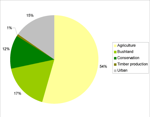
Source: Queanbeyan City Council State of the Environment Report 2004
What has changed and why?
With no available landuse data for the current reporting period it is unknown whether there have been major landuse changes in the Council area since the 2004 report.
It was noted in the previous reporting period that the major broadscale changes in 2004 in the city council area were decreases in land under bushland, with an increase in land classified as conservation see Table 1.
| Landuse Category | 1997 | 2000 | 2004 |
|---|---|---|---|
| Agriculture | 54% | 55% | 54% |
| Bushland | 23% | 22% | 17% |
| Conservation | 7% | 7% | 12% |
| Quarries | 0.2% | 0.2% | 0.2% |
| Timber production | 0.4% | 0.4% | 1% |
| Urban | 15% | 15% | 15% |
| Waterbodies | 0.01% | 0.01% | 0.01% |
Source: Queanbeyan City Council State of the Environment Report 2004
Agriculture
At the time of reporting, there was no current agriculture landuse data available for the City Council area for the 2008 reporting period. The total amount of land under agricultural production in the council has remained relatively stable since 1997 (see Table 1).
Timber production
At the time of reporting there was no current timber landuse data available for the City Council area for the 2008 reporting period.
In 2004, the amount of land under timber production more than doubled during the previous reporting period although this was from a low level (an increase of about 80 hectares). This was because of a private softwood plantation being established on the Council area's western boundary. This land was predominantly privately owned bushland before conversion to plantation.
Bushland
At the time of reporting, there was no current landuse data relating to bushland available for Queanbeyan City Council.
As noted in 2004, the area of bushland appeared to decrease by 910 hectares. The change was predominantly due to bushland areas being dedicated within reserves and mapped as conservation in 2004 rather than as bushland, and thus did not reflect an actual decrease in bushland on the ground. A small area of bushland was lost, however, when it was converted to rural residential.
Conservation
At the time of reporting, there was no current landuse data relating to conservation available for Queanbeyan City Council area.
In 2004 the area under conservation in the council area increased by approximately 888 hectares and represented a significant increase in the area of conservation lands within the Council area. The majority of this, approximately 822 hectares, was due to Crown lands (shown as bushland in 1997 and 2000) being converted/transferred to nature reserves under the Southern Comprehensive Regional Assessment (CRA) to help develop a comprehensive, adequate and representative reserve system to protect forest ecosystems and conserve biodiversity. Three new nature reserves were created—Cuumbeun, Stony Creek and Wanna Wanna. (For more information about this process, see www.racac.nsw.gov.au/overview/cras.shtml).
Future planning
Queanbeyan City Council area is comprised of the former Queanbeyan City and part of Yarrowlumla Shire. Each of the former councils had developed a Local Environment Plan (LEP), in 1998 for Queanbeyan City and in 2002 for Yarrowlumla Shire. Queanbeyan City Council is currently reviewing these LEPs and will prepare a new, standardised LEP to cover the entire council area.
About the data
The landuse maps and statistics reported in this section are based on data from NSW State Government agencies, Councils and satellite images. The primary purpose of the mapping was to assess trends in landuse change and not to provide an accurate account of the actual areas changed.
Queanbeyan City Council provided LEP information and cadastral data. In general the data provided by council and State Government departments showed a higher level of detail than satellite classifications. Therefore, these layers were usually used as the primary source of data and supplemented by satellite imagery (Landsat data and SPOT VI data) as needed (mostly for agricultural landuses and bushland).
All landuse maps for Queanbeyan City Council area were provided to Council for checking and correction, particularly for 2004 and 2000.
All percentages shown in this indicator are a percentage of the council area and not a percentage of the landuse type. The areal extents of the various landuse types (hectares) were calculated from data that had been adjusted (normalised) to take account of (usually minor) differences between the size of Queanbeyan City Council area as gazetted by City Council, and the size calculated from spatial data.
References
Queanbeyan City Council (2004) Queanbeyan City 2004 Structure Plan, Queanbeyan City Council, Queanbeyan, viewed 20 October 2008, http://www.queanbeyan.nsw.gov.au/Documents/EQAEAMZTELH.pdf.