Queanbeyan
Indicator: Groundwater
Results for this indicator are also available for [an error occurred while processing this directive]
Please note: Text or data highlighted in this colour represent an update to this indicator for the period 2008/09.
What the results tell us for Queanbeyan
Groundwater in the Queanbeyan City Council area is generally of good to moderate quality and low yield (DLWC 1999), with a steadily decreasing water table (DWE 2008).
Groundwater supplies
Groundwater flow in the area is mostly from local flow systems in sedimentary and intrusive Palaeozoic rock (DPI 1998), which provide a mix of good to moderate quality groundwater. Bore hydrograph data indicate a consistent seasonally adjusted drop in water levels for the majority of bores over the reporting period 2004 to 2009, continuing a trend observed since 1991. The Water Table depth is presented in Figure 1 for each of the 16 bores in Queanbeyan. A low natural rainfall is likely to be the most significant factor keeping bore levels low.
Figure 1. Water table depth for Queanbeyan
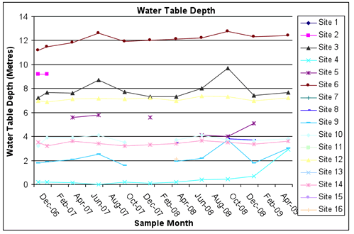
Source: Queanbeyan City Council
Figure 1 was updated to include data for 2008/09.
Groundwater use
Total groundwater extraction in Queanbeyan is less than 10 GL/yr compared with natural recharge of more than 500 GL/yr (AWR 2000). This is considered a low level of extraction (extraction is 0 to 29% of recharge), and sustainable for the entire City. However, the Department of Water and Energy (DWE) has rated the threat to groundwater quality as low to moderately high (DLWC 2001). Queanbeyan City Council does not extract groundwater as part of its water supply.
The State Water Corporation (SWC), on behalf of the Department of Water and Energy, administers much of the water allocation in rural NSW. To recover the cost of administration, infrastructure and future investment, SWC charges each licensed user a base charge, either $51.46 for non-monitored or $118.56 for monitored areas plus a per megalitre access charge. As part of the Murrumbidgee groundwater area, Queanbeyan groundwater users are charged $1.03/ML access charge and $0.51/ML usage charge. Although base charges are consistent throughout the State, access and usage charges are the lowest in the State (SWC 2008).
Groundwater quality
Groundwater salinity in Queanbeyan is generally moderate (DLWC 1999), making it of low quality (1,000-3,000 mg\L) and suitable for only livestock and limited domestic and industrial use. No area within the City has been classed as a high salinity hazard for the period up to 2050 (AWR 2005). The salinity (electrical conductivity) measurements for Groundwater in Queanbeyan over the reporting period, is presented in Figure 2.
Figure 2. Electrical Conductivity in Queanbeyan’s Groundwater.
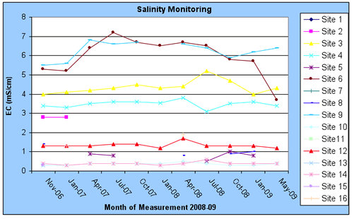
Source: Queanbeyan City Council
Figure 2 was updated to include data for 2008/09.
Managing groundwater demand
Water conservation measures
Queanbeyan is within the area of the Murrumbidgee Catchment Management Authority (MCMA). The MCMA was established to guarantee the protection and sustainable development with in its area of administration, including impact on water quality and use. At the time of writing, the MCMA’s Action Plan was not readily available for reporting on the CMA’s water management targets in Queanbeyan (MCMA 2007).
Laws and policy
Outside of regional CMA policies, the use and treatment of groundwater is generally the same throughout NSW. Specifically water management and use in the Queanbeyan is covered under:
- NSW Water Extraction Monitoring Policy (2007): Designed to increase the extent of active monitoring of water extraction to cover 90% of the total volume of water extracted for each water sharing plan.
- NSW Water Extraction Monitoring Standards (2005): Designed to increase the quality of groundwater extraction monitoring.
- National Water Initiative (2004): NSW is a party to the National Water Initiative (NWI), a national initiative to coordinated Australia's water supply to guarantee the greatest possible social, economic, and environmental benefits.
- NSW NWI Implementation Plan: Addresses the initiatives set out in the NWI specific to the State of NSW.
- Living Murray and Snowy Initiatives (2002): Initiative between Federal and State governments concerned predominately with surface water, however, may indirectly impact on groundwater.
- Water Management Act 2000 (NSW): Aim is to protect the supply of water to the environment and water users. Its introduction has been gradual and once fully implemented will largely supersede the Water Act 1912.
- NSW Groundwater Quality Protection Policy (1998): Aim is largely to protect groundwater resources against pollution.
- Local Government Act 1993 (NSW): Covers the quality of water supplied for human consumption by local Council, including groundwater as a source.
- Water Act 1912 (NSW): Largely superseded by the Water Management Act 2000 but some provisions still apply.
- Australian Constitution (1901): Section 100 of the Constitution outlines the States primacy over the Commonwealth in terms of laws and regulations affecting the use and conservation of water.
About the data
Data was supplied by Queanbeyan City Council and the NSW Department of Water and Energy. Threshold salinity values of 800 µS/cm and 1,600 µS/cm were used for water quality assessment. They represent the maximum desirable water standard set by the World Health Organisation for human consumption (800 µS/cm) and a threshold at which adverse environmental changes can be expected (1,600 µS/cm) (NHMRC and ARMCANZ 1996).
Groundwater with less than 1,000 mg of salt per litre is also considered good quality and suitable for drinking water and most uses; groundwater with 1,000–3,000 mg of salt per litre is considered fair to poor and suitable for livestock, some domestic and limited industrial uses (DLWC 1999).
mg/L = milligrams per litre
References
Australian Water Resources (2000) National Land and Water Audit.
Beale G, Miller M, Barnett P, Summerell G, Gilmore R and Hoey D (2004) NSW Coastal Salinity Audit, Department of Infrastructure Planning and Natural Resources, Sydney, online at http://www.dnr.nsw.gov.au/salinity/science/pdf/coastal_audit1.pdf.
Department of Land and Water Conservation (NSW) (1999) Groundwater Quality Protection Policy, Department of land and Water Conservation, Sydney, on line at http://www.dnr.nsw.gov.au/water/pdf/nsw_state_groundwater_quality_policy.pdf.
Department of Land and Water Conservation (NSW) (2001) Groundwater Vulnerability Map and Explanatory Notes, Department of Land and Water Conservation, Sydney, on line at http://www.dnr.nsw.gov.au/water/pdf/lachlan_vulnerability_map.pdf.
Department of Primary Industries (NSW (1998) Geological Map of New South Wales (1:250000 scale)
Department of Water and Energy (NSW (2006) 2005/06 Water Supply and Sewage Benchmarking Report on line http://www.deus.nsw.gov.au/Publications/dwe_nsw_water_supply_and_sewerage_benchmarking_report_2005-06.pdf
Department of Water and Energy (NSW) (2008) – Bore Location Information supplied in GIS format.
Murrumbidgee Catchment Management Authority (NSW) (2007) SRCMA Annual Report 2006/2007 online at
http://www.murrumbidgee.cma.nsw.gov.au/uploads/media/Annual_Report_06-07_Section_1_01.pdf
NHMRC and ARMCANZ (1996) Australian Drinking Water Standards, National Health and Medical Research Council and Agricultural Resources Management Council of Australia and New Zealand, Canberra.
Queanbeyan City Council 2007 (NSW) (2007) Annual Report, online at
http://www.qcc.nsw.gov.au/page.aspx?page=61
State Water Corporation (NSW) (2008) Water Management Charges for Licensed Water Users on line http://www.statewater.com.au/watdel/water_mgt_charges_for_licensed_water_20080124.pdf