Gundagai
Please note: Text or data highlighted in this colour represent an update to this indicator for the period 2008/09. All rainfall figures have been updated on this page.
Rainfall Analysis
The main rainfall observing site used in this analysis was Mt Horeb - Marathon (Bureau of Meteorology Station No. 072154), which is 17 km from Gundagai and has records beginning in 1926. Rainfall observations at Gundagai (No. 070069) began in 1893; the station closed in 1971. There is a high degree of correlation between the two sites, which allowed the creation of a continuous time series from 1893 to the present (see Appendix 2 for further information).
Note that in the following analyses rainfall totals for individual months or years (where the year is defined as the 12 months from July to June) are compared to the long-term average (or climatology) from 1961-1990. A 30-year period is used to calculate climatological averages to conform with World Meteorological Organisation practice; this takes into account year-to-year variations and less frequent events such as El Niño or La Niña. This particular 30-year period is used internationally as a standard climatological average period.
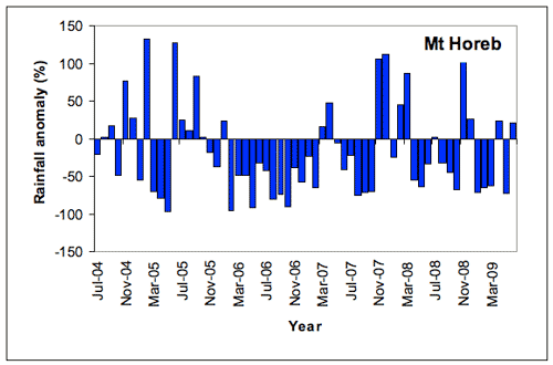
As shown in the table below, Mt Horeb was drier than average in all five years in the period 2004/05-2008/09. The driest year was 2006/07, when rainfall was 39.6% below the long-term average at 474.6 mm for the year. This was the fourth driest Jul-Jun 12 month period since the record at Mt Horeb began in 1893, and the driest year in the last 75 years. The wettest years in the last five years were 2004/05 and 2008/9, when rainfall was 5.8% below average.
| Rainfall Statistics | Gundagai (Mt Horeb) | ||||
|---|---|---|---|---|---|
2004/5 |
2005/6 |
2006/7 |
2007/8 |
2008/9 |
|
| Annual Total* (mm) | 740.8 |
678.8 |
474.6 |
655.8 |
637.6 |
| Anomaly (mm) | -45.3 |
-107.3 |
-311.5 |
-130.3 |
-148.5 |
| Anomaly (%) | -5.8 |
-13.7 |
-39.6 |
-16.6 |
-18.9 |
| Mean (1961-1990) (mm) | 786.1 |
||||
*Note: annual totals were calculated for the 12 months July-June.
Monthly Rainfall, 2004-2009
A comparison of monthly rainfall totals with the long-term monthly average rainfall at Mt Horeb (Figure 1) shows that most of the period experienced below-average rainfall interspersed with short periods of average or above average rainfall.
The dry conditions during 2006/7 reflect the impact of the El Niño event during this period while the increase in rainfall at the end of 2007 reflected the development of a La Niña event. However, generally dry conditions have redeveloped from January 2008 to May 2009 apart from the rainfall in November-December 2008 which was related to another La Niña event.
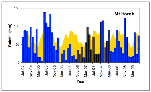 |
Of the 60 months in this period, 35 months (58% of the record) had below-average rainfall at Mt Horeb (Figure 2). There was a prolonged period of below-average rainfall between November 2005 to February 2007 with shorter periods of dry conditions during autumn 2005, June to October 2007, April to October 2008 and February 2009 to May 2009. The driest month for the period was February 2006 with 2 mm (long term average for February is 39.8 mm) whilst May 2005 recorded 2.6 mm. Generally average rainfall occurred during the periods August 2004 to February 2005 and March to May 2007 with above average rainfall during the periods June 2005 to October 2005 and November 2007 to March 2008. The wettest month was June 2005 with 137.8 mm (long term average for June is 60.7 mm). This was in the top 10% of wet Junes on record, possibly as far back as 1893.
 |
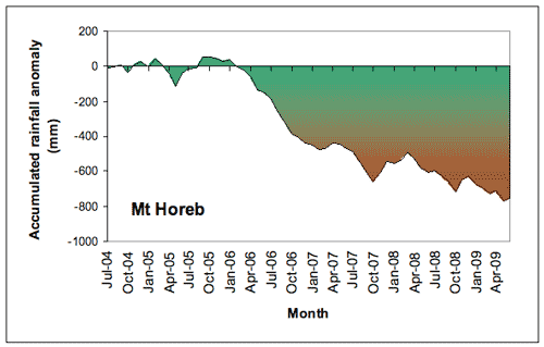
The result of the generally dry conditions at Mt Horeb during 2006/7 is reflected in the accumulated rainfall deficit (Figure 3). While the accumulated monthly rainfall totals were close to average until January 2006, there was a rapid increase in the deficit during 2006 which continued through 2007 with a slow increase through 2008 and 2009. The increased deficit on 2006/7 reflects the dry conditions due to the impact of the El Niño event during this period. The accumulated deficit for the five year period was 754.9 mm (96% of the Jul-Jun average rainfall).
 |
The climatological context for rainfall at Mt Horeb (Gundagai)
The long-term perspective
As is typical of the region, Mt Horeb has experienced large fluctuations in annual (July-June) rainfall, including several extended periods of above- or below-average rainfall since records began in 1892. In general, annual rainfall was lower and less variable early in the 20th century, followed by a period of greater variability. Rainfall variability has been moderate since about 1980 (Figure 4). The recent dry period is reflected in other parts of the long term record such as the late 19th and early part of the 20th Century and the period from the late 1920’s through to the end of World War 2. To this point in time this recent dry period can only be considered as part of the long term variability in rainfall experienced in the region.
- Rainfall in the late 19th and early 20th century was generally below average (to about 1950), with the notable exception of a short wet period in the 1910s. Since then annual rainfall totals have been more variable.
- Several wetter-than-normal years around 1950 and 1960 produced a generally wetter period then.
- A generally drier period around 1980 was followed by some wetter years during the 1980s. Since 1994 conditions have been generally drier than average with below average conditions persisting since 2001.
The wettest year (July-June) on record was 1955/6 (1199 mm); the driest year was 1928/9 (381 mm).
![Figure 4. Annual (July-June) rainfall at Mt Horeb from 1893/4 to 2008/9 depicted as deviations from the long-term mean. A 5-year running mean is superimposed to highlight wetter and drier periods. [Deviations were calculated as the difference between the rainfall for each year and the mean for the period 1961-1990 (scale in mm).]](../images/gundagai/rain04.gif) |
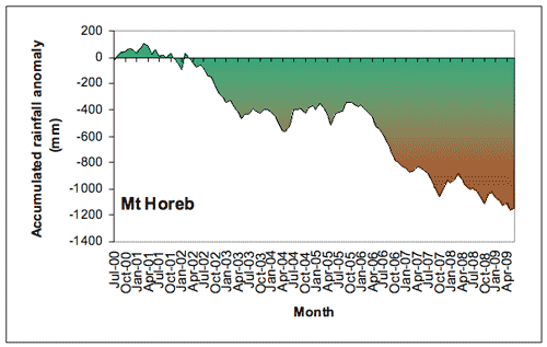
The impact on accumulated rainfall since 2000 of two successive El Niño events without a compensating wet period is shown in Figure 5. Accumulation was close to the norm until 2002 when there was an increase in the deficit during 2002/3. The deficit then flattened throughout 2004/5 before rapidly dropping again during 2006/7 with a slow increase continuing through 2008/9. During this period there were 65 months (60%) of rainfall deficit. The total accumulated deficit over this period is 1151.6 mm (146% of Jul-Jun average).
 |
About the data
