Eurobodalla
Please note: Text or data highlighted in this colour represent an update to this indicator for the period 2008/09. All rainfall figures have been updated on this page.
Rainfall Analysis
The main rainfall observing sites used in this analysis were Moruya Heads Pilot Station (Bureau of Meteorology Station No. 069018) and Bodalla (No. 069036), which is 14.7 km from Narooma. Both sites have records commencing in 1876, and the record at Moruya is complete. Data from nearby stations were used to calculate values for months with missing data at Bodalla (see Appendix 2 for further information).
Note that in the following analyses rainfall totals for individual months or years (where the year is defined as the 12 months from July to June) are compared to the long-term average (or climatology) from 1961-1990. A 30-year period is used to calculate climatological averages to conform with World Meteorological Organisation practice; this takes into account year-to-year variations and less frequent events such as El Niño or La Niña. This particular 30-year period is used internationally as a standard climatological average period.
As shown in the table below, Moruya and Bodalla were both drier than average in all five years in the period 2004/05-2008/09. The driest year at Moruya was 2008/09, when rainfall was 41.2% below the long-term average while the driest year at Bodalla was 2007/8 where rainfall was 30.3% below average. The wettest year in the last five years was 2004/05 at Moruya (18.1% below average) and 2006/7 at Bodalla (5.5% below average).
| Rainfall Statistics | Moruya | Bodalla | ||||||||
|---|---|---|---|---|---|---|---|---|---|---|
2004/5 |
2005/6 |
2006/7 |
2007/8 |
2008/9 |
2004/5 |
2005/6 |
2006/7 |
2007/8 |
2008/9 |
|
| Annual Total* (mm) | 878.8 |
856.0 |
859.7 |
660.8 |
630.6 |
848.9 |
867.6 |
990.3 |
730.5 |
742.4 |
| Anomaly (mm) | -193.7 |
-216.5 |
-212.8 |
-411.7 |
-441.9 |
-199.3 |
-180.5 |
-57.9 |
-317.7 |
-295.7 |
| Anomaly (%) | -18.1 |
-20.2 |
-19.8 |
-38.4 |
-41.2 |
-19.0 |
-17.2 |
-5.5 |
-30.3 |
-28.5 |
| Mean (1961-1990) (mm) | 1072.5 |
1048.2 |
||||||||
*Note: annual totals were calculated for the 12 months July-June.
Monthly Rainfall, 2004-2009
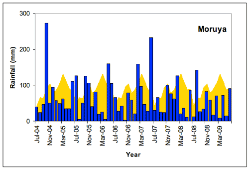
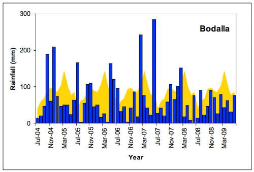
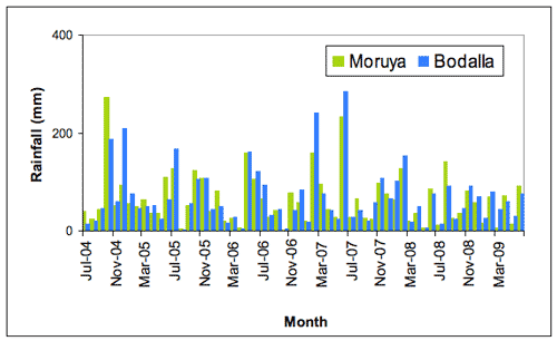
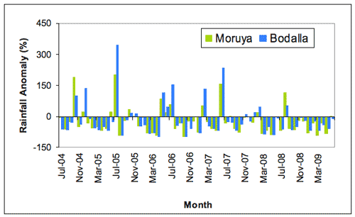
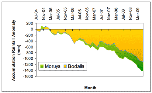
A comparison of monthly rainfall totals with the long-term monthly average rainfall at Moruya and at Bodalla (Figure 1a and b) shows that generally below average rainfall was experienced across the region during this period with only short periods of well above average rainfall. These periods were of only one or two months’ duration. Figures 2 and 3 indicate that the rainfall patterns at both locations were indeed very similar with only one or two months where rainfall differed considerably and tended to be with higher rainfall situations. The generally dry period of below-average rainfall in 2006-2007 was associated with an El Niño event with the dry period persisting through 2008/9. The rainfall in November 2007-January 2008 was related to a La Niña event while there was little or no impact in the region on rainfall of the La Niña event of late 2008.
a b |
 |
Of the 60 months in this period, only 15 (25% of the record) had above-average rainfall at Moruya and 14 months (23%) at Bodalla over this period. Since July 2007 there have only bee 4 months of above average rainfall at both Moruya and Bodalla. The driest individual month at Moruya was October 2006 with 2.2 mm (long-term average for October is 94.6 mm) and at Bodalla it was August 2005 with 3.2 mm (long-term average for August is 60.4 mm). Conditions were significantly wetter than normal at Moruya only in October 2004, May to July 2006, February 2007 and June 2007 and at Bodalla in October 2004, December 2004, June 2005, May to July 2006, February 2007 and June 2007. The wettest month at Moruya was October 2004 with 273.8 mm (long term average for October is 94.6 mm) and at Bodalla it was June 2007 with 284mm (long term average 85.2 mm). In June 2007 Moruya also recorded 231.8 mm. The June 2007 rainfall at Bodalla was the eighth highest June value on record for Bodalla since 1876.
 |
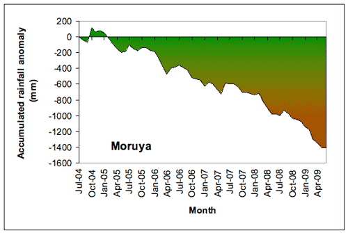
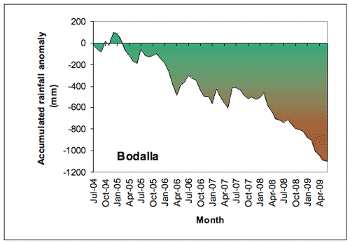
The results of the generally dry conditions at Moruya and Bodalla can be seen in Figure 4. Both Moruya and Bodalla show similar trends with an increase in rainfall deficit commencing in 2005 and persisting through to 2009 with only short periods where the deficit flattened out due to the above average rainfall of individual months. The effects of successive months with below-average rainfall has lead to an accumulated deficit for the period of 1405.8 mm at Moruya (131% of the Jul-Jun Moruya average) and 1048.2 mm at Bodalla (105% of the Jul-Jun Bodalla average). From this data and Figure 4 it can be seen that over this period, Moruya experienced below average rainfall more often than at Bodalla even though Moruya was located on the coast.
a b
|
The climatological context for rainfall at Moruya and Bodalla
The long-term perspective
As is typical of the region, Moruya and Bodalla have experienced large fluctuations in annual (July-June) rainfall, including several extended periods of above- and below-average rainfall since records began in 1876 at Moruya (and in 1910 at Bodalla). In general, annual rainfall was lower and less variable early in the 20th century, followed by a period of greater variability. Rainfall variability has been lower since about 1980 (Figures 5 and 6). The dry period evident in the last part of the records at both Moruya and Bodalla is reflected in other parts of the record such as the early 20th century and the 1937-45 period and therefore must be considered as lying within natural variability.
- Rainfall at Moruya in the late 19th and early 20th century was generally below average (to about 1950), punctuated only by a few particularly wet years. Since then annual rainfall totals have been more variable.
- Several wetter-than-normal years in the 1950s and the mid 1970s resulted in spells of above-average rainfall.
- A generally drier period around 1980 was followed by slightly above-average rainfall until the early 1990s. Since 1992 conditions have been generally drier than average with it being particularly dry since 2001.
The wettest year (July-June) on record at Moruya was 1974/75 (1961 mm); the driest year was 1884/85 (448 mm). The wettest year (July-June) on record at Bodalla was 1974/75 (2070 mm); the driest year was 1979/80 (440.8 mm).
![Figure 5. Annual (July-June) rainfall at Moruya from 1876/7 to 2008/9 depicted as deviations from the long-term mean. A 5-year running mean is superimposed to highlight wetter and drier periods. [Deviations were calculated as the difference between the rainfall for each year and the mean for the period 1961-1990 (scale in mm).]](../images/eurobodalla/rain07.gif) |
![Figure 6. Annual (July-June) rainfall at Bodalla from 1885/6 to 2008/9 depicted as deviations from the long-term mean. A 5-year running mean is superimposed to highlight wetter and drier periods. [Deviations were calculated as the difference between the rainfall for each year and the mean for the period 1961-1990 (scale in mm).]](../images/eurobodalla/rain08.gif) |
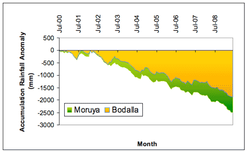
The extent of the dry period that commenced in 2002 across the region is indicated in Figure 7. Both locations give a similar pattern with a continued increase in the rainfall deficit from 2005 and is a continuation of the dry period from 2002. The deficit eased slightly more at Bodalla in 2003 but then along with Moruya continued with an increase in the deficit through to 2008 and reflect the fact that there were two successive El Niño events (2002/3 and 2006/7) without a compensating wet period between them. During this 9 year period there were 81 months (75%) of rainfall deficits at Moruya and 82 months (76%) at Bodalla. The total rainfall deficits over this period are 2486.1 mm at Moruya (232% of Jul-Jun annual total) and 1882.5 mm at Bodalla (180% of Jul-Jun annual total).
a b |
About the data