Bega Valley
Indicator: Water Use
Results for this indicator are also available for [an error occurred while processing this directive]
Please note: Text or data highlighted in this colour represent an update to this indicator for the period 2008/09.
What the results tell us for the Bega Valley
Drinking water supply in the Bega Valley is an extensive and complex system of reservoir supplies, river sources and bores. These are currently operated as four independent systems, however there is a current project to link the Bega supply to the Tantawanglo-Kiah system by pipeline which will provide operational flexibility and assist in meeting demand in the most limited part of the system.
Water restrictions have been required in the Kiah/Tantawangalo system on a number of occasions during this reporting period and they had modest success in holding down demand. None of the systems reported any periods where water restrictions applied. Major infrastructure development is in progress and planned, including drinking water treatment plants on Yellow Pinch and Ben Boyd reservoirs.
Supply- how much water could we have?
The complex Bega Valley reticulated drinking water system supplies about 11,000 properties in the Shire. In summer there is also a major influx of holidaymakers, which temporarily triples the population of the coastal towns.
The most northerly component of the system is that supplying Bermagui. The Brogo River (brogo Dam) provides water for supply to Quaama, Cobargo, Bermagui, Beauty Point, Wallaga Lake and Akolele. Brogo River is the main source of supply for the whole system, because of the security of supply from this source. Brogo dam is primarily an irrigation supply dam, and is located just upstream of the Brogo river pump station that supplys reticulated water to the system. The dam has the capacity of 9,000 ML, and is operated by State Water. The dam has adequate storage to meet current and future demands. Most of the water released from Brogo Dam is for dairy pasture irrigation with other uses being environmental flows, stock and domestic uses, riparian uses and dairy washdown.
Couria Creek usually only supplies Wallaga Lake, Wallaga Lake Village Village and Akolele (the latter of which are located in the Eurobodalla Shire and for which the Bega Valley Shire is the Water Supply Authority). Tilba Dam has not been used recently.
The Bemboka river supplies a small population at Bemboka. Upstream is Cochrane Dam, a 2,700 ML hydroelectricity dam supplying irrigation water operated by Eraring Energy. This system is very small with low demand. Water sharing and dam release arrangements are generally serving Bemboka well.
The Bega system is central in location, and at present does not link into the other systems. The Bega River alluvium supplies water via the six Bega Bores to Bega, Tarraganda, Kalaru, Tathra and Mogareeka. When the Bega River is flowing the aquifer is fully charged. The Bega-Tathra system has adequate capacity to serve existing and future customers, as the bores are located in a large alluvial aquifer at the lower end of the largest catchment in the Shire. Droughts and extraction by irrigators can cause some problems due to localised drawdown around the borefield. There is a large volume of water in aquifer storage so supply is adequate during low surface flows.
The most southerly part of the supply is the Tantawanglo-Kiah system.This has the ability to transfer water between northern and southern components of the supply systems, as required by the differences in availability. The northern sources are Tantawanglo Creek and Yellow Pinch Dam, primarily supplying Candelo, Wolumla, Merimbula, Tura Beach and some rural connections. Yellow Pinch Dam is operated by Bega Valley Council and is a reticulated water supply dam of 3,000 ML capacity. The southern sources are the five Kiah bores drawing water from the Towamba River alluvial aquifer, and Ben Boyd Dam. This is a relatively small dam of 800 ML capacity.
This the largest system in the Shire with the highest population growth rate but the least secure supply. It is affected by drought and the maximum system yield of 2,900 ML/a is rarely achievable due to low stream flows and environmental flow restrictions. Future water sharing plans and environmental flow restrictions are likely to reduce yields further. Current demand is close to system capacity and system augmentation is required to improve supply security.
A substantial proportion of the total water availability is drawn from rivers, creeks and associated alluvial aquifers, and is therefore highly dependant on rainfall. Dam capacity and percentage fullness therefore only provide a partial picture of overall water availability. The largest dams are for irrigation supplies, and are drawn down to very low levels each year. For example the largest dam, Brogo Dam , was reduced to 12% of its capacity during the 2004 reporting period. The percentage fullness of the dams under control of Bega Valley Council (Yellow Pinch Dam and Ben Boyd dam) between July 2004 and June 2008 are shown in Figure 1 below.
Figure 1. Percentage fullness of supply dams
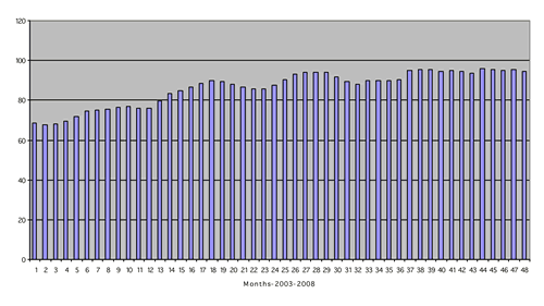
In the previous reporting period the dams fell to 58% in February 2003. Over the whole eight years from 2000 to the present, full capacity was not reached. The lowest level in this period was 68% in August and September 2004.
Table 1 below table details the average % fullness of Council controlled dams during the reporting period. Despite the drought dam capacity remains relatively high.
| Month | Jul-08 | Aug-08 | Sep-08 | Oct-08 | Nov-08 | Dec-08 | Jan-09 | Feb-09 | Mar-09 | Apr-09 | May-09 | Jun-09 |
|---|---|---|---|---|---|---|---|---|---|---|---|---|
| combined % dam fullness | 95 | 95 | 95 | 94 | 92 | 92 | 91 | 88 | 85 | 82 | 80 | 79 |
Consumption – how much water was used?
The chart below illustrates the overall water used by the Bega Council in the years 2002-2003 to 2007-2008. Over this six years water consumption has reduced by 22%, notwithstanding a population increase.
Figure 2. Total volume of reticulated water used per year
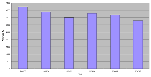
Table 2 below relates to the total volume of reticulated water used in the Shire based on bulk flow meter readings from sources, not property meters. Losses from the reticulated supplies are included in these figures.
| Total reticulated water use | |||
|---|---|---|---|
| 2005-06 | 2006-07 | 2007-08 | 2008-09 |
| 3789ML | 3663ML | 3281ML | 3451ML |
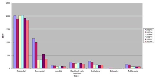
Table 3 below details use by sector based on property meter readings and consequently excludes system losses.
| Sector | 2005-06 | 2006-07 | 2007-08 | 2008-09 |
|---|---|---|---|---|
| Residential | 2026 | 1918 | 1850 | 1999 |
| Commercial | 328 | 538 | 357 | 443 |
| Industrial | 79 | 75 | 65 | 80 |
| Rural Trunk Main customers | 202 | 191 | 162 | 137 |
| Institutions | 135 | 128 | 130 | 127 |
| Bulk sales | 5 | 5 | 3 | 4 |
| Public Parks | 68 | 64 | 65 | 54 |
| Rural / Irrigation | DNR | DNR | DNR | DWE |
Use by sector
Residential use is the largest component of reticulated water use, followed by the commercial sector. A major reduction in commercial water use occurred between the 2002-2003,2003-2004 use at about 1,000 ML/Yr and 2004 onwards when use dropped to 357 ML in 2007-2008. Institutional and parks use also dropped in a similar manner. Residential use in 2007-2008 dropped 9% from a peak in 2005-2006.
Figure 3. Water use by sector
Environmental flows
There is no information available on environmental flows.
Managing water demand and use
Water conservation
Water restrictions were imposed from 2002 onwards in the Tantawanglo/Kiah system. They commenced at Level 1 for 90 days, followed by Level 2 for 107 days. In 2003-2004 Level 2 restrictions applied for 86 days, then for 222 days in 2004-2005. In 2007-2008 Level 1 restrictions were in place for 200 days and Level 2 for 60 days.
No restrictions have been applied in the Bega Tathra system since 2002-2003, when 15 days of Level 3 restrictions were applied. Level 2 restrictions were applied to the Bemboka system in 2002-2003 for 15 days, and in 2003-2004 for 86 days, with none since.
The Brogo/Bermagui system had Level 2 restrictions only in 2002-2003 for 40 days.
In the period 2008-09 there were no days of water restrictions in place for any of the Council's water supplies.
Recycling – making the drop go further
Wastewater reuse is a primary goal of Council’s sewerage operations. Table 4 presents data on water reuse from Council’s 10 sewerage treatement plant. Commisioning of new plants has continued during this period with reuse generally increasing across Cobargo, Candelo, Wolumla and Kalaru. Reuse has also increased significantly at Eden, Bega, Tura Beach and Bermagui. This is also an indicator of the drought conditions that have dominated during the reporting period.
Treated wastewater was extensively used for irrigation of golf courses and other recreational land in the Bega Valley, as shown in the Table 4.
| Sewage Treatment Plant Location | Reuse Strategy | Volume (KL) | |||
|---|---|---|---|---|---|
| 1999-2000 | 2003-04 | 2007-08 | 2008-09 | ||
| Bermagui | Golf Course irrigation | 27520 | 39000 | 26393 | 52069 |
| Bega | Pasture irrigation | 416625 | 164000 | 155750 | 250557 |
| Tathra | Golf Course irrigation | 81422 | 128000 | 156435 | 124025 |
| Tura Beach | Golf Course irrigation | 22000 | 28068 | 42284 | |
| Merimbula | Golf Course irrigation | 116456 | 125000 | 160604 | 167514 |
| Eden | Golf Course irrigation | 81658 | 97000 | 85174 | 96170 |
| Cobargo | Showground irrigation | n/a | n/a | 26375 | 22683 |
| Candelo | Showground irrigation | n/a | n/a | 10666 | 13984 |
| Wolumla | Recreation Reserve & Showground irrigation | n/a | n/a | 18307 | 17767 |
| Kalaru | Racecourse irrigation | n/a | n/a | 1786 | 7545 |
| Total | 723681 | 575000 | 669558 | 794598 | |
Laws and policy
Bega Valley Shire is located entirely within the Southern Rivers Catchment Management Authority region. Effluent reuse agreements are being negotiated for all effluent reuse schemes in the Shire.
Future water supply
Demand for the Tantawangalo Kiah water supply scheme that supplies Wolumla, Candelo, Merimbula ,Tura Beach, Pambula, Pambula Beach, and Eden is currently at or beyond the secure yield of the system.
Demand is increasing and estimated to reach about 3000ML by 2030. In addition the transfer capacity of the sytem between the two sources is limited by the main size between the Kiah borefield and the Tantawangalo Creek.
Augmentation of the supply is needed and is being planned through the proposed Bega – Yellow Pinch Water Transfer Project. This project to improve operational flexibility is aimed at providing a water supply that is less reliant on low flows at the source (improving environmental outcomes), more drought secure, and that will satisfy demand for the 35 year planning scenario for the south of the Shire. At an estimated cost of at a cost of $9.4 million, the Bega to Yellow Pinch Dam pipeline will involve the construction of 21.5 km of 450mm pipeline between Bega borefield and the dam to provide a new source of water in the Kiah-Tantawanglo system and provide a link with the Bega-Tathra system.
Other future projects will include:
- Water treatment at Ben Boyd and Yellow Pinch Dams at a cost of $31.9 million; and South Bega reservoir
- Water filtration for Bermagui/Wallaga Lake, Merimbula/Pambula/Tura Beach and Eden
- Water treatment for Bemboka, Candelo and Wolumla;
- Overall expenditure of $113 million is anticipated over 30 years to ensure that water supply and quality is sufficient for the expanded population of the area.
About the data
Quantitative data were received from the Bega Valley Council. Future projections from Bega Valley Council website.
NGH Environmental (2006, 2009) Proposed Bega – Yellow Pinch Dam Water Transfer Pipeline & Pump Station, Bega, NSW