Bega Valley
Indicator: Ecological Communities
Results for this indicator are also available for [an error occurred while processing this directive]
What the results tell us for Bega Valley Shire
Ninety-one vegetation communities have been recorded within Bega Valley Shire, 19 of which are considered of conservation significance. The Shire also contains occurrences of 13 ecological communities listed as critically endangered or endangered in NSW or nationally, nine of which was gazetted during the current reporting period. Nine wetlands of national importance are also located within the Shire.
It was not possible to accurately assess changes to the extent and condition of native vegetation in the Shire during the current reporting period. No information was available on vegetation cleared. Vegetation in the Shire was affected by fuel reduction burns predominantly in the 2006–07 fire season and by wildfires in the 2006–07 fire season.
No information was available on whether reservation targets for vegetation were met for communities considered to be poorly represented within the broader region's reserve system in the previous reporting period. No information was available on Voluntary Conservation Agreements or wildlife refuges during the current reporting period.
During the current reporting period council worked to help protect conservation values through weed control programs and utilising a guide to protect significant native vegetation along the Shire's roadsides when planning and undertaking road construction and maintenance activities. Council worked with the SRCMA and the local dairy industry in developing, implementing and funding environmental management and improvement initiatives on dairy farms throughout the Shire, particularly with respect to effluent management, riparian zone protection and improvement to dairy laneways.
Vegetation communities in the Shire
Ninety-one vegetation communities (or ecosystems) have been recorded within Bega Valley Shire (see Table 1). These communities were classified as part of two forest Comprehensive Regional Assessment (CRA) programs in south-eastern NSW over 1998 and 1999 (see About the Data) and provide the best coverage and most consistent description of vegetation in the Shire. Miles (2000) provides brief descriptions of many of these communities. These vegetation classifications are still current, however Eden CRA classifications were incorporated (almost unchanged) into the new SCIVI classification system (Tozer et.al 2006), and completely overlap the Eden CRA region. SCIVI has superseded the Southern CRA region, however does not fully encompass the Canberra region, overlapping much of the Southern CRA region, but not extending as far west. SCIVI does not include western vegetation classification types therefore was not applicable to this report.
Eleven of the forest vegetation communities that occur within the Shire were considered vulnerable in 1998 and 1999 (see Table 1), i.e. they were approaching 70% clearance of their pre-1750 extent. In the context of the two CRA regions, an additional 8 communities were still considered poorly represented within those regions' reserve systems in 2004. No information was available on changed status or reservation targets being met for these communities during the current reporting period.
| Forest vegetation communities | CRA Number | Area (ha)# | Vulner- able* |
Poorly Reserved* | ||
|---|---|---|---|---|---|---|
| 2004 | 2000 | 1997 | ||||
| Acacia Scrub | E4 (S35) | 4,030 | ||||
| Basalt Wet Herb Forest | E16 (S55) | 6,310 | ||||
| Bega Dry Grass Forest | E20 | 4,360 | + | + | + | + |
| Bega Wet Shrub Forest | E19 (S48) | 18,130 | + | + | + | + |
| Brogo Wet Vine Forest | E18 | 5,040 | ||||
| Bunga Head Rainforest | E5 | 6 | ||||
| Candelo Dry Grass Forest | E21 | 1,570 | + | + | + | + |
| Coastal Dry Shrub Forest | E49 (S49) | 34,870 | ||||
| Coastal Escarpment and Hinterland Dry Shrub/Fern Forest | S19 | 7,850 | ||||
| Coastal Foothills Dry Shrub Forest | E32 | 23,570 | ||||
| Coastal Gully Shrub Forest | E34 (S18) | 21,680 | ||||
| Coastal Lowland Heath | E55 | 1,550 | ||||
| Coastal Range Dry Shrub Forest | E33 | 15,860 | ||||
| Coastal Scrub and Beach Strand | E61 and E62 (S22 and S23) | 1,240 | ||||
| Coastal Shrub/Grass Dry Forest | S11 | 7 | ||||
| Coastal Warm Temperate RF | E6 | 4,060 | ||||
| Coastal Wet Heath Swamp Forest | S24 | 6 | + | + | + | |
| Cool Temperate Rainforest | E8 | 790 | ||||
| Dry Rainforest | E1 | 60 | ||||
| Dune Dry Shrub Forest | E36 | 620 | ||||
| Eastern Tableland and Escarpment Shrub/Fern Dry Forest | S59 | 120 | ||||
| Eastern Tablelands Acacia/Herb/Grass Forest | S89 | 10 | + | + | ||
| Eastern Tablelands Damp Heath | S69 | 40 | + | + | ||
| Eden Dry Shrub Forest | E47 (S1) | 21,560 | ||||
| Escarpment Dry Grass Forest | E35 (S47) | 24,450 | ||||
| Estuarine Wetland Scrub | E63 | 950 | + | + | + | + |
| Far Southern Coastal Shrub Dry Forest | S8 | 80 | + | + | ||
| Flats Wet Herb Forest | E17 | 2,660 | ||||
| Floodplain Wetlands | E60 | 2,760 | + | + | + | + |
| Foothills Dry Shrub Forest | E44 (S7) | 4,360 | ||||
| Genoa Dry Shrub Forest | E50 | 690 | ||||
| Grey Mangrove | E66 | 60 | + | + | + | |
| High Mountain Wet Layered Forest | E9 | 1,480 | ||||
| Hinterland Dry Grass Forest | E31 | 26,000 | ||||
| Hinterland Heath | E56 | 360 | + | + | + | |
| Hinterland Warm Temperate Rainforest | E7 (S165) | 2,380 | ||||
| Hinterland Wet Fern Forest | E13 | 42,890 | ||||
| Hinterland Wet Shrub Forest | E14 | 25,930 | ||||
| Inland Intermediate Shrub Forest | E42 | 21,240 | ||||
| Kydra Flats Grass Forest | EW4 | 1,300 | ||||
| Lowland Dry Shrub Forest | E46B | 15,390 | ||||
| Lowland Gully Shrub Forest | E37 | 14,590 | ||||
| Lowland Swamp | E57 | 1,560 | ||||
| Monaro Basalt Grass Woodland | E23B | 870 | + | + | + | + |
| Montane Heath | E53 | 210 | ||||
| Mountain Dry Shrub Forest | E45 | 930 | ||||
| Mountain Intermediate Shrub Forest | E41 (S61) | 2,000 | ||||
| Mountain Rock Scrub | E52 | 170 | ||||
| Mountain Sandstone Shrub Forest | E43 | 1,000 | ||||
| Mountain Wet Fern Forest | E12 | 1,857 | ||||
| Mountain Wet Herb Forest | E15 | 18,870 | ||||
| Mountain Wet Layered Forest | E10 | 11,540 | ||||
| Mt Nadgee Heath | E54 | 360 | ||||
| Mumbulla Dry Shrub Forest | E48 | 4,590 | ||||
| Myanba Dry Scrub Forest | E2 | 330 | ||||
| Nalbaugh Dry Grass Forest | E29 | 540 | ||||
| Northern Riparian Scrub | E39 | 410 | + | + | + | |
| Numeralla Dry Shrub Woodland | E22B | 20 | + | + | + | |
| Rhyolite Rock Scrub | E51 | 50 | ||||
| River Mangrove | E65 | 1 | + | + | + | |
| Riverine Forest | E40 (S53) | 300 | + | + | + | |
| Rocky Tops Dry Scrub Forest | E3 | 1,200 | ||||
| Saltmarsh | E64 | 290 | + | + | ||
| Sandstone Dry Shrub Forest | E25 | 110 | ||||
| Seagrass Meadow (Halophila) | E67 | 30 | + | + | + | + |
| Seagrass Meadow (Posidonia) | E68 | 10 | + | + | + | + |
| Seagrass Meadow (Ruppia) | E69 | 30 | + | |||
| Seagrass Meadow (Zostera) | E70 | 110 | + | + | + | + |
| Southern Coastal Hinterland Dry Gully Rainforest | S170 | 970 | + | + | ||
| Southern Coastal Lowlands Shrub/Grass Dry Forest | S10 | 1,520 | + | + | ||
| Southern Escarpment Edge Moist Shrub/Fern Forest | S62 | 680 | ||||
| Southern Escarpment Herb/Grass Dry Forest | S50 | 1,870 | ||||
| Southern Escarpment Shrub/Fern/Herb Moist Forest | S57 | 650 | ||||
| Southern Riparian Scrub | E38 | 380 | ||||
| Sub-Alpine Bog | E59 | 240 | + | + | + | + |
| Subalpine Dry Shrub Forest | E24 | 1,030 | + | + | + | + |
| Swamp Forest | E58 | 810 | ||||
| Tableland and Escarpment Moist Herb/Fern Grass Forest | S56 | 160 | + | + | ||
| Tableland and Escarpment Wet Layered Shrub Forest | S58 | 980 | ||||
| Tableland Dry Shrub Forest | E26 | 10,940 | ||||
| Tantawangalo Wet Shrub Forest | E11 | 780 | ||||
| Timbillica Dry Shrub Forest | E46A | 22,750 | + | + | + | |
| Waalimma Dry Grass Forest | E27 | 1,280 | ||||
| Wadbilliga Dry Shrub Forest | EW1 | 26,410 | ||||
| Wadbilliga Gorge Dry Forest | EW5 (S13) | 8,100 | ||||
| Wadbilliga Heath Forest | EW3 (S135) | 1,080 | ||||
| Wadbilliga Range Shrub Forest | EW2 | 530 | ||||
| Wadbilliga River Valley Forest | EW6 | 1,950 | ||||
| Wallagaraugh Dry Grass Forest | E30 | 420 | ||||
| Wog Wog Dry Grass Forest | E28 | 920 | ||||
CRA Id prefix E = forest ecosystems classified under the Eden CRA; CRA Id prefix S = forest ecosystems classified under the Southern CRA; # Extent in shire at the date of the CRA mapping; For more about extent in shire and definitions of Vulnerable and Poorly Reserved, see About the data; Source: NSW Department of Environment and Climate Change
Endangered ecological communities
Bega Valley Shire contains 13 ecological communities listed as critically endangered or endangered within NSW or nationally (see Table 2). Ten are listed under the NSW Threatened Species Conservation Act 1995, one is listed under the Commonwealth's Environment Protection and Biodiversity Conservation Act 1999. There was a new critically endangered ecological community listing under the Environment Protection and Biodiversity Conservation Act 1999 (EPBC Act) for Littoral Rainforest and Coastal Vine Thickets of Eastern Australia, effective 10 October 2008 (DECC 2008b; DEWHA 2008c). Nine of these ecological communities had final determinations made during the current reporting period. Nine wetlands of national importance are also located within the Shire.
| Name of ecological community | Status | Date of determination* | Recovery Plan |
|---|---|---|---|
| Bangalay sand forest, Sydney Basin and South East Corner bioregions | Endangered in NSW* | Final: 21 October, 2005 | No |
| Brogo wet vine forest in the South East Corner Bioregion | Endangered in NSW* | Final: 17 November 2000 | No |
| Coastal saltmarsh in the NSW North Coast, Sydney Basin and South East Corner bioregions | Endangered in NSW* | Final: 04 June 2004 | No |
| Dry rainforest of the south east forests in the South East Corner Bioregion | Endangered in NSW* | Final: 17 November 2000 | No |
| Freshwater wetlands on coastal floodplains of the NSW North Coast, Sydney Basin and South East Corner bioregions | Endangered in NSW* | Final: 17 December 2004 | No |
| Littoral Rainforest and Coastal Vine Thickets of Eastern Australia | Critically Endangered nationally | Final: 10 October 2008 | No |
| Littoral rainforest in the NSW North Coast, Sydney Basin and South East Corner bioregions | Endangered in NSW* | Final: 04 June 2004 | No |
| Lowland Grassy Woodland in the South East Corner Bioregion (see note) | Endangered in NSW* | Final: 10 August 2007 | No |
| Montane peatlands and swamps of the New England Tableland, NSW North Coast, Sydney Basin, South East Corner, South Eastern Highlands and Australian Alps bioregions | Endangered in NSW* | Final: 17 December 2004 | No |
| River-flat eucalypt forest on coastal floodplains of the NSW North Coast, Sydney Basin and | Endangered in NSW* | Final: 17 December 2004 | No |
| Swamp oak floodplain forest of the NSW North Coast, Sydney Basin and South East Corner bioregions | Endangered in NSW* | Final: 17 December 2004 | No |
| Swamp sclerophyll forest on coastal floodplains of the NSW North Coast, Sydney Basin and South East Corner bioregions | Endangered in NSW* | Final: 17 December 2004 | No |
| Themeda grassland on seacliffs and coastal headlands in the NSW North Coast, Sydney Basin and South East Corner bioregions | Endangered in NSW* | Final: 21 October, 2005 | No |
* Determinations (preliminary and final) under the NSW Threatened Species Conservation Act 1995 made by the NSW Scientific Committee; Source: DECC 2004a–c, 2008a–h
Note: Bega dry grass forest in the South East Corner Bioregion and Candelo dry grass forest in the South East Corner Bioregion, formally considered two separate communities, was combined to form a single name- Lowland Grassy Woodland in the South East Corner Bioregion, on 10 October 2007. As a consequence, reference to Bega Dry Grass Forest in the South East Corner Bioregion and Candelo Dry Grass Forest in the South East Corner Bioregion is omitted from Part 3 of Schedule 1 (endangered ecological community) of the Act (NSW Scientific Committee, 2008).
Other significant communities or habitats
Although not endangered, other vegetation communities in Bega Valley Shire listed as significant (Miles 2000) include the northern riparian scrub and dune dry shrub forest and vegetation occurring on many of the Shire's roadsides (see Miles and Roche 2004).
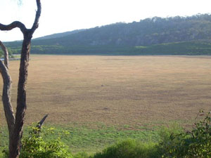
Bondi Lake dried out. Photo: Doug Reckord
No internationally important wetlands (i.e. Ramsar sites) have been declared within the Shire, but nine nationally significant wetlands listed in the Directory of Important Wetlands in Australia (DEHWA 2008a) either occur within or intersect the area.
They are:
- Merimbula Lake—not reserved; surrounding land is urban, rural residential, airstrip and agricultural
- Bondi Lake—reserved; surrounding land is National Park
- Nelson Lagoon—partially reserved; surrounding land is National Park, bushland and agricultural (mixed farming and grazing)
- Pambula Estuarine Wetlands—partially reserved; surrounding land is National Park, bushland, environmental protection, urban, rural residential, agricultural (grazing)
- Twofold Bay—partially reserved; surrounding land is urban, bushland, State Forest and rural
- Wallaga Lake—partially reserved; surrounding land is National Park, bushland, State Forest, urban, rural residential and grazing
- Wallagoot Lagoon (Wallagoot Lake)—partially reserved; surrounding land is National Park, environmental protection, bushland and rural residential
- Nadgee Lake and tributary wetlands—reserved; surrounding land is Nature Reserve
- Bega Swamp—reserved; surrounding land is National Park.
Some environmental features of these wetlands that define their significance include supporting relatively large areas of seagrasses, mangrove and saltmarsh communities, habitat for migratory birds (fauna listed under JAMBA or CAMBA; see About the data), flora of regional significance such as Forest Red Gum (Eucalyptus tereticornis) and Coastal Saltbush (Rhagodia candolleana), and fauna (both terrestrial and marine) considered vulnerable or endangered at a state or national level (DEWHA, 2008a).
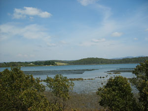
Merimbula Lake mangroves and oysters
One hundred and twenty one SEPP 14 wetlands occur in Bega Valley Shire, the majority being estuarine (DIPNR 2004; Roche 2005). The wetlands and ecosystems of the Shire's estuaries are important for river health and support migrant bird and fish communities.
Vegetation extent and condition
Pressures on vegetation extent
Loss of native vegetation continues to be one of the greatest threats to Australia’s biodiversity. The clearing of native vegetation is a threatening process impacting both ecosystems and species (DEHWA 2006). Even if all clearing were to cease now, the decline in vegetation condition is likely to continue for many years, because of the lag effects of vegetation fragmentation and growing pressure from climate change (DECC 2006). The main responses are the Native Vegetation Act 2003 (and supporting Regulations) and improved compliance monitoring. The new legislative regime is expected to provide a means to address this issue.
Clearing was the main pressure on the extent of native vegetation in Bega Valley Shire during the previous reporting period. Increased fragmentation and clearing have both have been identified as particular threats to the 13 endangered ecological communities occurring in the Shire. No information is available on the extent of native vegetation clearing in Bega Valley Shire during the current reporting period. It appears that the trend in the overall rate of clearing is difficult to accurately assess (see About the data).
Illegal clearing of vegetation
Approximately 41% of the Bega Catchment is composed of rural areas used for agricultural production. The two major land uses are grazing of dairy cattle on lowland foothills and extraction of native forest timber on the steeper uplands and escarpments of the catchment (DIPNR 2008).
No information was available on mapped vegetation change relating to extent of native vegetation in the Shire in the current and previous reporting periods.
Five clearing applications were approved within the Shire during the reporting period under the NSW Native Vegetation Act 2003. They included mainly clearing for domestic powerlines. The total area of vegetation cleared was not available, however a total 43.4 hectares of vegetation was approved for clearing within the Southern Rivers Catchment region, which encompasses Bega Valley Shire, during the reporting period.
Pressures on vegetation condition
The condition of native vegetation is declining over the longer term, particularly due to lag effects from fragmented vegetation remnants. Fire, development pressures, clearing and other processes are all contributing to this decline.
Fire was considered a broad scale pressure on the condition of native vegetation in parts of Bega Valley Shire during the reporting period. Approximately 11,149 hectares of land (about 1.8% of the Shire) was affected by wildfire and prescribed burns in the period 2004–08 (see Table 4). No information is available on the number of forest communities affected by very low severity fires (generally fuel reduction burns) or by fires of unknown severity (generally wildfires).
In the preceding reporting period, approximately 14,300 hectares of land were burnt, with 47 forest communities affected by very low severity fires (generally fuel reduction burns) and 24 communities by fires of unknown severity (generally wildfires).
Other factors such as drought and weed invasion (including the spread of noxious plants such as willows (Salix spp), Bitou Bush (Chrysanthemoides monilifera), Blackberry (Rubus ulmifolius) and the pasture grasses Serrated Tussock (Nassella trichotoma) and African Lovegrass (Eragrostis curvula), also asserted broadscale pressure on vegetation condition within the Shire during the current reporting period.
Environmental weeds are considered a major threat to occurrences of the listed endangered ecological community Lowland Grassy Woodland located in the South East Corner Bioregion in grassy roadside sites. Weeds represent a serious threat to the integrity of these communities, especially when existing as highly fragmented remnant stands. Weeds are considered a general threat to the condition of all 13 endangered ecological communities with occurrences in the Shire. Other general threats to the condition of these communities in the Shire include the following (DECC 2008a; DEWHA 2008b):.
- land degradation and fragmentation of remnants
- grazing and trampling by stock
- erosion and sedimentation
- soil disturbance caused by feral animals
- harvesting of firewood and collection of on-ground woody debris
- high frequency or high intensity fires
- climate change.
Changes to water tables and surface flows caused by drainage works or altered flows in catchments are also general threats to the endangered Montane peatlands and swamps of the New England Tableland, NSW North Coast, Sydney Basin, South East Corner, South Eastern Highlands and Australian Alps bioregions (DECC 2008a).
The main threatening processes identified for nationally important wetlands (Sattler and Creighton 2002) are grazing, feral animals, exotic weeds and changes in hydrological conditions leading to salinisation and other modifications. Grazing and other potentially detrimental activities continue in sensitive areas such as SEPP14 wetlands of the Bega River estuary. The location of many of these wetlands in estuarine areas also places them in close proximity to sites for possible future development (DIPNR 2004).
Conservation and management
Law and policy
Some national and state laws require recovery or action plans to be prepared for endangered ecological communities, and for the presence of such communities to be taken into account during decision-making on developments applications. These laws also aim to minimise the effects of threatening processes on endangered ecological communities or prevent communities from becoming endangered. Laws such as the Native Vegetation Act 2003 (enacted during the previous reporting period and replacing the Native Vegetation Conservation Act 1997), also aim to minimise the effects of threatening processes and to protect, conserve and improve the condition of existing native vegetation, particularly at a local and regional level (see Government laws and policies).
Bega Valley Shire is located within the Southern Rivers Catchment Management Authority (CMA) area established under the NSW Catchment Management Authorities Act 2003. Each CMA is required to work in partnership with Local Government as well as other stakeholders and must develop and administer a regional vegetation management plan. These plans and the catchment blueprints prepared by the catchment management boards which preceded the CMAs, also support the conservation of native ecosystems. The South East Catchment Blueprint (South East Catchment Management Board 2002), completed during the current reporting period, includes a range of management actions to restore, maintain or conserve biodiversity values in the catchment area.
Local Government legislation, regulations and planning documents such as Local Environment Plans (LEPs) may also provide some protection for ecological communities, by limiting or prohibiting certain activities that may lead to the further decline of endangered ecological communities.
Current land zoning in Bega Valley Shire provides minimal protection for wetlands and other significant ecosystems and many important areas are not well protected. To help address this issue, a new initiative was established under the Integrated Bega River Health Package, which aims to fence and manage 100 wetlands on farmland for conservation values (DIPNR 2004). Studies on the Bega River Estuary (DIPNR 2004) the draft Bega River Estuary Management Plan (2008) and Merimbula Estuary (NGH Environmental 2003) also provide planning frameworks and management options for these estuaries in the Shire.
Conservation reserves
Seventeen national parks, nature reserves and state conservation areas either fall within or intersect Bega Valley Shire, covering approximately 250,200 hectares or 40% of the Shire area.
Additions totalling 53.5 hectares were made to three reserves within the current reporting period, compared with additions totalling approximately 4,800 hectares made to five reserves in the previous period. No new conservation reserves were gazetted in the current reporting period, compared with three new conservation reserves totalling about 10,500 hectares gazetted in the Shire during the previous period. Many of these additions to the reserve network during the previous reporting period were outcomes of the Southern and Eden Regional Forest Agreements.
No information was available on forest communities which were considered poorly represented within the regional reserve system in 2004 meeting regional reservation targets during the current reporting period. No information was available on forest communities still classed as vulnerable changing their status due to new reserves or additions to the regional reserve system within the current reporting period.
| Conservation Reserve | Gazettal Type#. | Area (ha) | No of significant communities+ | |
|---|---|---|---|---|
| Vulnerable | Poorly Reserved | |||
| South East Forest National Park | Additions | 1 | 1 | 1 |
| Bournda National Park | Additions | 12.50 | ||
| Ben Boyd National Park | Additions | 40.00 | ||
Source: Department of Environment and Climate Change
Nine conservation reserves within the Shire had formal plans of management in place (see Table 4 ).
| Reserve | Date plan adopted |
|---|---|
| Ben Boyd National Park | 2000 |
| Bermaguee Nature Reserve | November 1999 |
| Bournda National Park and Nature Reserve | January 2000 |
| Davidson Whaling Station Historic Site | June 1995 |
| Eagles Claw Nature Reserve | July 1992 |
| Gulaga National Park | November 1999 |
| Mimosa Rocks National Park | December 1998 |
| Mount Imlay National Park | October 1998 |
| Nadgee Nature Reserve | June 2003 |
Source: Department of Environment and Climate Change
Draft fire management strategies were developed for Mount Imlay National Park (also covers South East Forest National Park, Egan Peaks Nature Reserve and Yurammie State Conservation Area) and Nadgee Nature Reserve. Fire management plans have been prepared and adopted for Ben Boyd National Park, Bournda National Park and Nature Reserve and Mimosa Rocks National Park.
Other conservation management
There have been gains in terms of Noxious Weed Management following the restructure, especially in regard to the streamlining of involvement in corporate planning activities and the provision of comment regarding development proposals. There is now increased opportunity for weed management to become a component of vegetation management across Council functions and further efficiencies will flow as the functions become better integrated. Further cuts in the amount of real funding for noxious weeds management available from the Government will mean that such integration will become more even more important if service level is to be maintained.
Already in 2005/2006 noxious weed management was underpinned by contributions of in excess of $45,000.00 from the Environmental levy, an amount that is likely to continue into future years. Estuary management grants were also successfully obtained during the period at a much higher level than in previous years. A condition of the awarding of these grants saw the wrap up of a number of small outstanding estuary management grants from previous years. This has been another benefit of the restructure that now sees all Council’s environmental management within the one functional area.
Council’s Rangers work with the community and the (NP&WS) regarding threatened wading birds and received the 2005/2006 NSW Rangers Institute Award for Innovation in Companion Animal Management in recognition of this work. This project has continued through this reporting period.
Outcomes
- Integration of the Noxious Weeds Team with the Environmental Services Section completing Council’s 2004 restructure,
- The granting of the Defeating the Weeds Menace Grant of $210,000.00 (Stage 1) for collaborative weed management work with landholders in the Genoa catchment.
- The successful awarding of significant Estuary Management grants for improvements at Wonboyn, Merimbula, Bermagui and Mogareeka.
- The review of the Tree Preservation Order (after 10 years) and the development of the draft Vegetation Management Code that will see Council well placed for the recent legislative and for the changes that will be introduced in 2008 /2009 with the new LEP.
- The negotiation of the funding contract for the continuation of the Vegetation Recovery Project was accomplished ensuring funding for the project through until 30 June 2009
- A Memorandum of Understanding negotiated with the Southern Rivers CMA detailing information sharing and communication channels to ensure a more efficient implementation of the native vegetation legislation. This will have a positive impact on development assessment and native vegetation management.
- Success with the Southern Councils Group in securing funding for 3 years through the DECC Urban Sustainability program for project works aimed at improving environmental management for commercial businesses in the region.
- Work with the SRCMA and the local dairy industry in developing, implementing and funding environmental management and improvement initiatives on dairy farms throughout the Shire particularly with respect to effluent management, riparian zone protection and improvement to dairy laneways.
No information was available on the number of privately owned properties in the Shire with a Voluntary Conservation Agreement (VCA) in place. Information on the vegetation communities occurring within these VCAs and wildlife refuges is held by DECC along with copies of plans of management or schemes of operation developed and/or implemented for them.
The Bega Valley Conservation Management Network was established in 2006 (through SRCMA funding) and aims to promote the conservation of particular ecosystems, such as grasslands and woodlands, and to facilitate collaborative conservation efforts between land managers of differing tenure.
Twenty-six Landcare groups operate within Bega Valley Shire; some may also be Coastcare groups. For information on the range of activities occurring in the Shire and in the Southern Rivers catchment, see the Landcare NSW website.
Community groups, council and/or other organisations may have undertaken various projects during the reporting period that enhanced the protection of ecological communities in the Shire. No information was available on these projects.
About the data
The information in the report is provided by Bega Valley Shire Council unless shown otherwise.
Forest vegetation communities referred to in this report were derived from the Southern Comprehensive Regional Assessment (CRA) forest ecosystem mapping, undertaken in 1999. All calculations are based on the extant and pre-1750 forest ecosystem layers. The extant forest ecosystem layers reflect the extent of these vegetation communities at the time of mapping.
Under the CRA mapping, a ‘vulnerable’ vegetation community was defined as one whose areal extent at the time of mapping was approaching 70% loss of its pre-European extent. A vegetation community was defined as ‘poorly reserved’ when less than 15% of its pre-European extent was located in formal conservation reserves across the CRA region. Further information on the 70% clearing threshold and the 15% reservation threshold is provided in JANIS (1997).
The CRA mapping was used for this report because two CRAs , Eden (mapping carried out in 1998) and Southern, provided the most current data which covered the entire extent of the majority of local government areas in the Australian Capital Region. However the mapping data have the following limitations:
- some mapped CRA ecosystem types may be inconsistent with vegetation on the ground because the CRA vegetation types were modelled and limited ground truthing was undertaken in some areas
- the vegetation classifications were focussed primarily of forest vegetation types and may poorly reflect non-forest communities
- the vegetation classifications used to describe forest ecosystems were not a widely used system
- the vegetation classification systems used in the Eden and Southern CRAs differ and there may be some duplication of forest types at the borders of these two study areas.
No data were available regarding extant vegetation at 30 June 2008, and hence it was not possible to determine changes in the extent of forest communities within the council area during the current reporting period. Overall vegetation condition assessment across the landscape is very difficult to achieve. Remote sensing below the canopy level is still not possible given current technology and cost requirement in achieving statistically significant results from survey and the complexities of obtaining permission to enter private land for survey staff.
Mapping of the amount of vegetation cleared was not available at a scale suitable for application within LGA’s boundaries, and reflects significant limitations in accurately assessing this indicator. Broadscale analyses under-estimate the overall rate of clearing because current techniques only operate under large map scales. Effectively this means that it only records removal of woody vegetation that is at least two metres tall with a canopy cover of 15% or more, excluding changes in sparse open woodlands and grasslands, which are extensive and among the most affected vegetation types in NSW.
Fine-scale remote-sensing studies allow a more accurate appraisal of clearing rates in woodlands, open woodlands and shrublands, however coverage is limited to particular regions of NSW. Authors using these methods in the NSW State of the Environment Report 2006 indicate that clearing rates are substantially greater (8–10 times higher) than the estimates obtained from the coarse-scale analyses referred to above. However, being regional, they provide an incomplete view of state wide clearing. The availability of accurate vegetation clearing data is of critical importance for future reporting purposes, due to the threat that this pressure represents to biodiversity.
Data on vegetation approved for clearing within Catchment Management Association regions under the NSW Native Vegetation Act 2003 was accessed through the DECC website under the Public register of approved clearing PVPs and development applications. Geographic analysis would reveal locations within LGA boundaries, however this was unavailable during the reporting period. The data collection system was changed in 2006 with the introduction of the new regulations. These estimates exclude the area of vegetation cleared illegally and clearing carried out legally under statutory exemptions (in 2005, 40% of all clearing was estimated to be illegal in NSW (Audit Office 2006)).
Threats to each endangered ecological community was provided by DECC, under the NSW Scientific Committee - final determination page, and/or the Threatened Species, Populations and Ecological Communities endangered ecological communities profile page. The information contained in this database is available on the internet link under DECC 2008a in the references. New parks and additions to existing reserves was provided by DECC upon request, as the website only listed all the parks and reserves created over the last 12 months. Information on park and fire management plans, as well as recovery plans for endangered ecological communities was provided by DECC
CAMBA = China-Australia Migratory Bird Agreements
JAMBA = Japan-Australia Migratory Bird Agreements
References
Audit Office 2006, Auditor-General's Report: Performance Audit, Department of Natural Resources – Regulating the Clearing of Native Vegetation, follow-up of 2002 performance audit, Audit Office of NSW, Sydney
DECC—see Department of Environment and Climate Climate Change (NSW)
DEHWA—see Department of Environment, Water, Heritage and the Arts (Commonwealth)
Department of Environment and Climate Change (NSW) (2008a) NSW Scientific Committee—Final Determination, (search on threatened ecological community - endangered ecological community listing), viewed 20 October 2008, http://www.environment.nsw.gov.au/natureconservation.htm
Department of Environment and Climate Change (NSW) (2008b) Threatened Species, Populations and Ecological Communities, Final determinations by date, viewed 22 October 2008, http://www.environment.nsw.gov.au/committee/FinalDeterminations.htm
Department of Environment and Climate Change (NSW) (2006) NSW State of the Environment Report 2006, Biodiversity http://www.environment.nsw.gov.au/soe/soe2006/chapter6/chp_6.1.htm#6.1.60
Department of Environment, Water, Heritage and the Arts (Commonwealth) (2006) Australia State of the Environment 2006, Pressures on biodiversity http://www.environment.gov.au/soe/2006/publications/report/biodiversity-2.html
Department of Environment, Water, Heritage and the Arts (Commonwealth) (2008a) Australian Wetlands Database, Department of Environment and Heritage, viewed 22 October 2008, http://www.environment.gov.au/cgi-bin/wetlands/search.pl?smode=BOTH
Department of Environment, Water, Heritage and the Arts (Commonwealth) (2008b) Biodiversity, search on threatened ecological community, viewed October 2008, http://www.environment.gov.au/biodiversity/index.html
Department of Environment, Water, Heritage and the Arts (Commonwealth) (2008c) EPBC Act List of Threatened Ecological Communities, Final determinations by date, viewed October 2008, http://www.environment.gov.au/biodiversity/index.html
Department of Infrastructure, Planning and Natural Resources (NSW) (2004) Bega River Estuary Data Review – Final Report, January 2004, NSW Department of Infrastructure, Planning and Natural Resources, Wollongong.
Department of Infrastructure, Planning and Natural Resources (NSW) (2004a) 2003/04 Combined NSW Catchment Management Authorities Annual Report, Volume 1: CMA Activities and Achievements, Department of Infrastructure, Planning and Natural Resources, Sydney.
DIPNR—see Department of Infrastructure, Planning and Natural Resources (NSW)
Gellie, NJH (2005) Native Vegetation of the Southern Forests: South-East Highlands, Australian Alps, South-west Slopes, and SE Corner Bioregions. Cunninghamia, 9(2), in press.
JANIS—see Joint ANZECC/MCFFA National Forest Policy Statement Implementation Sub-committee
Joint ANZECC/MCFFA National Forest Policy Statement Implementation Sub-committee (1997) Nationally Agreed Criteria for the Establishment of a Comprehensive, Adequate and Representative Reserve System for Forests in Australia, Joint ANZECC/MCFFA National Forest Policy Statement Implementation Sub-committee, Commonwealth of Australia.
Miles, J (2000) State of the Vegetation Report for the Bega Valley Shire, prepared for the Bega Valley Shire Council and the Far South Coast Catchment Management Committee, Bega Valley Shire Council, Bega, viewed 19 October 2008, http://www.begavalley.nsw.gov.au/Environment/vegetation/vegetation.htm.
Miles, J and Roche, G (2004) Guide to the management of roadside sites with significant native vegetation, Bega Valley Shire Council, Bega, viewed 19 October 2008, http://www.begavalley.nsw.gov.au/Environment/Environment _Reports/roadside/BVSC%20A5%20Guide%20-%20WEB.pdf.
NGH Environmental (2003) DRAFT Merimbula Estuary Management – Natural Resources Inventory, prepared by NGH Environmental for Bega Valley Shire Council.
Sattler, P and Creighton, C (Eds) (2002) Australian Terrestrial Biodiversity Assessment 2002, National Land and Water Resources Audit on behalf of the Commonwealth of Australia, Chapter 4: Threatened Ecosystems and Species, viewed 19 October 2008, http://audit.deh.gov.au/ANRA/vegetation/docs/biodiversity/bio_assess_threat.cfm.
South East Catchment Management Board (2002) South East Catchment Blueprint – An Integrated Catchment Management Plan for the South East Catchment 2002, NSW Department of Land and Water Conservation, Sydney, viewed 19 October 2008, http://www.dlwc.nsw.gov.au/care/cmb/blueprints/pdf/south_east_blueprint.pdf.
Tozer, M.G., Turner, K., Simpson, C., Keith, D.A., Beukers, P., MacKenzie, B., Tindall, D. & Pennay, C. (2006) Native vegetation of southeast NSW: a revised classification and map for the coast and eastern tablelands. Version 1.0. Department of Environment and Conservation and Department of Natural Resources