Young
Indicator: Land Use
Results for this indicator are also available for [an error occurred while processing this directive]
What the results tell us for Young
Maps of land use in | 1997 | 2000 | 2004 | 2008 (see below)
There have been no major landuse changes reported in Young Shire in the current reporting period. As in 2004, the main landuse in Young Shire in 2008 remains agriculture, which made up 91% of the total shire area. Conservation and bushland were the next most significant landuses, comprising some 4% and 3% of the shire respectively.
How is the land being used now?
Of the total shire area (269,370 hectares), the dominant landuse at the end of the current reporting period was agriculture (91%) (see Figure 1). Young township, which covered 2% of the total shire area, comprised the majority of urban land. There has been no change reported from 2004.
Figure 1. Major landuse in Young Shire, June 2008*
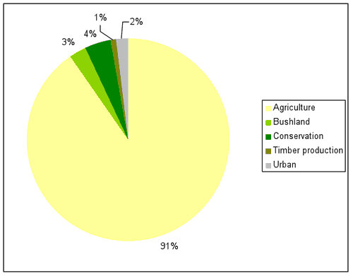
Source: Young Shire Council; *some landuse categories are too small to appear in the above figure
What has changed and why?
There have been no significant reported changes in landuse within the shire between 1997 and 2008 (see Table 1). No reported changes have occurred within the Shire over the current period.
| Landuse Category | 1997 | 2000 | 2004 | 2008 |
|---|---|---|---|---|
| Agriculture | 91% | 91% | 91% | 91% |
| Bushland | 3% | 3% | 3% | 3% |
| Conservation | 4% | 4% | 4% | 4% |
| Quaries | 0.04% | 0.04% | 0.04% | 0.04% |
| Timber production | 0.9% | 0.9% | 0.9% | 0.9% |
| Urban | 2% | 2% | 2% | 2% |
| Waterbodies | 0.09% | 0.07% | 0.09% | 0.09% |
Source: Young Shire Council
Agriculture
The total amount of land under agricultural production in the Shire remained constant in the current reporting period (see Table 1). There has also been no reported change in the use of land under agricultural production in the current reporting period.
As reported in 2004, the area of agricultural land used for grazing and cropping within the Shire has fluctuated since 1997, while mixed farming has declined steadily over the same period. This change is reflected in the national figures overall, where larger holdings are getting larger and are tending towards specialisation, thereby decreasing the traditional family mixed farming enterprises and consolidating the ownership of the holdings.
Intensive agriculture consisting of piggeries and chickens has steadily increased in recent times within the shire and is now a large contributor to the economy of the district through both employment and direct income.
Timber production
The areas under timber production within the Shire (State Forest and private softwood plantations) remained unchanged during the current reporting period.
Bushland
The total area bushland within the shire has remained unchanged from the 2004 reporting period.
Conservation
The area of land under conservation remained unchanged in the current reporting period. As reported in 2004, one new nature reserve was dedicated within the shire during the previous reporting period, namely Koorawatha Nature Reserve (670 hectares) and 500 hectares were added to the existing Dananbilla Nature Reserve.
Future planning
As reported in 2004, there was an amalgamation of local government areas within NSW during the previous reporting period. As reported in the 2005-06 Annual Report, Young Shire Council is conducting a strategic review of the Shire as a whole and in the process of developing a Local Environmental Plan.
About the data
The landuse maps and statistics reported in this section are based on data from NSW State Governement agencies, Councils and satellite images. The primary purpose of the mapping was to assess trends in landuse change and not to provide an accurate account of the actual areas changed.
Young Shire Council provided Local Environmental Plan and cadastral data. In general the data provided by council and State Government departments showed a higher level of detail than satellite classifications. Therefore, these layers were usually used as the primary source of data and supplemented by satellite imagery (Landsat data and SPOT VI data) as needed (mostly for agricultural landuses and bushland).
All landuse maps for Young Shire were provided to council for checking and correction, particularly for 2004 and 2000.
All percentages shown in this indicator are a percentage of the shire and not a percentage of the landuse type. The areal extents of the various landuse types (hectares) were calculated from data that had been adjusted (normalised) to take account of (usually minor) differences between the size of Young Shire as gazetted by council, and the size calculated from spatial data.
