Harden
Indicator: Land Use
Results for this indicator are also available for [an error occurred while processing this directive]
What the results tell us for Harden
Maps of land use in | 1997 | 2000 | 2004 | 2008 (see below)
There have been no major landuse changes reported in Harden Shire in the current reporting period. As in 2004, the main landuse in Harden Shire in the current reporting period was agriculture, which made up 96% of the total Shire area. Urban comprised 2% of the total Shire area, while bushland and waterbodies each comprised 1% of the total Shire area.
How is the land being used now?
Of the total Shire area (186,900 hectares), the dominant landuse at the end of the current reporting period was agriculture (96%) (see Figure 1). The township of Harden and the villages of Jugiong, Wombat, Kingsvale and Galong comprised the majority of the urban land, which covered only 2% of the total area.
Figure 1: Major landuse in Harden Shire, June 2008
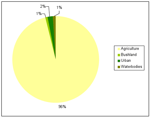
Source: Harden Shire Council 2008
What has changed and why?
There has been no major landuse change in the Shire from 1997 to 2008 (between the end of the current and last three reporting periods). The area used for each of the major landuses—agriculture (96%), bushland (1%), urban (2%), and waterbodies (1%)—was generally the same across all four reporting periods. These correspond to the areas shown in the graph in Figure 1.
Agriculture
As reported above, the amount of land in the Shire under agricultural production has remained relatively stable since 1997.
While there is currently no available data regarding changes to agricultural land usage in the current reporting period, during the previous reporting period cropping increased by 22,700 hectares and replaced grazing and mixed farming (Figure 2). It is possible that some of this change may have been the result of drought conditions. The 2002–03 drought was the third driest year since 1882.
As reported in the 2004 period, the area of agricultural land used for grazing (including sheep and cattle) has fluctuated since 1997, while cropping has undergone a steady increase and mixed farming a steady decrease over the same period (see Figure 2). Cropping within the Shire is predominantly for wheat and canola.
Figure 2: Agricultural landuse subcategories in Harden Shire in 1997, 2000 and 2004
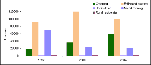
Source: see About the data
Timber production
There are no state owned forests within the Shire used for timber production. There has been no report of new plantation areas being developed in the current reporting period.
Bushland
As reported above, the area of bushland within the Shire has remained stable since 1997.
Conservation
No formal conservation reserves occur within Harden Shire. Although eight wildlife refuges are present, together covering about 6,100 hectares, they are mapped as a variety of landuses including bushland, grazing, cropping and mixed farming.
Other
As noted in the 2004 reporting period, Council developed a regional strategic plan in 2001 which identified a need for further housing development within the Harden–Murrumburrah townships. Ten lots were released, and nine developed within the current reporting period. Over that time, Council purchased land from the Anglican Church to be set aside for future residential developments in the Harden—Murrumburrah area.
Council is currently undertaking a conversion Local Environmental Plan (LEP) to recognize existing land uses and zone them according to the State LEP Standard Instrument.
During the previous reporting period Shire Council approved the expansion of a limestone mine at Galong.
Future planning
Harden Shire Council has been in the process of developing a new LEP during the current reporting cycle. Council has gained support from the Department of Planning to undertake a minor ‘spot rezonings’ within the Shire to develop further residential subdivisions. This rezoning consists of 13 residential allotments.
About the data
The landuse map and statistics reported in this section are based on the data from NSW State Government agencies, Council and satellite images. The primary purpose of the mapping was to assess trends in landuse change and not to provide an accurate account of the actual areas changed.
In general, the data provided by Council and State Government departments showed a higher level of detail than satellite classifications. Therefore, these layers were usually used as the primary source of data and supplemented by satellite imagery (Landsat data and SPOT VI data) as needed (mostly for agricultural landuses and bushland).
All landuse maps for Harden Shire were provided to Council for checking and correction, particularly for 2004 and 2000.
All percentages shown in this indicator are a percentage of the Shire and not a percentage of the landuse type. The areal extents of the various landuse types (hectares) were calculated from data that had been adjusted (normalised) to take account of (usually minor) differences between the size of Harden Shire as gazetted by Council, and the size calculated from spatial data.
