Goulburn-Mulwaree
Indicator: Land Use
Results for this indicator are also available for [an error occurred while processing this directive]
What the results tell us for Goulburn Mulwaree
Maps of land use in | 1997 | 2000 | 2004 | 2008 (see below)
At the time of reporting, there was no new landuse data available for the Goulburn Mulwaree Council area other than that used for the 2004 Regional State of the Environment report (RSoER). No major landuse changes have been reported by the Goulburn Mulwaree Council.
In 2004, the main landuse in Goulburn Mulwaree Council area was agriculture, which made up 55% of the total Council area. The other major landuses were bushland and conservation, comprising approximately 34% and 7% of the Council area respectively.
How is the land being used now?
As reported in the 2004, of the total Council area (323,179 hectares), the dominant landuses at the end of the previous reporting period were agriculture (55%), bushland (34%) and conservation (7%) (see Figure 1). Goulburn township and Marulan, Tarago, Lake Bathurst, Bungonia and Tallong villages comprised the majority of urban land, which covered only 2% of the total Council area.
Figure 1. Major landuse in Goulburn Mulwaree Council area, June 2004
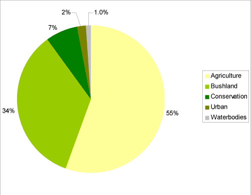
Source: Goulburn Mulwaree State of the Environment Report 2004
What has changed and why?
In 2004, the RSoER reported that no broadscale changes in landuse had occurred within the Council area since 1997 (see Table 1). With no available landuse data for the current reporting period, it is unknown whether there have been major landuse changes since the 2004 RSoER.
| Landuse Category | 1997 | 2000 | 2004 |
|---|---|---|---|
| Agriculture | 55% | 55% | 55% |
| Bushland | 36% | 36% | 34% |
| Conservation | 5% | 5% | 7% |
| Quarries | 0.3% | 0.3% | 0.3% |
| Timber production | 0.4% | 0.4% | 0.4% |
| Urban | 2% | 2% | 2% |
| Waterbodies | 1% | 1% | 1% |
Source: Goulburn Mulwaree State of the Environment Report 2004
Agriculture
No current agriculture landuse data was available for the Council area for the 2008 reporting period. In 2004, it was reported that the total amount of land under agricultural production in the Council had remained relatively stable since 1997 (see Table 1).
Timber production
No current timber landuse data was available for Goulburn Mulwaree Council area for the 2008 reporting period. The total amount of land under timber production in the Council area has remained relatively stable since 1997 (see Table 1).
Bushland
No current landuse data relating to bushland was available for Goulburn Mulwaree Council area for the 2008 reporting period.
In 2004, the area of bushland in the Council area appeared to decrease by approximately 5,000 hectares during the previous reporting period, after remaining relatively stable between 1997 and 2000. However this decrease was predominantly due to bushland areas being dedicated within reserves (see Conservation), and thus being mapped as conservation rather than as bushland in 2004, and does not reflect an actual decrease in bushland on the ground.
Conservation
No current landuse data relating to conservation was available for Goulburn Mulwaree Council area for the current reporting period.
In 2004, the area of land under conservation increased by approximately 5,000 hectares, primarily due to the conversion of about 3,900 hectares of freehold land and the transfer of about 1100 hectares of Crown land. The majority of Crown lands (about 1070 hectares) were transferred under the Southern Regional Forests Agreement to help develop a comprehensive, adequate and representative reserve system to protect forest ecosystems and conserve biodiversity.
Two new nature reserves (Jerralong and Nadgigomar) were created within the Council area through normal reserve acquisitions during the previous reporting period. Additions to existing reserves included Morton National Park.
Future planning
Council is in the process of developing a new Local Environmental Plan (LEP) and Strategy Plan. The LEP provides statutory information about land use, including specific objectives and zoning information. The Strategy Plan 2020 will provide detailed guidance about the future direction of the area over the next 15 years. The project to date has involved community consultation, data gathering and discussion of land use issues such as water supply, industrial development, rural land use, new farming practices, population changes and job opportunities.
About the data
Goulburn Mulwaree Council provided cadastral data and LEP information. In general the data provided by Council and State Government departments showed a higher level of detail than satellite classifications. Therefore, these layers were usually used as the primary source of data and supplemented by satellite imagery (Landsat data and SPOT VI data) as needed (mostly for agricultural landuses and bushland).
All landuse maps for Goulburn Mulwaree Council area were provided to Council for checking and correction, particularly for 2004 and 2000.
All percentages shown in this indicator are a percentage of the Council area and not a percentage of the landuse type. The areal extents of the various landuse types (hectares) were calculated from data that had been adjusted (normalised) to take account of (usually minor) differences between the size of Goulburn Mulwaree Council area as gazetted by Council, and the size calculated from spatial data.