Bega Valley
Indicator: Surface Water Quality
Results for this indicator are also available for [an error occurred while processing this directive]
What the results tell us for Bega Valley
Bega Valley Shire features two catchments, Bega River catchment and Towamba River catchment, both of which are in the Southern Rivers Catchment Management Authority.
The Bega River Catchment has an approximate area of 2,950 km2 with several rivers including Brogo River, Bemboka River, Narira Creek, Murrah River and Bega River.
The Towamba River catchment has an approximate area of 2,200 km2. The most significant rivers in the catchment are the Pambula and Womboyn Rivers.
Bega Valley’s surface water is generally of a good quality as approximately 70% of the Shire is covered by native forest, mostly in state forests and national parks or other conservation reserves.
Three key determinants of surface water quality are electrical conductivity, total phosphorus and turbidity levels. Three sites in Bega Valley Shire are assessed for thier surface water quality.
Trends in surface water quality
Bega Valley Shire has surface water quality monitoring in three locations:
- Brogo River at Angledale (site number 219025)
- Bemboka River at Morans Crossing (site number 219003)
- Towamba River at Towamba (site number 220004).
| Parameter* and location | Median values | Default trigger values ** | ||
|---|---|---|---|---|
| 1997–2000 | 2000–04 | 2004-08 | ||
| Brogo River at Angledale (219025) | ||||
| Electrical conductivity (µS/cm) | 120 | 122 | 102 | 350 |
| Total phosphorus (µg/L) | 15 | 17 | 16 | 20 |
| Turbidity (NTU) | 2 | 2 | 2 | 25 |
| Bemboka River at Morans Crossing (219003) | ||||
| Electrical conductivity (µS/cm) | 136 | 138 | 169 | 350 |
| Total phosphorus (µg/L) | 20 | 18 | 19 | 20 |
| Turbidity (NTU) | 2 | 2 | 2 | 25 |
| Towamba River at Towamba (220004) | ||||
| Electrical conductivity (µS/cm) | 193 | 189 | 219 | 350 |
| Total phosphorus (µg/L) | 5 | 9 | 8 | 20 |
| Turbidity (NTU) | 1 | 2 | 2 | 25 |
* µS/cm = microsiemens per centimetre; µg/L = microgram per litre; NTU = nephelometric turbidity unit; ** For information on default trigger values, see About the Data
Source: NSW Provisional River Data, 2008
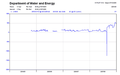
Figure 1. Electrical Conductivity for Brogo River at Angledale, 2004-08
Source: NSW Provisional River Data, 2008
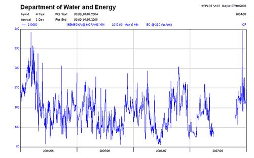
Figure 2. Electrical Conductivity for Bemboka River at Morans Crossing, 2004-08
Source: NSW Provisional River Data, 2008
Brogo River at Angledale
The median value for electrical conductivity decreases over the current reporting period, when compared to the previous reports (Table 1). The electrical conductivity was relatively stable between 2004 and 2008, with the exception of one recorded value in 2007-2008, which appears to be an error (Figure 1). Turbidity exceedence and total phosphorus exceedance are rated as fair at this site, by the Australian Natural Resources Atlas, and remained relatively constant over the reporting period.
Bemboka River at Morans Crossing
The electrical conductivity had many small variations over the current reporting period, as shown in Figure 2. However, the medium electrical conductivity still increased, when compared to the pervious reporting periods. Electrical conductivity, however, was still well under the default trigger value.
Turbidity exceedence and the total phosphorus exceedance are rated as fair at this site, by the Australian Natural Resources Atlas. These values remained relatively constant over the reporting period.
Towamba River at Towamba
Electrical conductivity for the site at Towamba was not available for the reporting period on the New South Wales (NSW) Natural Resources Atlas, however, periodic reporting information by NSW Department of Water and Energy showed the electrical conductivity increased in the current reporting period, when compared to the previous reporting periods. This increase however is still significantly under the default trigger value. The salinity exceedence is rated as good by the Australian Natural Resources Atlas. Turbidity exceedence and the total phosphorus exceedance are also rated by the Australian Natural Resources Atlas, both of these measures are rated as fair, and remained relatively constant over the reporting period.
Other studies
Bega Valley Shire Council monitors water pollution for the tourist beaches of Eden, Pambula, Merimbula, Tathra and Bermagui. The beaches where Shire Council has ocean outfalls in Bega Valley, also have monitoring attached to the approval for the discharge of treated sewage by the NSW Department of Environment and Climate Change (ie through the sewage treatment plant licence conditions). These beaches are: Beares Beach in Bermagui, Main Beach in Merimbula and at the southern end of Aslings Beach in Eden.
Bega Valley Shire Council has also participated in the South East Water Quality Monitoring Project with the Southern Region Catchment Management Authority, NSW Department of Environment and Climate Change and Eurobodalla Shire Council. This project concluded during this reporting period. Two of the major objectives of the program are to: establish what is known about local water quality; and assess the adequacy of existing monitoring programs of the South East. The project concluded during early 2006 and developed the following key outcomes:
- Water Quality Data Collection and Management Protocols (WBM 2005)
- (Historic) Water Quality Database
- Water Quality Monitoring Interpretation Reports for Upper Catchments and Source Waters, Bega / Brogo River Swimming Study, Coastal Lakes and Intermittently Closing and Opening Lake and Lagoon Systems (ICOLLs) Project, Bega Estuary Monitoring, and the Bega Valley Shire Rainfall Event.
This project also produced a key outcome in making specific recommendations regarding for future water quality monitoring. This recommendation has been curtailed by resource issues but will be examined in greater detail during the 2009 2010 management plan development. The South East Water Quality Monitoring Project was funded through the Natural Heritage Trust and was a project based on partnerships developed between the various stakeholders and funded by Waterwatch Australia.
Council also undertakes additional water quality monitoring including:
- A summertime ‘Beachwatch’ water quality sampling program 20 sites consisting of beaches and estuarine lake. This program report weekly in the local media.
- Sporadic fresh water sampling which is conducted when issues arise or as potential problems are identified.
About the data
Data for the monitoring sites covered in this report were from the NSW Department of Water and Energy (DWE) http://www.dwe.nsw.gov.au/
Data is routinely reported at http://nratlas.nsw.gov.au. DWE is responsible for quality control and on-going maintenance of the data collected in its databases.
Monitoring as part of the NSW Department of Environment and Climate Change licensing requirements for sewerage treatment plants is undertaken at beaches where Shire Council has ocean outfalls approved for the discharge of treated wastewater. This information is reported annually to DECC.
Interpreting the data
Default environmental value
The Water Quality and River Flow Interim Environmental Objectives (EPA 1999) for NSW, which are still current, indicate that protection of aquatic ecosystems is the default environmental value for most water bodies in catchments associated with Boorowa Shire. Although individual Shire Councils are free to assign additional or different value through local processes and based on site-specific information, so far no Shire Councils in the Australian Capital Region have done so.
Default trigger values
The default trigger values used in this report were those values set out in Australian and New Zealand Environment and Conservation Shire Council (ANZECC) and Agriculture and Resource Management Shire Council of Australia and New Zealand (ARMCANZ) (2001). The values applicable to the Australian Capital Region are those for "south-east Australia for slightly disturbed ecosystems" (ANZECC and ARMCANZ 2001). The default trigger values for different water quality parameters for the protection of aquatic ecosystems are based on the type of water body in question. Compared to most other environmental objectives, the protection of aquatic ecosystems is one that requires more stringent water quality guidelines.
The median value (i.e. middle value of a data series) for each monitoring site in the shire over the reporting period was compared with the default trigger value from the guideline values suggested in ANZECC and ARMCANZ (2001). This approach was recommended when no environmental values were set, water quality objectives were not determined, local reference sites were unavailable and local site-specific information could not be sourced. This broad reporting approach cannot be used to assess 'compliance'; it is merely a warning system to alert natural resource managers.
The data was firstly sourced from the NSW Natural Resource Atlas, if the relevant data wasn’t available from this resource, the information supplied from the NSW Department of Water and Energy (DEW) was used. The data from the NSW Natural Resource Atlas generally provided daily data on stream flow and electrical conductivity, amongst others. Whereas the data supplied by the DEW had periodic samples of the data, however did include values for the turbidity and total phosphorus.
Electrical conductivity is a measure of the ability of water to conduct an electric current. This is considered an appropriate indicator of salinity, as it is proportional to the concentration of total dissolved salts in water.
Phosphorus is considered as a key indicator of eutrophication in Australian freshwaters because it is typically a limiting nutrient for primary production under natural conditions (Cullen 1986; Donnelly et al. 1992). Total phosphorus is analysed as it represents an aggregation of all fractions of phosphorus reaching the water column from various processes and it represents the potential maximum concentration of phosphorus available for biological uptake (NSW EPA 2000).
Australia has naturally turbid waters, owing to deeply weathered soils rich in clay-sized particles. These particles are readily transported to streams during storms. Because of their colloidal nature they remain suspended in the water column, resulting in high turbidity (Cullen 1986). In addition to natural causes, the turbidity of many waters has increased as a result of human-induced erosion through practices such as land clearing (agriculture and forestry), urbanisation, extractive industries and river regulation (Walker 1985). Turbidity is a measure of light scattering and absorptive properties of water, which are roughly proportional to the type and concentration of suspended matter. It is therefore commonly used as an indicator of the amount of suspended matter in the water column, although quantitative relationships between the two are difficult to define, because various types of suspended material have different light-scattering properties.
Additional data
Other potential sources of water quality monitoring data include the Community Access to Natural Resources Information (CANRI) website and the Waterwatch program.
References
ANZECC see - Australian and New Zealand Water Environment and Conservation Shire Council.
ARMCANZ - Agricultural and Resource Management Shire Council of Australia and New Zealand.
Australian and New Zealand Water Environment and Conservation Shire Council (1992) Australian Water Quality Guidelines for Fresh and Marine Waters, Prepared for the National Water Quality Management Strategy
Australian and New Zealand Water Environment and Conservation Shire Council and Agricultural and Resource Management Shire Council of Australia and New Zealand (2001) Australian Water Quality Guidelines for Fresh and Marine Waters, Prepared for the National Water Quality Management Strategy
Australian Government (2008), Australian Natural Resources Atlas, viewed at http://www.anra.gov.au/index.html on 7 October 2008
Cullen, P. 1986, ‘Managing nutrients in aquatic ecosystems: the eutrophication problem’, in Deckker P. and Williams W.D. (eds) Limnology in Australia, CSIRO, Melbourne, pp.539–554.
Donnelly, T.H., Caitcheon, G.G. and Wasson, R.J. 1992, ‘Algal blooms in inland Australian water systems: sourcing nutrients and turbidity’, in CSIRO Division of Water Resources Divisional Report 92/4, CSIRO, Canberra, pp.74–81
Haines, P, Wainwright, M and Wilson, J (2005) Interpretation of water Quality Monitoring Program Results, report prepared for Eurobodalla and Bega Valley Shire Councils by WBM Oceanics Australian, Newcastle.
MDBC, 2008, Sustainable Rivers Audit – A report on the Ecological Health of rivers in the Murray-Darling Basin, 2004-2007, Murray Darling Basin Commission, SRA Report 1, June 2008. Viewed at http://www.mdbc.gov.au/SRA on 10 October 2008.
NSW EPA (2000) NSW 2000 State of the Environment Report – Waters Chapter
NSW NRA (2008), New South Wales Natural Resource Atlas: NSW Provisional River Data, viewed at http://nratlas.nsw.gov.au on 7 October 2008
Walker, K.F. 1985, ‘A review of the ecological effects of river regulation in Australia’, Hydrobiologia vol.125, pp.111–129
Waterwatch NSE (2006), Waterwatch NSW, view at http://www.waterwatch.nsw.gov.au/index.html on 7 October 2008